
Ángeles, Utuado, Puerto Rico facts for kids
Quick facts for kids
Ángeles
|
|
|---|---|
|
Barrio
|
|

Cave and Tanamá River in Ángeles barrio
|
|

Location of Ángeles within the municipality of Utuado shown in red
|
|

Ángeles, Utuado, Puerto Rico
Location in Caribbean
|
|
| Commonwealth | |
| Municipality | |
| Area | |
| • Total | 11.91 sq mi (30.8 km2) |
| • Land | 11.89 sq mi (30.8 km2) |
| • Water | 0.02 sq mi (0.05 km2) |
| Elevation | 1,276 ft (389 m) |
| Population
(2010)
|
|
| • Total | 3,056 |
| • Density | 257/sq mi (99/km2) |
| Source: 2010 Census | |
| Time zone | UTC−4 (AST) |
Ángeles is a barrio in the municipality of Utuado, Puerto Rico. Its population in 2010 was 3,056.
Geography
Ángeles is situated at an elevation of 1,276 feet (389 m) west of Caguana in Utuado, Puerto Rico. It has an area of 11.91 square miles (30.8 km2) of which 0.02 square miles (0.052 km2) is water.
History
Puerto Rico was ceded by Spain in the aftermath of the Spanish–American War under the terms of the Treaty of Paris of 1898 and became an unincorporated territory of the United States. In 1899, the United States Department of War conducted a census of Puerto Rico finding that the population of Ángeles barrio was 2,456.
| Historical population | |||
|---|---|---|---|
| Census | Pop. | %± | |
| 1900 | 2,456 | — | |
| 1980 | 2,817 | — | |
| 1990 | 2,976 | 5.6% | |
| 2000 | 3,457 | 16.2% | |
| 2010 | 3,056 | −11.6% | |
| U.S. Decennial Census 1899 (shown as 1900) 1910-1930 1930-1950 1980-2000 2010 |
|||
Gallery
-
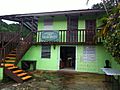
Café el Gran Batey (coffee roasting)

See also
 In Spanish: Ángeles (Puerto Rico) para niños
- List of communities in Puerto Rico

All content from Kiddle encyclopedia articles (including the article images and facts) can be freely used under Attribution-ShareAlike license, unless stated otherwise. Cite this article:
Ángeles, Utuado, Puerto Rico Facts for Kids. Kiddle Encyclopedia.