
2016 Kumamoto earthquakes facts for kids

United States Geological Survey shake map for the April 16 earthquake; a maximum Mercalli intensity scale value of 8.8 was observed just east of Kumamoto City.
|
|

 
|
|
| UTC time | 2016-04-15 16:25:06 |
|---|---|
| ISC event | 610289055 |
| USGS-ANSS | ComCat |
| Local date | April 16, 2016 |
| Local time | 01:25 JST (UTC+9) |
| Magnitude | 7.0 Mw |
| Depth | 10 km |
| Epicenter | 32°46′55.2″N 130°43′33.6″E / 32.782000°N 130.726000°E |
| Type | Strike-slip |
| Areas affected | Kumamoto Prefecture, Kyushu, Japan |
| Max. intensity | IX (Violent) |
| Foreshocks | 6.2Mw, April 14, 2016 12:26:36 (UTC), 21:26:36 (JST) |
| Casualties | Foreshock: 9 dead, 1,108 injured Mainshock: 41 dead, 2,021 injured Total:50 dead, 3,129 injured |
The 2016 Kumamoto earthquakes happened on April 14−16, 2016 near Kumamoto Prefecture in southern Japan. A foreshock of magnitude 6.2 on the Richter scale happened on the evening of April 14 at 21:26 Japan Standard Time. The main earthquake happened at 1:25 am JST with a magnitude of 7.0 on April 16.
A total of 48 people died in the two earthquakes. About 3,000 more were injured. There was severe damage in and around Kumamoto. Many structures including Kumamoto-Castle fell and some of them caught fire and infrastructures, especially water, electricity and gas supply are destructed. More than 44,000 people had to leave the area because of the disaster and most of them suffer hard living in shelters.
Images for kids
-
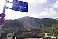
The Great Aso Bridge in Minamiaso collapsed into the Kurokawa River due to a landslide
-
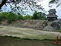
The north-west Inui Turret and wall of Kumamoto Castle.
-
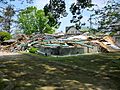
The ruins of the historic Janes' Residence
-
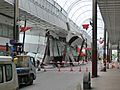
The damaged Sunlive Kengun in the pedestrian arcade in downtown Kumamoto.


See also
 In Spanish: Terremoto de Kumamoto de 2016 para niños
