
2024 Sea of Japan earthquake facts for kids
| 令和6年能登半島地震 | |
 |
|

Location in Japan
|
|
| UTC time | 2024-01-01 07:10:09 |
|---|---|
| ISC event | 636373819 |
| USGS-ANSS | ComCat |
| Local date | 1 January 2024 |
| Local time | 16:10:09 JST (UTC+9) |
| Duration | c. 40 seconds |
| Magnitude | 7.6 MJMA 7.5 Mw |
| Depth | 10 km (6 mi) (USGS) |
| Epicenter | 37°29′53″N 137°14′31″E / 37.498°N 137.242°E |
| Type | Reverse |
| Areas affected | Japan |
| Max. intensity |
|
| Tsunami | 1.2 m (3.9 ft) |
| Landslides | Yes |
| Foreshocks | 5.7 MJMA |
| Aftershocks | ≥60, largest being 6.1 MJMA |
| Casualties | 48 dead, 109 injured, 2 cardiac arrests |
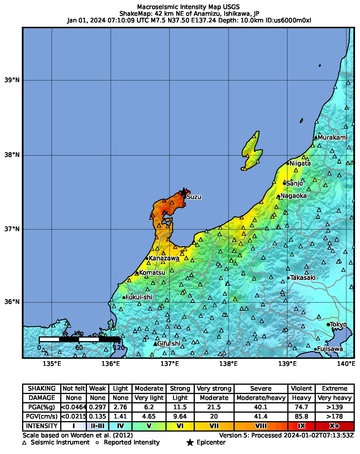
On 1 January 2024, at 16:10 JST (07:10 UTC), a MJMA7.6 or Mw7.5 earthquake struck 7 km (4.3 mi) north-northwest of Suzu, located in the Noto Peninsula of Ishikawa Prefecture, Japan. It was the largest earthquake in the country since the 2015 Ogasawara earthquake.
The Japan Meteorological Agency (JMA) officially named this earthquake the 2024 Noto Peninsula Earthquake (Japanese: 令和6年能登半島地震, Hepburn: Reiwa 6-nen Noto-hantō Jishin). It also led to Japan's first major tsunami warning since the 2011 Tōhoku earthquake, and a tsunami measuring over 1.2 m (4 ft) was observed along the Sea of Japan.
Contents
Tectonic setting
The northeastern tip of the Noto Peninsula has been subject to an earthquake swarm for three years; the earthquake is the largest event in this swarm so far, surpassing a Mw 6.3 event that took place in May 2023. The earthquake was the strongest to hit the Sea of Japan region since 1983.
Japan is situated on a convergent boundary between the Pacific, Philippine Sea, Okhotsk and Amurian Plates. Along the island arc's east and southeast coasts, subduction of the Pacific and Philippine Sea Plates occurs at the Japan Trench and Nankai Trough, respectively. The west coast of Honshu, bordering the Sea of Japan, is a north–south trending convergent boundary. This boundary between the Amurian and Okhotsk Plates is thought to be an incipient subduction zone, consisting of eastward-dipping thrust faults. Convergent tectonics have been occurring in the region since the end of the Pliocene. Earthquakes and tsunamis are produced on thrust faults that form the boundary, with magnitudes in the range of 6.8–7.9. Major earthquakes and tsunamis along this boundary occurred in 1741, 1833, 1940, 1964, 1983 and 1993, although the origin of the 1741 tsunami remains open to debate.
Earthquake
The United States Geological Survey (USGS) reported a moment magnitude of 7.5 and a focal depth of 10 km (6.2 mi) for the earthquake. The Japan Meteorological Agency recorded a magnitude of MJMA 7.6. The focal mechanism of the mainshock corresponded to shallow reverse faulting along a northeast-trending plane dipping northwest or southeast, happening along the convergent boundary between the Okhotsk Plate and Amurian Plate. A magnitude 5.5 foreshock struck four minutes before the mainshock, while a magnitude 6.2 aftershock struck nine minutes later. About 60 aftershocks were recorded after the earthquake, with at least seven of them registering a magnitude of 5.0 and above.

According to a finite fault model released by the USGS, the earthquake rupture extended approximately 200 km (120 mi) from southeast of the Noto Peninsula to Sado Island along a southeast-dipping fault. The zones of the largest slip occurred northeast and southwest of the hypocenter. The latter patch produced the largest displacement of 3.67 m (12 ft) beneath the peninsula. Another zone of slip occurred between the peninsula and Sado Island, producing up to 1.86 m (6 ft) of slip. The fault likely ruptured towards the seafloor.
The Geospatial Information Authority of Japan said parts of the country moved up to 1.3 m (4 ft 3 in) westwards with the maximum displacement observed at Wajima due to crustal deformation. At Anamizu, land shifted 1 m (3 ft 3 in) westwards. However, the agency said these movement could be slope or local ground movement instead.
Intensity
The Japan Meteorological Agency said it recorded a maximum seismic intensity of 7 (Shindo 7), the highest level on its seismic intensity scale, the first time that an earthquake of that intensity had been observed in the country since 2018. The maximum intensity was reported in Shika, Ishikawa Prefecture. Intensity 6+ was recorded in Nanao, Wajima, Suzu and Anamizu. Intensity 6– was recorded in Nagaoka in Niigata Prefecture and in Ishikawa's Nakanoto and Noto. The earthquake was also felt by residents in Tokyo and across the Kanto Region and as far as Aomori Prefecture in the northern tip of Honshu to Kyushu in the south of the country.
| Intensity | Prefecture | Location |
|---|---|---|
| 7 | Ishikawa | Shika |
| 6+ | Ishikawa | Nanao, Wajima, Suzu, Anamizu |
| 6- | Ishikawa | Nakanoto, Noto |
| Niigata | Nagaoka | |
| 5+ | Ishikawa | Hakui, Hōdatsushimizu, Kanazawa, Komatsu, Kaga, Kahoku, Nomi |
| Niigata | Sanjō, Kashiwazaki, Mitsuke, Minamiuonuma, Kariwa, Itoigawa, Myōkō, Jōetsu, Chūō-ku, Minami-ku, Nishi-ku, Nishikan-ku, Tsubame, Aga, Sado | |
| Toyama | Toyama, Funahashi, Takaoka, Himi, Oyabe, Nanto, Imizu | |
| Fukui | Awara | |
| 5- | Ishikawa | Hakusan, Tsubata, Uchinada |
| Niigata | Ojiya, Kamo, Tōkamachi, Izumozaki, Kita-ku, Higashi-ku, Kōnan-ku, Akiha-ku, Gosen, Agano | |
| Toyama | Namerikawa, Kurobe, Kamiichi, Tateyama, Asahi, Tonami | |
| Fukui | Fukui, Sakai | |
| Nagano | Nagano, Shinano, Sakae | |
| Gifu | Takayama, Hida |
Long Period Ground Motion
The JMA also reported that the Noto Region of Ishikawa Prefecture registered the highest possible Long Period Ground Motion (LPGM) intensity of 4.
Tsunami
Japan

Large parts of Japan's western coast, from Hokkaido to Nagasaki Prefectures were immediately placed under a tsunami warning after the earthquake struck, with evacuation orders issued in Ishikawa, Niigata, Toyama, and Yamagata prefectures. The earthquake triggered a major tsunami warning, the first one since the 2011 Tōhoku earthquake. Public broadcaster NHK said tsunami waves of 5 m (16 ft) could be expected, though much smaller waves later arrived. The Pacific Tsunami Warning Center said dangerous tsunami waves were possible within 300 km (190 mi) of the epicenter. The evacuation orders affected 51,000 people, with 1,000 evacuees finding shelter at the Japan Air Self-Defense Force base in Wajima in Ishikawa Prefecture alone.
The first waves were reported to have arrived at around 16:21, with tsunami waves exceeding 1.2 m (4 ft) striking Wajima. A tsunami measuring 90 cm (35 in) struck Kanazawa, while a tsunami of 80 cm (31 in) struck Toyama Prefecture and Sakata, Yamagata Prefecture. Waves measuring 50 cm (20 in) were recorded in Nanao and Tsuruga while waves measuring 40 cm (16 in) were recorded at Kashiwazaki, Toyooka, Tobishima, and Sado Island. In Toyama city, a 0.5 m (1 ft 8 in) wave was reported. In Hokkaido, waves of up to 60 cm (24 in) were reported in Setana, while 50 cm (20 in) waves struck Okushiri Island.
In Suzu, homes were washed off their foundations and some were driven further inland. The tsunami capsized many fishing vessels and carried some onto land. Building collapses and overturned cars were observed from a news helicopter flyover of the city. A resident recalled tsunami waves washing over a road, picking up cars and debris; he also estimated the waves were 3 m (9.8 ft) above tide level. Ishikawa Prefecture's governor, Hiroshi Hase, said the tsunami flooded the Iida Port area by up to 100 m (330 ft) inland. In Shiga, a series of tsunami waves reached the port at 17:40.
In the Naoetsu area of Niigata, the tsunami damaged buildings.
The major tsunami warning was later downgraded to a tsunami warning at 20:30, about four hours after the earthquake. These tsunami warnings were later downgraded to advisories, which were eventually lifted at 10:01 on 2 January, about 18 hours after the earthquake.
Elsewhere along the Sea of Japan
The coastlines of Gangwon Province and Pohang in South Korea could experience a rise in sea levels according to the Korea Meteorological Administration. Waves of 0.3 m (1 ft) were anticipated along the nation's east coast from 18:29 to 19:17 local time. A 0.45 m (1 ft 6 in) tsunami was later reported to have occurred in Gangwon. A 0.85 m (3 ft) high wave reportedly struck Mukho at around 20:00 local time. Tsunamis with heights of 0.66 m (2 ft 2 in) was recorded in Uljin; 0.45 m (1 ft 6 in) in Sokcho and 0.39 m (1 ft 3 in) in Gangneung. It is thought to be the first tsunami of over 0.5 m (1 ft 8 in) observed in the country since 1993. According to Yonhap News Agency, citing North Korean state radio, a tsunami warning was issued with waves of 2.08 m (6 ft 10 in) potentially hitting the country's east coast.
Warnings for tsunami waves estimated to reach 1 m (3 ft) were also issued in Russia, particularly along the west coast of Sakhalin Island, where evacuations were said to be conducted, although Russia later said that no evacuations were taking place there. Tsunami warnings were also declared in Vladivostok and Nakhodka. The Emergencies Ministry of Russia said "response teams are ready to deal with the possible consequences of a tsunami." City officials in Vladivostok later said "no tsunami was observed" while in Nakhodka, "the tsunami passed almost unnoticed."
Impact
All 48 recorded fatalities were in Ishikawa and attributed to collapsing houses. Twenty people died in Suzu, 19 in Wajima, five in Nanao, two in Anamizu, and one each in Hakui and Shika. One hundred and nine people were also injured across seven prefectures.
In Wajima, at least 50 houses collapsed. A fire occurred in the city around 17:00. Due to damaged roads, firefighters were unable to extinguish the flames, which consumed an estimated 200 buildings, including many homes. More than 30 people were injured in the city, while many more injuries were reported in Suzu, where many houses were engulfed in flames. The Ishikawa Nanao Police Station said collapsed homes trapped people before they were rescued. At least 14 people were buried by collapsed homes in Wajima, while multiple injuries were reported by the local fire and health departments. A spokesperson at Wajima Municipal Hospital said people had broken bones or were injured by falling objects. Besides the two fatalities, one person was injured and two houses collapsed in Shika. In Anamizu, one person was unconscious and nine buildings collapsed. In Suzu, 53 homes collapsed. Across the mountainous region of the peninsula, landslides were widespread.
Homes in Shiromaru, Noto, were destroyed by fire, and the tsunami washed debris onto streets. Operations of the Noto Airport were suspended after five cracks as long as 10 m (33 ft) appeared on the runway; the terminal of the airport also sustained damage.
At least 18 people in Toyama Prefecture were injured, eight of them after the ceiling of a pachinko parlor collapsed in Toyama City. Over 100 buildings were damaged. In Niigata Prefecture, 19 people were injured, many buildings collapsed, and roads were damaged. One cardiac arrest case was reported in an elderly person in the prefecture, likely linked to the earthquake. In Fukui Prefecture, six people sustained minor injuries. Two injuries were also reported each in Osaka and Hyōgo Prefectures, while another person was injured in Gifu Prefecture.
Cracked roads and broken water mains were reported in the cities of Himi and Oyabe, Toyama Prefecture. Liquefaction occurred in Niigata city; sewer pipes also ruptured and many homes were left without water. In Shika, water was being rationed daily at six litres per person following the earthquake. Thirty homes, most in Nishi-ku, were damaged. The Onohiyoshi Shrine in Kanazawa also sustained damage. A landslide struck the main expressway between Toyama and Kanazawa, ripping apart several hundred meters of roadway.
NTT Docomo, Rakuten Mobile, Softbank and KDDI reported telecommunications and internet service disruptions in Ishikawa and Niigata prefectures, while NTT West said its facilities were damaged by the earthquake. At Shika Nuclear Power Plant, an explosion occurred near the power transformer of the No. 2 reactor, while the transformer at the No. 1 reactor was rendered inoperable due to an oil spill. At least 36,000 households lost power following the earthquake.
Reactions
Taiwanese President Tsai Ing-Wen, Philippine president Bongbong Marcos, United States President Joe Biden, and British Prime Minister Rishi Sunak sent condolences and said that they are ready to send any assistance to Japan. The Armed Forces of the Philippines also offered to collaborate with the JSDF in its response to the earthquake.
See also
 In Spanish: Terremoto de la península de Noto de 2024 para niños
