
Aberdeen, Ohio facts for kids
Quick facts for kids
Aberdeen, Ohio
|
|
|---|---|
|
Village
|
|

Looking east on U.S. Route 52 in Aberdeen
|
|

Location of Aberdeen, Ohio
|
|

Location of Aberdeen in Brown County
|
|
| Country | United States |
| State | Ohio |
| County | Brown |
| Township | Huntington |
| Founded | 1795 |
| Platted | 1816 |
| Incorporated | July 5, 1816 |
| Area | |
| • Total | 1.63 sq mi (4.23 km2) |
| • Land | 1.35 sq mi (3.50 km2) |
| • Water | 0.28 sq mi (0.74 km2) |
| Elevation | 515 ft (157 m) |
| Population
(2010)
|
|
| • Total | 1,638 |
| • Estimate
(2019)
|
1,604 |
| • Density | 1,188.15/sq mi (458.66/km2) |
| Time zone | UTC-5 (Eastern (EST)) |
| • Summer (DST) | UTC-4 (EDT) |
| ZIP code |
45101
|
| Area codes | 937, 326 |
| FIPS code | 39-00142 |
| GNIS feature ID | 1056195 |
Aberdeen is a village in Huntington Township, Brown County, Ohio, United States, along the Ohio River 50 miles (80 km) southeast of Cincinnati. The population was 1,638 at the 2010 census.
Gallery
-
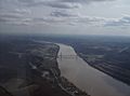
Along the Ohio River at Aberdeen.
-
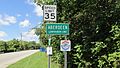
Aberdeen corporation limit sign.
-
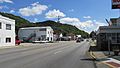
Looking east on US Highway 52 in Aberdeen.


History
Aberdeen was founded by James Edwards in 1795 and platted by Nathan Ellis in 1816. It was incorporated on July 5, 1816.
Geography
Aberdeen is located at 38°39′54″N 83°46′3″W / 38.66500°N 83.76750°W (38.665027, -83.767638).
According to the United States Census Bureau, the village has a total area of 1.63 square miles (4.22 km2), of which 1.35 square miles (3.50 km2) is land and 0.28 square miles (0.73 km2) is water.
Climate
| Climate data for Aberdeen | |||||||||||||
|---|---|---|---|---|---|---|---|---|---|---|---|---|---|
| Month | Jan | Feb | Mar | Apr | May | Jun | Jul | Aug | Sep | Oct | Nov | Dec | Year |
| Average high °F (°C) | 42.0 (5.6) |
44.5 (6.9) |
55.2 (12.9) |
66.3 (19.1) |
76.2 (24.6) |
84.4 (29.1) |
88.1 (31.2) |
86.7 (30.4) |
81.2 (27.3) |
70.0 (21.1) |
56.0 (13.3) |
44.8 (7.1) |
66.3 (19.1) |
| Average low °F (°C) | 22.8 (−5.1) |
23.4 (−4.8) |
31.7 (−0.2) |
40.5 (4.7) |
50.1 (10.1) |
59.3 (15.2) |
63.5 (17.5) |
62.2 (16.8) |
55.4 (13.0) |
43.3 (6.3) |
33.6 (0.9) |
25.5 (−3.6) |
42.6 (5.9) |
| Average precipitation inches (mm) | 3.7 (94) |
3.1 (79) |
4.3 (110) |
3.8 (97) |
4.2 (110) |
3.9 (99) |
4.5 (110) |
3.9 (99) |
3.2 (81) |
2.6 (66) |
3.2 (81) |
3.6 (91) |
43.9 (1,120) |
| Source: Weatherbase | |||||||||||||
Demographics
| Historical population | |||
|---|---|---|---|
| Census | Pop. | %± | |
| 1820 | 87 | — | |
| 1830 | 165 | 89.7% | |
| 1840 | 405 | 145.5% | |
| 1850 | 808 | 99.5% | |
| 1860 | 836 | 3.5% | |
| 1870 | 871 | 4.2% | |
| 1880 | 885 | 1.6% | |
| 1890 | 874 | −1.2% | |
| 1900 | 711 | −18.6% | |
| 1910 | 568 | −20.1% | |
| 1920 | 477 | −16.0% | |
| 1930 | 452 | −5.2% | |
| 1940 | 497 | 10.0% | |
| 1950 | 551 | 10.9% | |
| 1960 | 774 | 40.5% | |
| 1970 | 1,165 | 50.5% | |
| 1980 | 1,566 | 34.4% | |
| 1990 | 1,329 | −15.1% | |
| 2000 | 1,603 | 20.6% | |
| 2010 | 1,638 | 2.2% | |
| 2019 (est.) | 1,604 | −2.1% | |
| U.S. Decennial Census | |||
2010 census
As of the census of 2010, there were 1,638 people, 760 households, and 454 families living in the village. The population density was 1,213.3 inhabitants per square mile (468.5/km2). There were 882 housing units at an average density of 653.3 per square mile (252.2/km2). The racial makeup of the village was 96.2% White, 1.8% African American, 0.1% Native American, 0.2% Asian, 0.2% from other races, and 1.5% from two or more races. Hispanic or Latino of any race were 0.9% of the population.
There were 760 households, of which 26.3% had children under the age of 18 living with them, 39.3% were married couples living together, 14.5% had a female householder with no husband present, 5.9% had a male householder with no wife present, and 40.3% were non-families. 35.0% of all households were made up of individuals, and 13.7% had someone living alone who was 65 years of age or older. The average household size was 2.16 and the average family size was 2.75.
The median age in the village was 41.9 years. 21.1% of residents were under the age of 18; 9.5% were between the ages of 18 and 24; 24.1% were from 25 to 44; 28.8% were from 45 to 64; and 16.6% were 65 years of age or older. The gender makeup of the village was 46.6% male and 53.4% female.
See also
 In Spanish: Aberdeen (Ohio) para niños
