
Acacia Ridge, Queensland facts for kids
Quick facts for kids Acacia RidgeBrisbane, Queensland |
|||||||||||||||
|---|---|---|---|---|---|---|---|---|---|---|---|---|---|---|---|

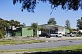
Warehouses in industrial areas of the suburb
|
|||||||||||||||

Acacia Ridge
Location in Queensland
|
|||||||||||||||
| Population | 7,429 (2016 census) | ||||||||||||||
| • Density | 864/km2 (2,240/sq mi) | ||||||||||||||
| Postcode(s) | 4110 | ||||||||||||||
| Area | 8.6 km2 (3.3 sq mi) | ||||||||||||||
| Time zone | AEST (UTC+10:00) | ||||||||||||||
| Location | 15.7 km (10 mi) S of Brisbane CBD | ||||||||||||||
| LGA(s) | City of Brisbane (Moorooka Ward) |
||||||||||||||
| State electorate(s) |
|
||||||||||||||
| Federal Division(s) | Moreton | ||||||||||||||
|
|||||||||||||||
Acacia Ridge is a southern suburb in the City of Brisbane, Queensland, Australia. In the 2016 census, Acacia Ridge had a population of 7,429 people.
Contents
History
The name Acacia Ridge derives from the number of Acacia species growing in the area. The suburb was established after the Second World War to house returning servicemen and their families. Many of the original post-war dwellings still stand today.
Demographics
In the 2011 census, Acacia Ridge recorded a population of 6,945 people, 50.1% female and 49.9% male. The median age of the Acacia Ridge population was 34 years, 3 years below the national median of 37. 61.6% of people living in Acacia Ridge were born in Australia, compared to the national average of 69.8%; the next most common countries of birth were New Zealand 3.8%, England 2.9%, India 2%, Philippines 1.5%, Vietnam 1.2%. 67.8% spoke only English at home; the next most popular languages were 2% Vietnamese, 2% Arabic, 1.5% Spanish, 1.3% Bosnian, 1.2% Samoan.
Transport
Acacia Ridge is home to one of Queensland's largest railway freight yards, dealing with interstate freight and the break-of-gauge from 1,067 mm (3 ft 6 in) to 1,435 mm (4 ft 8 1⁄2 in). In 2008, the Beaudesert Road level crossing was replaced by an overbridge, so that the sidings in the yard could be extended for the shunting of longer 1500m trains. Because space is not available for all potential users of this yard, another hub at Bromelton has been proposed. In 2009, the line between Acacia Ridge and Bromelton was converted to dual gauge to suit a break-of-gauge hub at Bromelton. Acacia Ridge also borders one corner of Archerfield Airport; a small, privately owned airport.
Heritage listings

Acacia Ridge has a number of heritage-listed sites, including:
- 174 Mortimer Road: Acacia Ridge Air Raid Shelter
Economy
From 1966 until the mid-1980s, Acacia Ridge accommodated one of Holden's main vehicle manufacturing plants, which produced both full-sized and smaller models including the Holden Gemini. When local production of the Gemini ceased in October 1984, the manufacturing plant closed down. The manufacturer remained, retaining a small area of the site for its regional headquarters until the early 2000s, when it relocated to Murarrie. Since closure of the plant, Woolworths occupied the area, utilising its space as a regional distribution centre until recently, when an independent retail grocery chain resumed the site for similar purposes.
On the opposite side of Beaudesert Road from the former manufacturing plant, Toyota has based its southern Queensland regional headquarters. This site is primarily used for managerial and distribution related duties, as opposed to vehicle production.
Acacia Ridge is home to one of Queensland's largest railway freight yards, dealing with interstate freight and the break-of-gauge from 1,067 mm (3 ft 6 in) to 1,435 mm (4 ft 8 1⁄2 in). In 2008, the Beaudesert Road level crossing was replaced by an overbridge, so that the sidings in the yard could be extended for the shunting of longer 1500 m trains. Because space was not sufficient for all potential users of this yard. In 2009, the line between Acacia Ridge and Bromelton was converted to dual gauge to enable another break-of-gauge freight hub to be established at Bromelton in 2017.
Acacia Ridge also borders one corner of Archerfield Airport; a small, privately owned airport (27°34′09″S 153°00′28″E / 27.5693°S 153.0077°E).
Education

Acacia Ridge State School is a government primary (Early Childhood-6) school for boys and girls at 67 Nyngam Street (27°34′46″S 153°00′58″E / 27.5795°S 153.0160°E). In 2017, the school had an enrolment of 302 students with 28 teachers (26 full-time equivalent) and 27 non-teaching staff (16 full-time equivalent). It includes a special education program.
Watson Road State School is a government primary (Prep-6) school for boys and girls at 210 Watson Road (27°35′35″S 153°01′06″E / 27.5931°S 153.0184°E). In 2017, the school had an enrolment of 122 students with 15 teachers (13 full-time equivalent) and 14 non-teaching staff (9 full-time equivalent).
Lady of Fatima Primary School is a Catholic primary (Prep-6) school for boys and girls at 350 Mortimer Road (27°34′45″S 153°01′22″E / 27.5791°S 153.0227°E). In 2017, the school had an enrolment of 151 students with 15 teachers (13 full-time equivalent) and 10 non-teaching staff (5 full-time equivalent).
The Aboriginal & Islander Independent Community School (also known as The Murri School) is a private primary and secondary (Prep-12) school for boys and girls at 1277 Beaudesert Road (27°34′53″S 153°01′33″E / 27.5815°S 153.0257°E). In 2017, the school had an enrolment of 245 students with 25 teachers (22 full-time equivalent) and 35 non-teaching staff (29 full-time equivalent).
YMCA Vocational School is a private secondary (7-12) facility of YMCA Vocational School at Kingston at 24 Mannington Road (27°35′06″S 153°01′33″E / 27.5849°S 153.0258°E).
There is no government secondary school in Acacia Ridge. The nearest government secondary schools are:
- Glenala State High School in Durack to the west
- Sunnybank State High School in Sunnybank to the east
- Calamvale Community College in Calamvale to the south
Notable residents
- Mabior Chol, AFL player
- Steven Herrick, poet and author
- Jeff Horn, boxer
- Steve Price, rugby league player
- Johnathan Thurston, rugby league player
- Joel Turner, musician
Images for kids
-
Acacia Ridge Community Centre, 2013
.jpg)
