
Accident, Maryland facts for kids
Quick facts for kids
Accident, Maryland
|
|
|---|---|

James Drane House in 2012
|
|

Location of Accident, Maryland
|
|

Accident, Maryland
Location in Maryland

Accident, Maryland
Location in the United States

Accident, Maryland
Location in North America
|
|
| Country | |
| State | |
| County | |
| Patented | 1786 |
| Incorporated | 1916 |
| Area | |
| • Total | 0.49 sq mi (1.28 km2) |
| • Land | 0.49 sq mi (1.28 km2) |
| • Water | 0.00 sq mi (0.00 km2) |
| Elevation | 2,385 ft (727 m) |
| Population
(2020)
|
|
| • Total | 338 |
| • Density | 684.21/sq mi (263.97/km2) |
| Demonym(s) | Accidental |
| Time zone | UTC-5 (Eastern (EST)) |
| • Summer (DST) | UTC-4 (EDT) |
| ZIP code |
21520
|
| Area codes | 301, 240 |
| FIPS code | 24-00225 |
| GNIS feature ID | 0582858 |
Accident ( ak-sə-dent) is a town in Garrett County, Maryland, United States. The population was 338 at the 2020 United States census. Accident has been noted for its unusual place name. A person from Accident is called an "Accidental".
Contents
History
Accident, Garrett County, Maryland was one of the early settlements in the far west of Maryland.
When Lord Baltimore opened up the area he called Monocacy Manor to settlement in the early 1770s, Brooke Beall secured permission to survey 778 acres (3.15 km2). It will never be known for certain how Beall came to choose this particular spot, but the surveyor was given clear instructions where to start. He was to begin "in the center between two bounded white oak trees, standing on the North Side of the South fork of Bear Creek in or near a glade about one Hundred yards from said Run, about one or two Miles above a Lick known by the name of the "Cole Mine Lick", about four miles (6 km) above the mouth of Broad Creek and about one mile (1.6 km) East of a Ridge of the Negro Mountain." John Hanson, Jr., later a delegate to the Continental Congress, and President of the United States in Congress Assembled, on April 14, 1774, surveyed the land, finding that it only contained 682 acres (2.76 km2). For the next twelve years nothing was done with the survey. Revolution intervened, and it was not until February 15, 1786, that the land was granted by means of a patent to William Deakins. The following year the surrounding countryside was surveyed into military lots by Francis Deakins, lots that were meant as compensation for the soldiers who served from Maryland during the War of independence. Each soldier who served for two years received one lot of 50 acres (200,000 m2), officers received four lots of 50 acres (200,000 m2) each.

Kaese Mill was listed on the National Register of Historic Places in 1984. The James Drane House was listed in 1985.
Geography
Accident is located at 39°37′41″N 79°19′12″W / 39.62806°N 79.32000°W (39.628074, -79.319996).
According to the United States Census Bureau, the town has a total area of 0.49 square miles (1.27 km2), all land.
Demographics
| Historical population | |||
|---|---|---|---|
| Census | Pop. | %± | |
| 1880 | 114 | — | |
| 1940 | 236 | — | |
| 1950 | 242 | 2.5% | |
| 1960 | 237 | −2.1% | |
| 1970 | 237 | 0.0% | |
| 1980 | 246 | 3.8% | |
| 1990 | 349 | 41.9% | |
| 2000 | 353 | 1.1% | |
| 2010 | 325 | −7.9% | |
| 2020 | 338 | 4.0% | |
| U.S. Decennial Census | |||
2010 census
As of the census of 2010, there were 325 people, 141 households, and 86 families residing in the town. The population density was 663.3 inhabitants per square mile (256.1/km2). There were 173 housing units at an average density of 353.1 per square mile (136.3/km2). The racial makeup of the town was 97.8% White, 0.6% Native American, 0.3% Asian, 0.6% from other races, and 0.6% from two or more races. Hispanic or Latino of any race were 0.6% of the population.
There were 141 households, of which 33.3% had children under the age of 18 living with them, 45.4% were married couples living together, 11.3% had a female householder with no husband present, 4.3% had a male householder with no wife present, and 39.0% were non-families. 32.6% of all households were made up of individuals, and 19.1% had someone living alone who was 65 years of age or older. The average household size was 2.30 and the average family size was 2.99.
The median age in the town was 34.5 years. 26.2% of residents were under the age of 18; 10.1% were between the ages of 18 and 24; 25.3% were from 25 to 44; 22.8% were from 45 to 64; and 15.7% were 65 years of age or older. The gender makeup of the town was 45.5% male and 54.5% female.
Transportation
_just_north_of_Cemetery_Road_in_Accident,_Garrett_County,_Maryland.jpg)
The primary method of transportation to and from Accident is by road. One state-maintained highway, U.S. Route 219, serves the town directly, following Main Street through the middle of Accident. To the north, US 219 connects Accident to Interstate 68 and U.S. Route 40, along with the town of Grantsville, before heading into Pennsylvania. Heading south, US 219 connects to Maryland Route 42, Maryland Route 39, Maryland Route 135 and U.S. Route 50, along with the towns of Oakland and Mountain Lake Park, before it enters West Virginia.
Notable people
- Wendell R. Beitzel, member of Maryland House of Delegates
- James Drane, builder and first owner of the historical Drane House
Images for kids
-
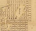
Detail from the original Francis Deakins 1787 survey of lots westward of Fort Cumberland, Library of Congress. Reproduced in Edward C. Papenfuse and Joseph M. Coale, The Maryland State Archives Atlas of Historical Maps of Maryland, (Baltimore: Johns Hopkins University Press, 2003), p. 204
See also
 In Spanish: Accident (Maryland) para niños
