Adams County, Washington facts for kids
Quick facts for kids
Adams County
|
|
|---|---|

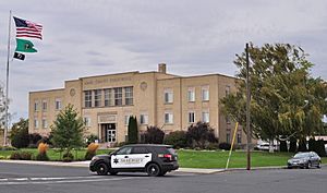
Adams County Courthouse (erected 1941) in 2014
|
|

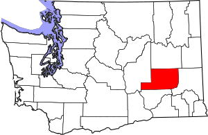
Location within the U.S. state of Washington
|
|
 Washington's location within the U.S. |
|
| Country | |
| State | |
| Founded | November 28, 1883 |
| Named for | John Adams |
| Seat | Ritzville |
| Largest city | Othello |
| Area | |
| • Total | 1,930 sq mi (5,000 km2) |
| • Land | 1,925 sq mi (4,990 km2) |
| • Water | 4.9 sq mi (13 km2) 0.3%% |
| Population
(2020)
|
|
| • Total | 20,613 |
| • Estimate
(2021)
|
20,621 |
| • Density | 10/sq mi (4/km2) |
| Time zone | UTC−8 (Pacific) |
| • Summer (DST) | UTC−7 (PDT) |
| Congressional district | 4th |
Adams County is a county in the U.S. state of Washington. As of the 2020 census, the population was 20,613. The county seat is at Ritzville, and its largest city is Othello. The county was formed out of Whitman County in November 1883 and is named for the second President of the United States, John Adams.
Adams County's two most populous cities are Ritzville and Othello. Ritzville is located in the northeastern corner of the county at the junction of I-90 and US 395, making it a popular stop for travelers. Ritzville is an hour's drive from Spokane. Othello is located in the southwestern panhandle of the county.
Contents
Geography
According to the U.S. Census Bureau, the county has a total area of 1,930 square miles (5,000 km2), of which 1,925 square miles (4,990 km2) is land and 4.9 square miles (13 km2) (0.3%) is water.
Major highways
Adjacent counties
- Lincoln County - north
- Whitman County - east
- Franklin County - south
- Grant County - west
National protected areas
- Columbia National Wildlife Refuge (part)
- Saddle Mountain National Wildlife Refuge (part)
Demographics
| Historical population | |||
|---|---|---|---|
| Census | Pop. | %± | |
| 1890 | 2,098 | — | |
| 1900 | 4,840 | 130.7% | |
| 1910 | 10,920 | 125.6% | |
| 1920 | 9,623 | −11.9% | |
| 1930 | 7,719 | −19.8% | |
| 1940 | 6,209 | −19.6% | |
| 1950 | 6,584 | 6.0% | |
| 1960 | 9,929 | 50.8% | |
| 1970 | 12,014 | 21.0% | |
| 1980 | 13,267 | 10.4% | |
| 1990 | 13,603 | 2.5% | |
| 2000 | 16,428 | 20.8% | |
| 2010 | 18,728 | 14.0% | |
| 2020 | 20,613 | 10.1% | |
| 2021 (est.) | 20,621 | 10.1% | |
| U.S. Decennial Census 1790–1960 1900–1990 1990–2000 2010–2020 |
|||
Adams County and Franklin County have the highest per capita percentage of Latino residents in the state.
2010 census
As of the 2010 census, there were 18,728 people, 5,720 households, and 4,410 families living in the county. The population density was 9.7 inhabitants per square mile (3.7/km2). There were 6,242 housing units at an average density of 3.2 per square mile (1.2/km2). The racial makeup of the county was 62.5% white, 1.9% American Indian, 0.7% Asian, 0.6% black or African American, 31.5% from other races, and 2.8% from two or more races. Those of Hispanic or Latino origin made up 59.3% of the population. In terms of ancestry, 16.4% were German, 6.8% were Irish, 5.6% were English, and 2.2% were American.
Of the 5,720 households, 47.9% had children under the age of 18 living with them, 58.7% were married couples living together, 11.8% had a female householder with no husband present, 22.9% were non-families, and 18.8% of all households were made up of individuals. The average household size was 3.25 and the average family size was 3.71. The median age was 29.0 years.
The median income for a household in the county was $40,829 and the median income for a family was $43,551. Males had a median income of $35,695 versus $25,160 for females. The per capita income for the county was $16,689. About 19.0% of families and 25.1% of the population were below the poverty line, including 36.6% of those under age 18 and 12.6% of those age 65 or over.
Communities
Cities
Towns
Unincorporated communities
Ghost towns
- Keystone
- Marcellus (site of Griffith Cemetery) Lat: 47° 15' 24"N, Lon: 118° 23' 07"W, T20N R35E NE corner SE¼ of Sec 3 (8.5 miles north of Ritzville on Marcellus Rd, cemetery on the west).
See also
 In Spanish: Condado de Adams (Washington) para niños

