
Afar Region facts for kids
Quick facts for kids
Afar Regional State
ዓፋር
Qafár Rakaakayih Doolata |
|||
|---|---|---|---|
|
Regional State
|
|||
|
|||

Map of Ethiopia showing Afar Region
|
|||
| Country | Ethiopia | ||
| Capital | Semera | ||
| Area | |||
| • Total | 72,053 km2 (27,820 sq mi) | ||
| Population
(2017)
|
|||
| • Total | 1,812,002 | ||
| • Density | 25.14818/km2 (65.1335/sq mi) | ||
| ISO 3166 code | ET-AF | ||


The Afar Regional State is one of the nine regional states of Ethiopia. It is the homeland of the Afar people. The capital city is Semera.
Danakil Depression is in the north of the region. It has the lowest point in Ethiopia and one of the lowest in Africa. The southern part of the region has the valley of the Awash River. Other notable landmarks include the Awash and Yangudi Rassa National Parks.
Administrative zones
Like other Regions in Ethiopia, Afar is divided into administrative zones (and one special woreda).
- Administrative Zone 1: Awsi Rasu
- Administrative Zone 2: Kilbati Rasu
- Administrative Zone 3: Gabi Rasu
- Administrative Zone 4: Fanti Rasu
- Administrative Zone 5: Harri Rasu
- Argobba special woreda
Images for kids
-
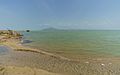
Afdera Lake
-
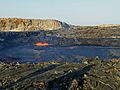
Erta Ale Volcano

.jpg)
See also
 In Spanish: Región Afar para niños

All content from Kiddle encyclopedia articles (including the article images and facts) can be freely used under Attribution-ShareAlike license, unless stated otherwise. Cite this article:
Afar Region Facts for Kids. Kiddle Encyclopedia.