
Aguadilla, Puerto Rico facts for kids
Quick facts for kids
Aguadilla
Municipio Autónomo de Aguadilla
|
|||
|---|---|---|---|
|
City and Municipality
|
|||

Aguadilla buildings and ocean view
|
|||
|
|||
| Nicknames:
Jardín del Atlántico, La Villa del Ojo de Agua, El Pueblo de los Tiburones
|
|||
| Anthem: Playita Aguadillana | |||

Map of Puerto Rico highlighting Aguadilla Municipality
|
|||
| Commonwealth | |||
| Founded | 1775 | ||
| Founded by | Luis de Córdova | ||
| Barrios | |||
| Area | |||
| • Total | 76.3 sq mi (198 km2) | ||
| • Land | 36.6 sq mi (95 km2) | ||
| • Water | 39.0 sq mi (101 km2) 51% | ||
| Elevation | 326 ft (99 m) | ||
| Population
(2020)
|
|||
| • Total | 55,101 | ||
| • Density | 722.2/sq mi (278.83/km2) | ||
| Demonym(s) | Aguadillanos | ||
| Racial groups | |||
| • 2020 Census | 48.1% Multiracial 21.0% White 4.1% Black 0.5% American Ind/AN 0.1% Asian 26.2% Other |
||
| Time zone | UTC−4 (AST) | ||
| ZIP Codes |
00603, 00604, 00605, 00690
|
||
| Area code(s) | 787/939 | ||
| Major routes | |||
| Website | aguadilla.gobierno.pr | ||


Aguadilla, founded in 1775 by Luis de Córdova, is a city and municipality located in the northwestern tip of Puerto Rico, bordered by the Atlantic Ocean to the north and west, north of Aguada, and Moca and west of Isabela. Aguadilla is spread over 15 barrios and Aguadilla Pueblo (the downtown area and the administrative center of the city). It is a principal city of Aguadilla-Isabela-San Sebastián Metropolitan Statistical Area.
Contents
History
According to sources, a Taíno settlement called Amamón was located close to the Culebrinas River.
The present territory of Aguadilla was originally part of the territory of Aguada. In 1775, the foundation of Aguadilla by Don Luis de Córdova was approved. But it wasn't until 1780 that the territory was properly segregated, making the founding of the town official. Originally, Aguadilla was constituted by the Victoria and Higüey wards. This region was already inhabited and known as Aguadilla before 1770. In 1776, Fray Íñigo Abbad y Lasierra in his description of the towns of the island, mentioned it as the "new Town of San Carlos of the Aguadilla." Nevertheless, according to Dr. Agustín Stahl in his Foundation of Aguadilla, it was not until 1780 that the town was officially founded. The construction of a new church and the proceedings to become an independent village began in the 1775.

The population in the Village of Aguadilla continued to increase constantly mainly due to its excellent port and strategic location in the route of the boats. In 1776, when Santo Domingo became independent for the first time, the Spanish descended loyals emigrated to Puerto Rico, mainly to Aguadilla, which caused the population to continue increasing significantly. In 1831, according to Don Pedro Tomás de Córdova, the party of Aguadilla belonged to Aguada. At this time, the territorial organization of Aguadilla was as follows: Pueblo Norte (North Town), Pueblo Sur (South Town), Ceiba Alta, Ceiba Baja, Montaña, Malezas, Aguacate, Dos Palmas, Camaseyes, Plainela, Borinquen, Arenales, Higüey, Corrales, Victoria, and Mangual.
Don Pedro Tomás de Córdova mentions the road of Aguadilla formed by Punta Borinquen and San Francisco, as the "fordeadero of the ships that travel from Europe to Havana and Mexico". He adds that its "port is the most frequented in the Island due to the proportions that it offers to refresh all class of ship."
In 1860, Aguadilla was officially declared a village. Several years later, when the island was territorially organized into seven departments, Aguadilla became the head of the third department that included the municipalities of Aguada, Isabela, Lares, Moca, Rincon, and San Sebastián. In January 1841 a Royal Order transferred the judicial party from Aguada to Aguadilla. In 1878, according to Don Manuel Ebeda y Delgado, the territorial organization of Aguadilla had varied a little. At this time Plainela, Higüey, and Mangual wards are not mentioned. The Dos Palmas ward appears as Palmar. Also at this time, three new wards are mentioned: Guerrero, Caimital Alto, and Caimital Bajo. In 1898, even with the change of sovereignty in the island, the territorial organization of Aguadilla is the same to that of 1878. Nevertheless, in the Census of 1899, downtown Aguadilla appears constituted by Higüey, Iglesia, Nueva, Santa Barbara, and Tamarindo wards. Malezas ward appears subdivided into Maleza Alta and Maleza Baja. From that time, the territorial organization of Aguadilla did not change, until 1948, when the Puerto Rico Department of Planning prepared the map of the city and its wards, and following instructions of city authorities, Higüey and parts of Caimital Alto wards are annexed to Downtown Aguadilla.
Ramey
Aguadilla was the site of the U.S. military's Ramey Air Force Base for almost five decades. During this period, Aguadilla was home to the Strategic Air Command 72d Bombardment Wing, Heavy equipped with B-52s, a very strategic facility during the Cold War. During the early years of the base and throughout World War II, Puerto Ricans in the area became more Americanized than in remote locations, and the after effects are still apparent in Aguadilla, and other towns like Aguada, Moca and Isabela.
The military and Puerto Ricans from the surrounding communities generally had good formal relations, but the undercurrent of resentment in many aspects of the relationship was always just below the surface. Many Americans stationed in the area did not even realize that the people all around them were even American citizens.
Though the infrastructure still exists, it was handed over to the Commonwealth of Puerto Rico in 1973. The aerial facilities are now civilian controlled by the Puerto Rico Ports Authority. The facilities now make up the Rafael Hernandez International Airport. The barracks now host the Faro Inn Suites, a 79-room hotel. The Officer's Club now hosts the Faro Conference Center, a 22,000-square-foot (2,000 m2) meeting facility. The hospital is now the Courtyard by Marriott Punta Borinquen Resort & Casino, a 150-room hotel with a casino and the first Marriott in Puerto Rico out of the San Juan Metropolitan Area.
Ramey also hosts the University of Puerto Rico - Aguadilla Campus and the Friedrich Froebel Bilingual School (K-9). The High School became Ramey Job Corps Campus and the elementary school became the Esther Feliciano Mendoza Middle School. Centro de Adiestramiento y Bellas Artes (CABA) since 1979 has been the only public school of arts in Puerto Rico (7-12). Ramey is also the site of the new Ramey Skating Park and a new "mariposario" (butterfly farm).
There is still an active part of the base that hosts the Coast Guard Borinquen Air Station. There are also other government agencies based at Ramey. They include the United States Department of Homeland Security, U.S. Customs & Border Protection's Office of Air and Marine and Office of Border Patrol, the Fuerzas Unidas de Rápida Acción (United Forces for Rapid Action) of the Puerto Rico Police Department and the Puerto Rico National Guard.
There is also a post office, the Centro de Servicios al Conductor (Driver's Services Center), a bakery, and a Banco Popular de Puerto Rico location.
San Antonio

The beginning of San Antonio Village was back in the mid-19th century. It was composed by 60 families. Originally the place where these families were located was known as Bajura de Vadi, place later to be known as San Antonio.
In 1918, as a consequence of the 1918 San Fermín earthquake, the village was totally destroyed by a tsunami. The families suffered the struggles cause by this natural disaster, due by the proximity of the village to the shore.
The residents of the village decided re-localize the village in a higher area further from shore. The new location was what today is known as Ramey.
At this new location prosperity was not to be delayed. Various leaders and commercial owners of the time, took a step to carry the village forward. Most of the poor houses disappeared.
The village's infrastructure started its evolution. Luis R. Esteves and Juan Garcia established the first two theaters in the area. A new was social club form, known as "Luz del Porvenir" (Light of the Future). A new school system was the pride of the village because it offered them the opportunity to give their children an education without having to go 9 miles (14 km) south downtown. There was also a new bakery and a post office, among other facilities. At this time, the village also began its Patron Festival.
The clothing industry was a major source of employment.
Prosperity and happiness came to an end, when the news that the Federal Government needed the land to build an air base that came to be known as Ramey Air Force Base. In September 1939, some 3,796 acres (15.4 km2) covered by sugar cane, was expropriated for the military at the cost of $1,215,000.
Since the foundation, the village has suffered three expropriations as a result of expansions to Ramey Air Force Base. This expropriations delayed and ended the plans to turn San Antonio into a town.
Today, the population of San Antonio consists of approximately 10 thousand people. It has a modern square, a Puerto Rico State Police Station, a coliseum, an industrial park, public housing, a baseball park, a public school system, shops, and many other, charasteristics of a small town. Also, as a characteristic of a town, has a flag and an emblem. The creation of the flag and emblem was done by Roberto Román Acevedo.
Tragedy on election day in 1944
On the early morning hours of November 7, 1944, Puerto Rico suffered the most violent railroad accident in its history in Aguadilla. Train No. 3 was traveling from San Juan to Ponce carrying passengers to their different hometowns for the island general elections to be held that same day. It stopped at the Jimenez Station in Aguadilla for a routine engineer and boilerman exchange with Train No. 4 which was heading towards San Juan. The engineer assigned to Train No. 3's ride from Jimenez Station to Ponce was Jose Antonio Roman, an experienced freight train engineer, but who had never worked in passenger travel. When the train left the station at 2:00 am, it was hauling 6 passenger cars with hundreds of commuters and two freight cars.
At 2:20 a.m. the train started to descend a hill section known as Cuesta Vieja (Old Hill) in Aguadilla at what some witnesses described as an exaggerated speed. When the train reached the leveling-off point at the bottom of the hill it derailed. The steam locomotive crashed into a ditch where it exploded and one of the freight cars crashed into one of the passenger cars, killing many inside. Witnesses described the scene as horrendous, with some accounts stating that parents were throwing their children out the windows to save them from the wreckage. Chief of Police Guillermo Arroyo stated that the locomotive (No. 72), the express car, and three second class passenger cars were completely destroyed. Oscar Valle, an Aguadilla correspondent to the local El Mundo newspaper, summarized the scene in a more dramatic way: "The locomotive suffered a terrible explosion as it derailed, and the impact was so strong that 3 passenger cars were converted into a fantastic mound of wreckage. In the end, 16 passengers lost their lives, including the engineer and the boilerman, and 50 were injured in the crash.
Geography
Aguadilla is located in the northwest coast of the island of Puerto Rico, in the Western Coastal Plains. It is bordered by the Atlantic Ocean in the north, the municipalities of Isabela on the east, and Moca and Aguada in the south.
The area of the municipality is 35.5 square miles. It is mostly plain, with some notable hills being Jiménez (728 feet) and Viñet (689 feet). It has only one river, the Culebrinas, which separates Aguadilla from Aguada. Also Cedro Creek which separates Aguadilla from Isabela in the north.
Temperature of sea
| Jan | Feb | Mar | Apr | May | Jun | Jul | Aug | Sep | Oct | Nov | Dec | Year |
|---|---|---|---|---|---|---|---|---|---|---|---|---|
| 25 °C (77 °F) | 24 °C (75 °F) | 25 °C (77 °F) | 25 °C (77 °F) | 26 °C (79 °F) | 27 °C (81 °F) | 29 °C (84 °F) | 29 °C (84 °F) | 30 °C (86 °F) | 29 °C (84 °F) | 28 °C (82 °F) | 26 °C (79 °F) | 26.0 °C (78.8 °F) |
Cityscape
Barrios
- Aguacate
- Aguadilla Pueblo
- Arenales
- Borinquen
- Caimital Alto - El seis
- Caimital Bajo
- Camaseyes
- Ceiba Alta
- Ceiba Baja
- Corrales - Urbanizacion Cristal
- Guerrero
- Maleza Alta
- Maleza Baja
- Montaña
- Palmar
- Victoria
Tourism
Aguadilla is part of the Porta del Sol touristic region in Puerto Rico. The Porta del Sol website highlights Aguadilla's beaches for surfing.
According to the Department of Natural Resources, Aguadilla has the most beaches in the island, with nineteen. Some of the beaches are considered among the best for surfing, like Surfer's Beach, Gas Chambers, Crash Boat, Wilderness, among others. Because of this, Aguadilla has served as host to surfing competitions, like the ISA World Championship in 1988.
Other attractions of the town are Las Cascadas Water Park and the Aguadilla Ice Skating Arena, which is the only ice skating complex in the Caribbean.
Landmarks and places of interest
-
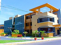
Aguadilla City Hall
-
Banyan Treehouse
-
Campanitas de Cristal Fountain
-
Roman Catholic Parish Church San Carlos Borromeo
-
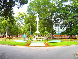
Columbus Cross
-
El Merendero
-
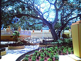
El Parterre
-
Fisherman's Monument
-
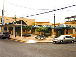
Jardin del Atlántico Sq.
-
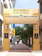
Paseo Miguel Garcia Mendez
-
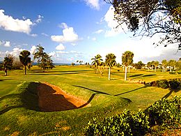
Punta Borinquen Golf Course
-
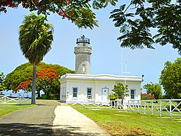
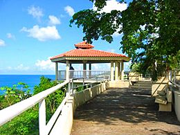
Punta Borinquen Lighthouse
-
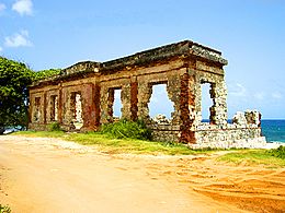
Punta Borinquen Lighthouse Ruins
-
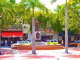
Rafael Hernández Monument
-
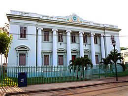
Old Courthouse
-
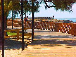
Board Walk
-
Crash Boat Beach
-
Aguadilla Ice Skating Arena


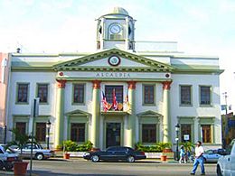
- Aguadilla City Hall - Originally built in 1918. Reconstructed after the 1918 earthquake.
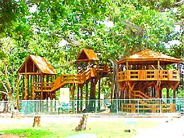
- Banyan Treehouse - Wooden House around a banyan tree. Any of its parts touches the tree.
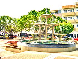
- Campanitas de Cristal Fountain
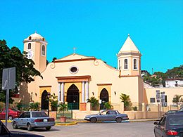
- Cathedral San Carlos Barromeo
- Christopher Columbus Monument - Consists of a cross originally made of marble. It also had to be rebuilt after the earthquake.
- Cristobal Colón Park
- El Merendero
- El Parterre Jose de Jesus Esteves "Ojo de Agua"
- Fisherman's Monument
- Jardin del Atlántico Square
- Las Cascadas (The Waterfalls) Water Park
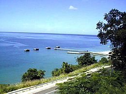
- Old Sugar Pier
- Paseo Miguel Garcia Mendez
- Punta Borinquen Golf Course - Is an 18-hole golf course, originally built for President Dwight D. Eisenhower.
- Punta Borinquen Lighthouse
- Punta Borinquen Lighthouse Ruins
- Rafael Hernández Monument
- Rafael Hernandez Square
- Ramey Skate Park New
- Tribunal Supremo (Old Courthouse)
- Youth Fountain Juan Ponce de León Park
Beaches
- Crash Boat Beach
- La Ponderosa Beach
- La Poza Beach
- La Saldinera Beach
- Surfer's Beach
- Wilderness Beach (Las Ruinas)
- Rompeolas Beach
Culture
Events and festivals
Aguadilla is the site of several yearly celebrations and festivals. The most notable are:
- Velorio de Reyes - Celebrated mostly in January, they are a religious ceremony held as gratitude to the Three Kings for some answered prayer. They usually consist of hymns, prayers, and other religious expressions.
- Kite Festival - Held in April, it includes kiosks, music, and kite flying.
- Fiestas San Antonio - April
- Verbena de Corrales - May
- Beach Festival - June
- Festival del Atún - Celebrated in July, it is a festival dedicated to the fishing of the tuna.
- Festival de la Música - July
- Fiestas Patronales San Carlos - October
Sports
Aguadilla is home to several professional and amateur sports teams. The most notable are the Aguadilla Divas of the Female Superior Volleyball League, and the Aguadilla Sharks of the Superior Baseball League (Double-A). The Divas play their home games in the Luis T. Diaz Coliseum in Downtown Aguadilla from January to March, while the Sharks play their home games at Luis A. Canera Marquez Stadium from February to May.
| Club | League | Sport | Venue |
|---|---|---|---|
| Aguadilla Sharks | Superior Baseball League | Baseball | Luis A. Canera Marquez Stadium |
| Aguadilla Divas | Female Superior Volleyball League | Volleyball | Luis T. Diaz Coliseum |
Aguadilla also had a professional basketball team called the Aguadilla Sharks, that played for the BSN league. This team was merged into the Cangrejeros de Santurce in 1998.
Aguadilla is also a place where many famous baseball players originate from. There are plans for a future ECHL Minor League Hockey franchise for the city.
Demographics
| Historical population | |||
|---|---|---|---|
| Census | Pop. | %± | |
| 1900 | 17,830 | — | |
| 1910 | 21,419 | 20.1% | |
| 1920 | 24,287 | 13.4% | |
| 1930 | 28,319 | 16.6% | |
| 1940 | 34,956 | 23.4% | |
| 1950 | 44,357 | 26.9% | |
| 1960 | 47,864 | 7.9% | |
| 1970 | 51,355 | 7.3% | |
| 1980 | 54,606 | 6.3% | |
| 1990 | 59,335 | 8.7% | |
| 2000 | 64,685 | 9.0% | |
| 2010 | 60,949 | −5.8% | |
| 2020 | 55,101 | −9.6% | |
| U.S. Decennial Census 1899 (shown as 1900) 1910-1930 1930-1950 1960-2000 2010 2016 2020 |
|||
The 1887 census conducted by Spain showed Aguadilla had a population of 16,140.
According to the US 2010 Census, there were 60,949 people in the city. This represents a decrease of more than 3,000 from the 2000 Census. The population density was 1,668.5 inhabitants per square mile (644.2/km2). The 2020 Census indicated the municipality has 55,101 residents representing a decline of over 5,000 residents.
As a whole, Puerto Rico is populated mainly by people from a Creole or Spanish and European descent. Statistics taken from the 2000 census shows that 83.6% of Aguadillanos identify as having Spanish or white origin, 5.0% are black, 0.2% are Amerindian, 0.2% Asian, 0.1% Native Hawaiian/Pacific Islander, 8.2% were Some other race, 2.8% Two or more races.
In March 2012, unemployment was at 16.2%, which is the same percent it was in November 2010.
Religion
Most of Aguadillanos are Christian with a majority being Roman Catholic. Like most cities in Puerto Rico Aguadilla has their Catholic church located on the main square in their downtown. There is also a significant community of Protestants including; Pentecostals, Adventists and Jehovah's Witnesses. Aguadilla has an Islamic community with and Islamic Center located on PR-111 in Palmar barrio.
Transportation

Air
Rafael Hernández Airport is located in the city of Aguadilla. In recent years, it has seen a resurgence as an international airport in the island, with several airlines planning flights to the US from Aguadilla.
Roads
Interstate PR-2 (Rafael Henández Highway). Plans are underway for a new expressway, an expansion to existing Puerto Rico Highway 22 (José de Diego Expressway) from Hatillo and it will probably end at Puerto Rico Highway 111. There are 13 bridges in Aguadilla.
Public
King Face Public Transportation Terminal
Economy
.svg)

The city is currently home to a variety of industrial and pharmaceutical plants like LifeScan, Symmetricom, Honeywell, and Hewlett Packard Enterprise. Most of them are located at San Antonio Technological Park. The airport has Lufthansa Technik, while others like Suiza Dairy, Lockheed Martin and Productos La Aguadillana are located in Camaseyes Industrial Park. Other industries that are based in Aguadilla are rubber, plastics, leather, textiles, steel, wood, machinery, and food processing.
The retail sector is another source of economy in Aguadilla. Shopping malls like Aguadilla Mall, Aguadilla Shopping Center, Aguadilla Town Center, and others are some of the main commercial and retail centers of the city.

In 2019, Aguadilla received the City Livability Award from the United States Conference of Mayors and honored the efforts spearheaded by Carlos Méndez Martínez. Specifically mentioned was "Pintalto", a project where Cerro Cabrero area, in the downtown area of Aguadilla was painted in rich, lively colors.
Tourism

Aguadilla is part of the Porta del Sol touristic region in Puerto Rico. The Porta del Sol website highlights Aguadilla's beaches for surfing.
According to the Department of Natural Resources, Aguadilla has the most beaches in the island, with nineteen. Some of the beaches are considered among the best for surfing, like Surfer's Beach, Gas Chambers, Crash Boat, Wilderness, among others. Because of this, Aguadilla has served as host to surfing competitions, like the ISA World Championship in 1988.
Other attractions of the town are Las Cascadas Water Park and the Aguadilla Ice Skating Arena, which is the only ice skating complex in the Caribbean.
Landmarks and places of interest
There are nine places in Aguadilla listed on the US National Register of Historic Places:
- Old Urban Cemetery
- Casa de Piedra
- District Courthouse (Aguadilla, Puerto Rico)
- El Parterre, Ojo de Agua
- Punta Borinquen Light
- Fuerte de la Concepción
- Iglesia de San Carlos Borromeo - Church San Carlos Barromeo
- Cardona Residence
- López Residence
Other places of interest in Aguadilla include:
- Aguadilla City Hall – originally built in 1918. Reconstructed after the 1918 earthquake.
- Banyan Treehouse – wooden house around a banyan tree (none of its parts touch the tree)
- Campanitas de Cristal, a fountain
- Christopher Columbus Monument – a monument which consists of a cross originally made of marble, and had to be rebuilt after the earthquake.
- Parque Cristobal Colón, a park
- El Merendero
- Fisherman's Monument
- Jardin del Atlántico, a square
- Las Cascadas (The Waterfalls) Water Park (Closed after Hurricane Maria in 2017)
- Old Sugar Pier
- Paseo Miguel Garcia Mendez
- Punta Borinquen Golf Course – an 18-hole golf course, originally built for President Dwight D. Eisenhower.
- Punta Borinquen Lighthouse and ruins
- Rafael Hernández Monument
- Rafael Hernandez Square
- Ramey Skate Park, a skatepark at the Ramey Military Base
- Youth Fountain at Juan Ponce de León Park
To stimulate local tourism during the COVID-19 pandemic in Puerto Rico, the Puerto Rico Tourism Company launched the Voy Turistiendo (I'm Touring) campaign in 2021. The campaign featured a passport book with a page for each municipality. The Voy Turisteando Aguadilla passport page lists Crash Boat Beach, Survival Beach, Rompeolas Beach, and Peña Blanca Beach as places of interest for locals.
Beaches

There are 32 beaches in Aguadilla. Some of the more well known beaches include:
- Balneario Municipal de Aguadilla (GNIS ID 1990599)
- Playa La Ruina (GNIS ID 1991881) also called Wilderness Beach or Las Ruinas ("The Ruins" in English)
- Playa Punta Borinquen (GNIS ID 1991891)
- Crash Boat Beach
- Survival Beach
- Surfer's Beach
- Rompeolas Beach / Rompeolas Beach North also known as Playa Tamarindo
Education
Public schools
In all of the island's municipalities, public education is overseen by the Puerto Rico Department of Education. Aguadilla hosts the Head Start Program for Aguadilla, Aguada, Moca, Rincón, and San Sebastián and a number of private institutions.
As of 2018-2019 the following public schools were operational in Aguadilla:
- Ana M. Javariz is a rural, elementary school, located in Urb. El Prado, offering grades K-6, with about 215 students.
- Antonio Badillo Hernandez is a rural, elementary school, located in Montaña, offering grades K-6, with about 327 students.
- Homero Rivera Sola is a rural, elementary school, located in Corrales barrio, offering grades K-6, with about 153 students.
- Jose de Diego is a rural, elementary school, located in Res. Jose de Diego, offering grades K-6, with about 242 students.
- Luis Muñoz Rivera is a rural, elementary school, located in Camaseyes barrio, offering grades K-6, with about 206 students.
- Antonio Badillo Hernandez is a rural, intermediate school, located in Montaña barrio, offering grades 7–9, with about 336 students.
- Ester Feliciano Mendoza is a rural, intermediate school offering grades 6–8, with about 416 students.
- Benito Cerezo Vazquez is a rural, high school, located in Borinquen barrio, offering grades 10–12, with about 435 students.
- Juan Suarez Pelegrina is a rural, high school, located in Montaña barrio, offering grades 10–12, with about 715 students.
- Salvador Fuentes is a rural, high school, located in Ramey base, offering grades 10–12, with about 288 students.
- Centro de Adiestramiento y Bellas Artes (CABA) is a school that specializes in the arts, located in Ramey base. In 2016, it served about 500 students.
- Su Conchita Iguartua de Suarez is a rural, elementary school offering grades Pre-8, with about 768 students.
Higher education
Aguadilla hosts the following universities:
- Puerto Rico Aviation Maintenance Institute
- Aeronautical and Aerospace Institute of Puerto Rico (AAIPR)
- University of Puerto Rico (UPR), Aguadilla Campus
- Metropolitan University, Aguadilla Campus
- Inter American University of Puerto Rico, Aguadilla Campus
- Automeca Technical College
- Puerto Rico Criminal Justice College, Aguadilla Campus (Puerto Rico Police Academy) Ramey Job Corps also serves those who want to attain a higher education.
Aguadilla Library System
There is a library in San Antonio Village and another in downtown Aguadilla (Aguadilla barrio-pueblo).
Notable people from Aguadilla
Due to space limitations it is almost impossible to list all of the people of Aguadilla who have distinguished themselves, therefore a category has been created to this effect:
Images for kids
-
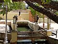
The Ojo de Agua or water spring which gives the municipality one of its nicknames.
-
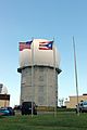
FAA radar tower in Aguadilla, Puerto Rico
-
Sign for former train station in Aguadilla
-
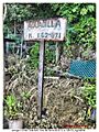
Cuesta Vieja, a sector of Aguadilla, where the train derailed
-
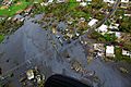
Aerial view of Aguadilla a few days after Hurricane Maria
-
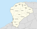
Barrios of Aguadilla
-
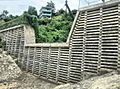
A structure is used for flood-control in Sector La Via, a Special Community in Aguadilla.
-
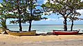
Near Schoolyards Beach
-
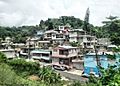
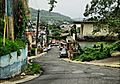
Cerro Echevarría Sector, Aguadilla barrio-pueblo


.jpg)


See also
 In Spanish: Aguadilla para niños
