
Ainaro Municipality facts for kids
Quick facts for kids
Ainaro
Ainaru
|
||
|---|---|---|

Maubisse village
|
||
|
||

Map of East Timor highlighting Ainaro Municipality
|
||
| Country | ||
| Capital | Ainaro | |
| Area | ||
| • Total | 802 km2 (310 sq mi) | |
| Population
(2015)
|
||
| • Total | 63,136 | |
| • Density | 78.72/km2 (203.89/sq mi) | |
| ISO 3166 code | TL-AN | |

Ainaro is a municipality of East Timor. Its capital is the city of Ainaro.
Ainaro has the highest point in East Timor, Mount Ramelau (2,960 m).
Administrative posts
The municipality's administrative posts (formerly sub-districts) are:
- Ainaro Administrative Post (place of capital)
- Hato-Udo Administrative Post
- Hatu-Builico Administrative Post
- Maubisse Administrative Post
Images for kids
-
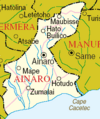
Borders of Ainaro before 2003
-
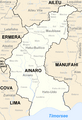
Borders of Ainaro after 2003
-
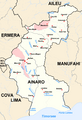
Cities and rivers of Ainaro


See also
 In Spanish: Distrito de Ainaro para niños

All content from Kiddle encyclopedia articles (including the article images and facts) can be freely used under Attribution-ShareAlike license, unless stated otherwise. Cite this article:
Ainaro Municipality Facts for Kids. Kiddle Encyclopedia.