
Southeast Alaska facts for kids

Southeast Alaska, colloquially referred to as the Alaska Panhandle or Alaskan Panhandle, is the southeastern portion of the U.S. state of Alaska, bordered to the east by the northern half of the Canadian province of British Columbia. The majority of Southeast Alaska's area is part of the Tongass National Forest, the United States' largest national forest. In many places, the international border runs along the crest of the Boundary Ranges of the Coast Mountains (see Alaska boundary dispute). The region is noted for its scenery and mild, rainy climate.
The largest cities in the region are Juneau, Sitka, and Ketchikan. This region is also home to the easternmost town in Alaska, Hyder.
Contents
Geography
Southeast Alaska is the northern terminus of the Inside Passage, a protected waterway of convoluted passages between islands and fjords, beginning in Puget Sound in Washington state. This was an important travel corridor for Tlingit and Haida Native peoples, as well as gold-rush era steamships. In modern times it is an important route for Alaska Marine Highway ferries as well as cruise ships. Southeast Alaska has a land area of 35,138 square miles (91,010 km2) comprising seven entire boroughs and two census areas, in addition to the portion of the Yakutat Borough lying east of 141° West longitude. Although it has only 6.14 percent of Alaska's land area, it is larger than the state of Maine, and almost as large as the state of Indiana. The Southeast Alaskan coast is roughly as long as the west coast of Canada. The 2010 census population of Southeast was 71,616 inhabitants, about 45 percent of whom were concentrated in the city of Juneau.
- Haines Borough
- Hoonah-Angoon Census Area
- Juneau Borough
- Ketchikan Gateway Borough
- Petersburg Borough
- Prince of Wales-Hyder Census Area
- Sitka Borough
- Skagway Borough
- Wrangell Borough
- Yakutat Borough (the part east of 141° W longitude; 12,506.53 km2 / 4,828.80 sq mi, or about 63.12 percent of the borough)
It includes the Tongass National Forest (which manages Admiralty Island National Monument and Misty Fjords National Monument), Glacier Bay National Park, Sitka National Historical Park, Alaska's Inside Passage, and myriad large and small islands. The largest islands are, from North to South, Chichagof Island, Admiralty Island, Baranof Island, Kupreanof Island, Revillagigedo Island and Prince of Wales Island. Major bodies of water of Southeast Alaska include Glacier Bay, Lynn Canal, Icy Strait, Chatham Strait, Stephens Passage, Frederick Sound, Sumner Strait, and Clarence Strait.
On August 20, 1902, President Theodore Roosevelt established the Alexander Archipelago Forest Reserve, which formed the heart of the Tongass National Forest that covers most of the region.
National parks and monuments
- Glacier Bay National Park and Preserve
- Klondike Gold Rush National Historical Park
- Sitka National Historical Park
- Wrangell-St. Elias National Park and Preserve (part, the southeasternmost section only)
- Admiralty Island National Monument
- Misty Fjords National Monument
Ecology
Southeast Alaska is a temperate rain forest within the Pacific temperate rain forest zone, as classified by the World Wildlife Fund's ecoregion system, which extends from northern California to Prince William Sound. The most common tree species are sitka spruce and western hemlock. Wildlife includes brown bears, black bears, the endemic Alexander Archipelago wolf, Sitka black-tailed deer, humpback whales, orcas, five species of salmon, bald eagles, harlequin ducks, scoters, and marbled murrelets.
The Ecological Atlas of Southeast Alaska, published by Audubon Alaska in 2016, offers an overview of the region's landscape, birds, wildlife, human uses, climate change, and more, synthesizing data from agencies and a variety of other sources.
Cities and towns
Major cities are Juneau, Ketchikan, and Sitka. Other towns are Petersburg, Wrangell, Metlakatla, Haines, Hoonah, Angoon, Kake, Craig, Klawock, Thorne Bay, Yakutat, Skagway, and Gustavus. There are also many towns and villages with around 100 people, such as Baranof Warm Springs, Edna Bay, Elfin Cove, Excursion Inlet, Funter Bay, Meyers Chuck, Pelican, Port Alexander, Port Frederick, Port Protection, and Tenakee Springs. This region is also home to the easternmost town in Alaska, Hyder.
Culture

This area is the traditional homeland of the Tlingit, and home of a historic settling of Haida as well as a modern settlement of Tsimshian. The region is closely connected to Seattle and the American Pacific Northwest economically and culturally.
In modern times, southeastern Alaskans can often be identified by their fashion choices, notably Xtratuf boots, and "shirtjacs" (a garment having aspects of both shirt and jacket).
History
The border between the Canadian province of British Columbia and Alaska is known as the Alaska boundary dispute, where the United States, Canada and the United Kingdom and British Columbia claimed different borderlines at the Alaskan Panhandle. While the British foreign affairs were in favour of support of the Canadian argument, the event resulted in what was thought of as a betrayal, leading to alienation of the British from the new nation of Canada.
Historian Patricia Roppel authored thirteen books and more than 100 articles on the region.
Transportation

Due to the extremely rugged, mountainous nature of Southeastern Alaska, almost all communities (with the exception of Hyder, Skagway, and Haines) have no road connections outside of their locale, so aircraft and boats are the major means of transport. The Alaska Marine Highway passes through this region.
Air transportation
Alaska Airlines is by far the largest air carrier in the region, with Juneau's Juneau International Airport serving as the aerial hub for all of Southeast and Ketchikan's Ketchikan International Airport serving as a secondary hub for southern Southeast Alaska. Alaska's bush airlines and air taxis serve many of the smaller and more isolated communities and villages in the regions. Many communities are accessible by air only by floatplane, as proper runways are often difficult to construct on the steep island slopes.
Marine transportation
Southeast Alaska is primarily served by the state-run Alaska Marine Highway, which links Skagway, Haines, Hoonah, Juneau, Sitka, Petersburg, Wrangell, Ketchikan and other outlying communities with Prince Rupert, BC and Bellingham, Washington; and secondarily by the Prince of Wales Island-based Inter-Island Ferry Authority, which provides the only scheduled passenger and auto ferry service to the island. A new Authority, the Rainforest Islands Ferry Authority, was created and in 2014 may possibly operate the North End route. The Authority would connect Coffman Cove with Wrangell and Petersburg. Small companies like Sitka-based Allen Marine and other independent operators in the Lynn Canal occasionally also offer marine passenger service. Ship traffic in the area is seasonally busy with cruise ships.
Demographics

.jpg)
Southeast Alaska is composed of seven entire boroughs and two census areas, in addition to the portion of the Yakutat Borough lying east of 141° West longitude. Although it has only 6.14 percent of Alaska's land area, it is larger than the state of Maine, and almost as large as the state of Indiana. The Southeast Alaskan coast is roughly as long as the west coast of Canada.
The 2010 census population of Southeast Alaska was 71,616 inhabitants, representing approximately 10% of the state's total population. About 45% of residents in the Southeast Alaska region were concentrated in the city of Juneau, the state capital. As of 2018, the number of settlements in Southeast Alaska that have a population of at least 1,000 people has grown to nine.
Boroughs
- Haines Borough
- Hoonah-Angoon Census Area
- Juneau Borough
- Ketchikan Gateway Borough
- Petersburg Borough
- Prince of Wales-Hyder Census Area
- Sitka Borough
- Skagway Borough
- Wrangell Borough
- Yakutat Borough (the part east of 141° W longitude; 12,506.53 km2 / 4,828.80 sq mi, or about 63.12 percent of the borough)
Major cities and towns
Populations are taken from the 2020 Census.
- Juneau - 32,255 inhabitants
- Sitka - 8,458 inhabitants
- Ketchikan - 8,192 inhabitants
- Petersburg - 3,043 inhabitants
- Wrangell - 2,127 inhabitants
- Haines - 1,657 inhabitants
- Metlakatla - 1,454 inhabitants
- Skagway - 1,240 inhabitants
- Craig - 1,036 inhabitants
Images for kids
-

Southeast Alaska highlighted on a map
-
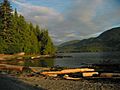
The Tongass National Forest, near Ketchikan
-
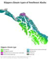
Köppen climate types in southeast Alaska


See also
 In Spanish: Mango de Alaska para niños
