
Albany, Oregon facts for kids
Quick facts for kids
Albany, Oregon
|
||
|---|---|---|

Looking west down 1st Avenue SW in downtown Albany
|
||
|
||
| Nickname(s):
Hub of the Valley Grass Seed Capital Rare Metals Capital
|
||
| Motto(s):
The center of the Willamette Valley; the heart of Oregon
|
||

Location in Oregon
|
||

Albany, Oregon
Location in Oregon

Albany, Oregon
Location in the United States

Albany, Oregon
Location in North America
|
||
| Country | United States | |
| State | Oregon | |
| Counties | Linn, Benton | |
| Incorporated | 1864 | |
| Government | ||
| • Type | Council-Manager | |
| Area | ||
| • City | 17.87 sq mi (46.28 km2) | |
| • Land | 17.66 sq mi (45.75 km2) | |
| • Water | 0.21 sq mi (0.54 km2) | |
| • Urban | 21.7 sq mi (56 km2) | |
| Elevation | 210 ft (60 m) | |
| Population
(2020)
|
||
| • City | 56,472 | |
| • Density | 3,160.2/sq mi (1,220.22/km2) | |
| • Urban | 56,997 (US: 459th) | |
| • Metro | 118,765 (US: 315th) | |
| Time zone | UTC−8 (Pacific) | |
| • Summer (DST) | UTC−7 (Pacific) | |
| ZIP codes |
97321-97322
|
|
| Area codes | 541, 458 | |
| FIPS code | 41-01000 | |
| GNIS feature ID | 1116796 | |

Albany is the county seat of Linn County, and the 11th largest city in the U.S. state of Oregon. Albany is located in the Willamette Valley at the confluence of the Calapooia River and the Willamette River in both Linn and Benton counties, just east of Corvallis and south of Salem. It is predominantly a farming and manufacturing city that settlers founded around 1848. As of the 2020 United States Census, the population of Albany was 56,472.
Albany has a home rule charter, a council–manager government, and a full-time unelected city manager. The city provides the population with access to over 30 parks and trails, a senior center, and many cultural events such as the Northwest Art & Air Festival, River Rhythms, Summer Sounds and Movies at Monteith. In addition to farming and manufacturing, the city's economy depends on retail trade, health care, and social assistance. In recent years the city has worked to revive the downtown shopping area, with help from the Central Albany Revitalization Area.
Contents
History
In the historic era, the area of the Willamette Valley that makes up modern-day Albany was inhabited by one of the tribes of the Kalapuya a Penutian-speaking, Native American people. The Kalapuya had named the area Takenah, a Kalapuyan word used to describe the deep pool at the confluence of the Calapooia and Willamette rivers. A variation of the place name can also be written as Tekenah.
The Kalapuya population in the valley was between 4,000 and 20,000 before contact with Europeans, but they suffered high mortality from new infectious diseases introduced shortly afterward. The tribes were decimated by a smallpox epidemic that raged through the Pacific Northwest in 1782–83. A malaria outbreak swept through the region between 1830 and 1833. It is estimated that as many as 90 percent of the Kalapuya population died during this period. That, coupled with the treaties signed during the 1850s by the Kalapuya to cede land to the United States, left the area nearly free for European Americans to settle.
The first European American settler arrived in 1845; Abner Hackleman was a farmer from Iowa. Taking up a land claim for himself, Hackleman asked Hiram N. Smead to hold another for him until his son arrived from Iowa. In 1846, a year after arriving in Oregon, Hackleman died while returning to Iowa to fetch his family. In 1847 a pair of brothers, Walter and Thomas Monteith, settled in the area, after traveling by ox team along the Oregon Trail from their native state of New York. They were a family of early prominence in the area; in 1848, they bought a claim of 320 acres (1.3 km2) from Hiram Smead for $400 and a horse; they plotted out 60 acres (240,000 m2) for the town site. They named the city "Albany" after their hometown of Albany in New York. During the same period, Hackleman's son Abram reached his father's original land claim and built a log house in an oak grove still known as Hackleman's Grove. He later built a house, which still stands at the corner of Fifth and Jackson. The small settlement that formed on the Hackleman land became known as the community of Takenah in 1849.

During this early period, the Monteith and Hackleman families were literally and politically on opposite sides of the fence. Residents in the Monteiths' portion of town were mainly merchants and professionals, who aligned with the Republican Party. They tended to sympathize with the Union during the Civil War. The residents in Hackleman's portion of town to the east were made up mostly of working-class Democrats who sided with the Confederacy. The two sides planted a hedge near Baker Street separating their sides of town.
With help from Samuel Althouse, the Monteiths built the first frame house in Albany in 1849. The Monteith House was considered the finest house in Oregon at the time. That same year the start of the California Gold Rush had caught the attention of the Monteith brothers, who provided supplies to the gold fields; their profits were seed money for several new businesses in Albany, including the general store. After the Monteiths developed these businesses, Albany became a major hub city in the Willamette Valley.
Albany's first school was established in 1851 by the town's first physician, R. C. Hill. The first school teacher was Eleanor B. Hackleman, wife of Abram Hackleman. It was not until 1855 that a building was specifically erected for use as a school. In 1852, the first steamboat, the Multnomah, arrived and the first flour mill was built.

On January 8, 1850, a U.S. post office was established in Albany, with John Burkhart appointed as the first U.S. Postmaster. The town was renamed as "New Albany" on November 4, 1850, but the name was changed back to Albany in 1853. In 1851, Albany was designated as the county seat, replacing Calapooia (near modern-day Brownsville and Sweet Home), and all court meetings were held there. The first Albany courthouse was built in 1852 on 10 acres (4.0 ha) of land donated by the Monteiths to ensure Albany would remain the county seat. The new two-story octagonal courthouse was completed on April 26, 1853. The courthouse has since been replaced, but the new courthouse stands on the same site.
During 1853–1854, residents of the east side of Albany persuaded the Oregon Legislative Assembly to name both towns Takenah. Though Takenah meant "deep pool," in reference to the confluence of the Calapooia and Willamette rivers, it was commonly translated as "Hole in the Ground". Partially due to this translation, the legislature restored the name Albany to the town in 1855. Finally in 1864, 16 years after the Monteiths founded the town and 19 years after the first European Americans arrived, it became incorporated as a city.
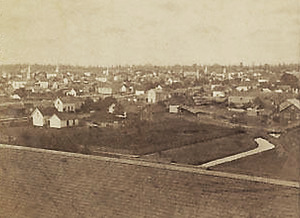
.jpg)
In 1871, the trains first reached Albany, connecting it to other towns in the valley. The arrival of the first train was celebrated as the greatest event in Albany's history. Albany businessmen raised $50,000 to ensure that the rails would be built through the city, instead of bypassing it a few miles eastward. The train brought the farmers' markets closer to the city, as stagecoaches and steamboats gave way to the railroad. The world's longest wooden railroad drawbridge was built in 1888 for the Albany-Corvallis run. By 1910, 28 passenger trains departed daily from Albany going in five directions.
In 1872, the Santiam Ditch and Canal Company was organized, and a canal running from the Santiam near Lebanon was completed that autumn. The canal runs 18 miles (29 km) from the south side of Albany and divides at the corner of Vine and Eight streets, with one branch running down Vine Street and emptying into Calapooia Creek, with a drop of 32 feet (9.8 m). The other runs down Eighth to Thurston Street.
In 1924 Pacific Power installed a turbine where the canal meets the river to generate electricity. In 1984 the city bought the water system from Pacific Power, and shut down the plant in 1991. By 2003 the city had approved a plan to restart the four megawatt-hour hydroelectric plant and in February 2009 the plant opened again. Albany was the headquarters for the Mountain States Power Company from its establishment in 1918 until its merger into Pacific Power & Light (now PacifiCorp) in 1954.
In the 1940s, the city started the Albany World Championship Timber Carnival, which drew competitors from all over the world to participate in logging skills contests. The event took place over the four days of the Fourth of July weekend. Men and women would compete in climbing, chopping, bucking, and burling contests. In 2001 the carnival was cancelled because of smaller crowds and the state’s declining timber economy.
In 1916 Kuo-Ching Li, a Chinese-American engineer, founded Wah Chang Trading Corporation in New York State, but it was based in Albany. He developed it as an international tungsten ore and concentrate trading company, leading the company until his death in 1961. He served as president until 1960 and then board chairman.
The U.S. Bureau of Mines established a research center on the former Albany College campus in 1942, focusing on the development of new metallurgical processes. First known as the Northwest Electro-development Facility, the site produced titanium and zirconium. It fostered the growth of a new rare metals industry in Albany, led by internationally recognized companies such as the Oregon Metallurgical Company, Oremet, and Wah Chang. In the 1970s, Albany attempted to extend its city limits to include a zirconium processing plant of Wah Chang Corporation in order to increase its industrial tax base. Wah Chang responded in 1974 by sponsoring a vote to incorporate the desired properties as Millersburg. When the Bureau of Mines closed in 1996, the facility was transferred to the United States Department of Energy's Office of Fossil Energy. In 2005 the facility became part of the National Energy Technology Laboratory.
Geography

Albany is in the central part of Oregon's most populated region, the Willamette Valley. The city rests along the confluence of the Calapooia and Willamette rivers, and although most of Albany falls within Linn County, a smaller portion of the city rests to the north of its downtown on the west bank of the Willamette River in Benton County.
According to the United States Census Bureau, the city has a total area of 17.75 square miles (45.97 km2), of which 17.54 square miles (45.43 km2) is land and 0.21 square miles (0.54 km2) is water. Albany has 21.7 square miles (56 km2) within its urban growth boundary. Throughout the city limits and urban growth area, there are limited hills; the city is one of the lowest points along the Willamette Valley, with elevations ranging 180 to 430 feet (55 to 131 m) above sea level. The North Albany District has the most variable elevation, while the downtown and southern end of town have little elevation change throughout.
 |
Salem | Jefferson | |
|
| Corvallis | Tangent | Lebanon |
Climate
Similar to the majority of Oregon, Albany's weather is considered to be mild. Albany has generally warm and dry summers during which precipitation drops to 0.4 inches (10 mm) in July and temperatures peak at an average of 80.8 °F (27 °C) in August. The record high temperature in Albany was 108 °F (42 °C) in 1981. Winters in Albany are cool and wet. The month with the most precipitation is December with 6.8 inches (170 mm). The coldest month is January with an average low just above freezing at 33.6 °F (1 °C). The record low temperature was recorded in 1972 at −7 °F (−22 °C).
Albany and the surrounding area was left devastated by the Columbus Day Storm in October 1962.
| Climate data for Albany, Oregon | |||||||||||||
|---|---|---|---|---|---|---|---|---|---|---|---|---|---|
| Month | Jan | Feb | Mar | Apr | May | Jun | Jul | Aug | Sep | Oct | Nov | Dec | Year |
| Average high °F (°C) | 46.2 (7.9) |
52.6 (11.4) |
56.5 (13.6) |
60.2 (15.7) |
68.4 (20.2) |
73.7 (23.2) |
80.6 (27.0) |
80.8 (27.1) |
75.8 (24.3) |
64.7 (18.2) |
53.5 (11.9) |
46.5 (8.1) |
63.3 (17.4) |
| Average low °F (°C) | 33.6 (0.9) |
34.4 (1.3) |
35.5 (1.9) |
37.7 (3.2) |
42.7 (5.9) |
48.6 (9.2) |
50.6 (10.3) |
50.7 (10.4) |
46.9 (8.3) |
41.0 (5.0) |
38.6 (3.7) |
34.5 (1.4) |
41.2 (5.1) |
| Average precipitation inches (mm) | 6.4 (160) |
5.3 (130) |
4.3 (110) |
2.6 (66) |
2.2 (56) |
1.4 (36) |
0.4 (10) |
0.5 (13) |
1.7 (43) |
3.4 (86) |
6.2 (160) |
6.8 (170) |
41.1 (1,040) |
| Source: Weatherbase | |||||||||||||
Demographics
| Historical population | |||
|---|---|---|---|
| Census | Pop. | %± | |
| 1870 | 1,292 | — | |
| 1880 | 1,867 | 44.5% | |
| 1890 | 3,079 | 64.9% | |
| 1900 | 3,149 | 2.3% | |
| 1910 | 4,275 | 35.8% | |
| 1920 | 4,840 | 13.2% | |
| 1930 | 5,325 | 10.0% | |
| 1940 | 5,654 | 6.2% | |
| 1950 | 10,115 | 78.9% | |
| 1960 | 12,926 | 27.8% | |
| 1970 | 18,181 | 40.7% | |
| 1980 | 26,546 | 46.0% | |
| 1990 | 29,462 | 11.0% | |
| 2000 | 40,852 | 38.7% | |
| 2010 | 50,158 | 22.8% | |
| 2020 | 56,472 | 12.6% | |
| Source:
2018 Estimate |
|||
2010 census
As of the census of 2010, there were 50,158 people, 19,705 households, and 12,894 families residing in the city. The population density was 2,859.6 inhabitants per square mile (1,104.1/km2). There were 20,979 housing units at an average density of 1,196.1 per square mile (461.8/km2). The racial makeup of the city was 87.8% White, 0.7% African American, 1.2% Native American, 1.4% Asian, 0.2% Pacific Islander, 5.2% from other races, and 3.6% from two or more races. Hispanic or Latino of any race were 11.4% of the population.
There were 19,705 households, of which 33.7% had children under the age of 18 living with them, 47.8% were married couples living together, 12.4% had a female householder with no husband present, 5.2% had a male householder with no wife present, and 34.6% were non-families. 26.7% of all households were made up of individuals, and 9.9% had someone living alone who was 65 years of age or older. The average household size was 2.50 and the average family size was 3.01.
The median age in the city was 35.6 years. 25% of residents were under the age of 18; 9.6% were between the ages of 18 and 24; 27.4% were from 25 to 44; 24.7% were from 45 to 64; and 13.1% were 65 years of age or older. The gender makeup of the city was 48.8% male and 51.2% female.
Economy

Albany calls itself the "rare metals capital of the world", producing zirconium, hafnium and titanium. One of the major producers of these metals in Albany is ATI Specialty Alloys and Components (formerly ATI Wah Chang) which has a 110-acre (0.45 km2) site that primarily focuses on the production of zirconium.
Albany and the surrounding communities are major exporters of grass seed. Other crops produced include corn, beans, mint, strawberries, and hazelnuts. Linn County is also referred to as the "Grass Seed Capital of the World".
The decline of the timber industry and the outsourcing of manufacturing jobs has left Linn County with a relatively high unemployment rate. The Oregon Employment Department does not maintain unemployment statistics for cities. The losses in the timber industry in around Albany have led the city to a more diverse economic base for the city, led by retail trade, health care and social assistance, and manufacturing as the three leading aspects of the economy. Oregon Freeze Dry is a leading employer in the manufacturing sector of the Albany economy with its headquarters located in the city. The company employs over 300 people and was incorporated in 1963. The Albany facility is the company's main research and development site in the industry, and has recently partnered with Seattle-based technology company EnerG2 to produce carbon electrode material, in a 74,000-square-foot (6,900 m2) former distribution center of Oregon Freeze Dry by 2011 bringing a new green technology industry to Albany. Tec Laboratories has made Tecnu poison ivy cleanser and other topical medicines in Albany since 1977.
Albany is also home to the Albany Research Center, which is part of National Energy Technology Laboratory (NETL). They employ a staff of 120. Albany Research Center was founded in 1943, the laboratory specializes in life cycle research starting with the formulation, characterization, and/or melting of most metals, alloys, and ceramics; casting and fabrication, prototype development; and the recycle and remediation of waste streams associated with these processes.
Albany has a per capita income of $18,570, putting it ranked at 81st in the state.
Education


Albany is the home of a two-year junior college called Linn-Benton Community College, which was established in 1966. The college offers certificates and associate degrees and has many transfer and dual enrollment programs with OSU (through a degree partnership program) totaling over 60 programs of study. LBCC serves over 24,000 full- and part-time students in and around Albany and is supported financially through tuition, property taxes and the State of Oregon.
The Albany area has also been served since 1979 by the Greater Albany Public School District, including West Albany High School, and South Albany High School, which have a combined enrollment of approximately 2,700 students. Albany is also served by Albany Options School as an alternative to traditional school for grades 6 through 12. In total Greater Albany Public School District serves roughly 8,900 students throughout its 23 different schools. Along with the K-12 schools Albany also offers student services at the Maple Lawn Preschool.
| Name | Current campus | Enrollment (2009–10) | Nickname |
|---|---|---|---|
| South Albany High School | 1970 | 1,270 | RedHawks |
| West Albany High School | 1953 | 1,450 | Bulldogs |
The Albany Collegiate Institute was founded in 1867 and served as Albany's higher education institute for 70 years before it was moved to Portland, Oregon, and renamed Lewis & Clark College.
Infrastructure

.jpg)


Transportation
Highway
Albany is adjacent to Interstate 5, while Oregon Route 99E runs through it in a north and south direction and U.S. Route 20 runs through it in an east and west direction. Just outside the south end of Albany Oregon Route 34 runs from east to west.
Air
Albany Municipal Airport is a general aviation airport on the eastern edge of Albany and has been open since 1920 and is believed to be the oldest operating airfield in Oregon. In 1998, the airport became the first airport in Oregon to be named to the National Register of Historic Places, and was the City of Albany's fourth National Historic District, It held its first air show in 1931 and has been home to exhibits, helicopter rides and Young Eagles flights for children as part of the annual Northwest Art & Air Festival. It has a single runway with the specs of 16–34 3,004 X 75, and is an asphalt runway. The closest airports with commercial air service available are the Eugene Airport to the south and the Portland International Airport to the north.
Bus
Public transportation within Albany is provided by Albany Transit System (ATS). Connections to Corvallis are provided by bus service via the Linn-Benton Loop and the Valley Retriever Thruway inter-county bus systems. ATS, the Linn-Benton Loop, and the Valley Retriever all provide bus service to and from the Amtrak station.
Train
Amtrak, the national passenger rail system, provides service to Albany from its Albany Station at 10th Avenue SW on two routes. Long-haul train route the Coast Starlight (with service from Los Angeles to Seattle) stops in Albany daily in both directions. Amtrak Cascades commuter trains operate between Vancouver, British Columbia and Eugene, Oregon, and serve Albany several times daily in each direction. The Amtrak Cascades line is the proposed path of the Pacific Northwest Corridor high-speed rail line. The Albany station would be one of many stops along the proposed 466-mile (750 km), 110-mile-per-hour (180 km/h) passenger line.
The station itself was constructed in 1909 for the Southern Pacific Railroad and is built of masonry. It is one of the oldest continuously operating passenger rail stations in the U.S. and has one of the best-equipped engine shops in the northwest. Southern Pacific 4449, a steam locomotive which resides at the Oregon Rail Heritage Center in Portland, occasionally visited the shop for repairs when it was residing at the Brooklyn Roundhouse in Portland (before 2012), as did several other locomotives stored at the now-demolished roundhouse. Beginning in 2004, the station and the surrounding area underwent an $11.3 million restoration that was funded with a combination of federal, state, local, and Amtrak money. In 2006 the city received the Award in Downtown Excellence from the Oregon Downtown Development Association for the renovation of the station.
Bridges
Albany has both the Ellsworth Street Bridge which was constructed in 1926 and the Lyon Street Bridge that was constructed in 1973. They are both two-lane bridges that make up part of U.S. Route 20. The two bridges connect Linn to the south with Benton county in the north as they pass across the Willamette River. this makes up the major connection of downtown Albany with the north end of town and to Corvallis.
Paths and trails
Albany has many paths and trails open to both pedestrian and bicyclists. Simpson Park Trail is a dirt pedestrian trail with a round trip distance of 2.36 miles (3.80 km). The dirt trail starts at the parking lot of Simpson Park and continuing until the path ends in a grassy area with one very narrow path heading back toward the river. Periwinkle Creek Trail though is the longest of all the paved trails. It is a flat bicycle and pedestrian path that runs along Periwinkle Creek from the northwest corner of Grand Prairie Park to the Albany Boys and Girls Club, and travels a round trip distance of 3.61 miles (5.81 km). There are many other trails throughout the city to include, Cox Creek Loop and Waverly Lake Loop, Dave Clark Trail, Oak Creek Greenbelt Trail, Takena Landing Trail, Timber Linn Park Trails, and a proposed Swanson Park Connector a paved path on the north side of highway 99 that connects Swanson Park with the nearby Amtrak/Transit Center.
Albany has made a growing effort to increase itself as a bicyclist friendly town through increasing the number of paths and trails that are open to them. The city was recently recognised as a Bicycle-Friendly Community for 2010 by the League of American Bicyclists for its efforts.
Notable people

- Jerry Andrus (1918–2007) – magician
- Mike Barrett (born 1968) – TV announcer of the NBA
- Charles B. Bellinger (1839–1905) – federal district court judge, editor of the State Rights Democrat (Now the Albany Democrat-Herald)
- Dyrol Burleson 1500m Olympian
- George Earle Chamberlain (1854–1928) – 11th Governor of Oregon
- Daveigh Chase (born 1990) – actress
- Abigail Scott Duniway (1834–1915) – writer, newspaper publisher, and women's rights advocate
- Members of Falling Up – Christian rock band
- Alan L. Hart (1890–1962) – physician and novelist, was raised in Albany
- Dave Johnson (born 1963) – Olympic athlete and former West Albany High School teacher
- Percy R. Kelly (1870–1949) – American attorney and jurist in the state of Oregon
- Frank Morse (born 1943) – politician
- Sam Shoen (1916–1999) – founder of U-Haul Corp., operated a barbershop in the St. Francis Hotel at First Ave. and Calapooia St. while a student at Oregon State College in the early 1940s
- Delazon Smith (1816–1860) – politician
- Elmo Smith (1909–1968) – 27th Governor of Oregon
- James K. Weatherford (1850–1935) – Speaker of the Oregon House of Representatives (1876) and State Senator
- Mae Yih (born 1928) – member of the Oregon Legislative Assembly
Images for kids
-
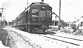
An Oregon Electric Railway train passing through Albany, Oregon, c. 1910s
-
Thomas and Walter Monteith House
-
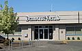
Democrat-Herald offices on Lyon Street
.jpg)


See also
 In Spanish: Albany (Oregón) para niños
