
Alexandra Canal (New South Wales) facts for kids
Quick facts for kids Alexandra Canal |
|
|---|---|

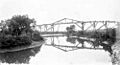
Alexandra Canal, looking upstream towards the Sydney CBD
|
|

Location of the mouth in Greater Sydney
|
|
| Other name(s) | Shea's Creek |
| Country | Australia |
| State | New South Wales |
| Local government areas |
|
| Physical characteristics | |
| Main source | Sydney Park Alexandria 1.5 metres (4 ft 11 in) AHD 33°54′37″S 151°11′29″E / 33.91028°S 151.19139°E |
| River mouth | Cooks River Tempe 0.5 metres (1 ft 8 in) AHD 33°55′59″S 151°9′43″E / 33.93306°S 151.16194°E |
| Length | 4.5 kilometres (2.8 mi) |
| Width |
|
| Basin features | |
| River system | Cooks River |
| Bridges |
|
| Type: | Built |
| Criteria: | a., c., d., e., f., g. |
| Designated: | 15 November 2002 |
| Reference #: | 01621 |
The Alexandra Canal, a tributary of the Cooks River, is a heritage-listed artificial waterway in southern Sydney, New South Wales, Australia. Alexandra Canal was named after Princess Alexandra, who married Edward, Prince of Wales (later King Edward VII) in 1863.
The canal is Sydney's first inbound waterway. It stretches 4 kilometres (2.5 mi) from the inner Sydney suburb of Alexandria, flowing through the suburbs of St Peters and Mascot, past Sydney's Sydney Airport to the Cooks River at Tempe, which eventually discharges into Botany Bay. The canal is 60 metres (200 ft) wide, increasing to 80 metres (260 ft) at its mouth. and is one of only two navigable canals constructed in New South Wales.
History
Early industry used Shea's Creek for drainage and complaints by the public were often aired to the government with requests for a solution.
Alexandra Canal was once a salt marsh known as Shea's Creek. Excavation began in 1887 to transform the marshland into a canal capable of carrying barges to transport goods from the nearby brickworks, woollen mills, tanneries and foundries.
During the excavation of Shea's Creek in 1896, the remains of a dugong were found in the estuarine clay. Examination by the then curator of the Australian Museum, Robert Etheridge, revealed the animal had been butchered by a blunt-edged cutting or chopping instrument. Two stone hatchet heads were found nearby. The artifacts provide evidence of the Indigenous Australians who lived in the area prior to European settlement.
Construction of Alexandra Canal provided employment for workers during the depression of the 1890s. The original plan was for the canal to continue all the way to Sydney Harbour, but this did not eventuate, and construction of the canal ceased in 1900.
During World War II, 250 wool sheds were constructed along the eastern side of the canal, built as temporary storage for the large amounts of wool stockpiled during the war. Some of these sheds still exist today.
In the 19th and 20th centuries, the canal became highly polluted by runoff from nearby industries, with the canal's sediment contaminated with heavy metals. In 1998, Sydney Water launched a A$4 million plan to clean and restore the condition of the canal's water, but this plan has since been abandoned. Five tributaries flow into the canal.
Redevelopment proposal
In June 1998, the then New South Wales Minister for Urban Affairs and Planning, Craig Knowles, announced that architecture students from the University of New South Wales would be commissioned to create designs that would transform Alexandra Canal into a "stunning water and green recreation corridor between Sydney Harbour and Botany Bay". The students were given an A$5000 grant, funded by the South Sydney Development Corporation, an authority owned by the Government of New South Wales to oversee the redevelopment of the Green Square precinct. Nine of the students' designs were put on public exhibition in August that year.
By August 1999, a $300 million plan was announced by the South Sydney Development Corporation, that would feature housing for 25,000 residents, cafes, restaurants and boating facilities on the Alexandra Canal. The masterplan, released in 2001, featured cycleways along the entire length of both banks of the canal. In February, 2003, the New South Wales Deputy Premier, Dr Andrew Refshauge submitted the development application to begin construction of the cycleway. “The creation of the cycle and pedestrian path along the length of the canal will draw people to the edge of the canal, providing opportunities for picnics, walking and cycling,” said Refshauge.
In 2003 the Department of Environment and Climate Change declared it was too dangerous to disturb the canal and plans for redevelopment have been put aside.
Gallery
-
Pipeline over Shea's Creek, 1886.
Image:Macleay Museum -
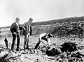
Excavation of dugong remains at Shea's Creek in 1896, during construction of the Alexandra Canal. The curator of the Australian Museum, Robert Etheridge, stands centre wearing a top hat.
Image: Australian Museum archives


