
Aliso Viejo, California facts for kids
Quick facts for kids
Aliso Viejo, California
|
||
|---|---|---|

The Aliso Viejo Town Center
|
||
|
||
| Etymology: Spanish for "Old Sycamore" | ||
| Motto(s):
"Live, Work, Learn, Shop and Play."
|
||

Location of Aliso Viejo within Orange County, California
|
||

Aliso Viejo, California
Location in California

Aliso Viejo, California
Location in the United States

Aliso Viejo, California
Location in North America
|
||
| Country | United States | |
| State | California | |
| County | Orange | |
| Incorporated | July 1, 2001 | |
| Area | ||
| • Total | 6.93 sq mi (17.94 km2) | |
| • Land | 6.93 sq mi (17.94 km2) | |
| • Water | 0.00 sq mi (0.00 km2) 0% | |
| Elevation | 410 ft (125 m) | |
| Population
(2020)
|
||
| • Total | 52,176 | |
| • Density | 7,533.35/sq mi (2,908.80/km2) | |
| Time zone | UTC-8 (PST) | |
| • Summer (DST) | UTC-7 (PDT) | |
| ZIP code |
92656, 92698
|
|
| Area code(s) | 949 | |
| FIPS code | 06-00947 | |
| GNIS feature IDs | 252532, 2409683 | |

Aliso Viejo (Spanish for "Old Sycamore") is a city in the San Joaquin Hills of southern Orange County, California. It had a population of 47,823 as of the 2010 census, up from 40,166 as of the 2000 census. It became Orange County's 34th city on July 1, 2001, the only city in Orange County to be incorporated since 2000. It is bordered by the cities of Laguna Beach on the west and southwest, Laguna Hills on the east, Laguna Niguel on the southeast, and Laguna Woods on the north.
Contents
History
The planned community of Aliso Viejo's original 6,600 acres were once part of the 26,000-acre Moulton Ranch, owned by the Moulton family, who took title in the 1890s to land originally granted to Juan Avila by the Mexican government in 1842. Over the years, portions of the ranch were sold and became Leisure World, Laguna Hills and Laguna Niguel. In 1976, the Mission Viejo Company purchased the remaining 6,600 acres to create a new planned community – Aliso Viejo – with a master plan for 20,000 homes for a planned population of 50,000. The master plan was approved by the Orange County in 1979, and homes were first offered for sale in March 1982. Aliso Viejo's first family moved in that November. As part of the project, 2,600 acres were dedicated to Orange County as part of the Aliso and Wood Canyons Wilderness Park, and 800 additional acres were set aside for local parks, recreation, schools and community facilities. The Aliso Viejo Community Association (AVCA) was set up to manage the local parks and community open space. It was the first community-wide association of its kind in California and has the unique ability to provide a full-range of community services and facilities.
Aliso Viejo was the first planned community in California to plan a balance between the projected resident work force and the number of projected jobs within its borders. Pacific Park, the centrally located 900-acre business park and town center, was expected to ultimately provide more than 22,000 jobs. Every home in Aliso Viejo was located about 1 1/2 miles from Pacific Park, to encourage live-and-work opportunities.
Incorporation
Aliso Viejo had been an unincorporated community since 1979, and incorporated as a city in 2001 due to the efforts of the Aliso Viejo Cityhood 2000 Committee, which was responsible for introducing an initiative on the ballot for the 2001 special election. Voters passed the initiative with 93.3% in favor of incorporation. Carmen Vali-Cave, the co-founder and president of the Committee, became the new city's first mayor.
The seal of the city of Aliso Viejo was adopted in 2001 at incorporation. The seal features several mountains, a boat, a tree, and several buildings. Also, the seal features the slogan "Since 2001", in celebration of the city's incorporation date.
Geography
Aliso Viejo is located at 33°34′30″N 117°43′32″W / 33.57500°N 117.72556°W (33.575096, -117.725431) in the San Joaquin Hills of Orange County. According to the Census Bureau, the city has a total area of 7.5 square miles (19 km2), all of which is land. Aliso Viejo is one of several cities bordering Aliso and Wood Canyons Regional Park. Aliso Creek forms part of the city's boundary with Laguna Niguel to the south, and Wood Canyon Creek forms part of the city's western boundary. Much of the city rests on the east slope of the San Joaquin Hills, which are a coastal mountain range extending for about 15 miles (24 km) along the Pacific coast.
Demographics
| Historical population | |||
|---|---|---|---|
| Census | Pop. | %± | |
| 1990 | 7,612 | — | |
| 2000 | 40,166 | 427.7% | |
| 2010 | 47,823 | 19.1% | |
| 2020 | 52,176 | 9.1% | |
| U.S. Decennial Census | |||
2010
The 2010 United States Census reported that Aliso Viejo had a population of 47,823. The population density was 6,400.4 people per square mile (2,471.2/km2). The racial makeup of Aliso Viejo was 34,437 (89.0%) White (77.8% Non-Hispanic White), 967 (2.0%) African American, 151 (0.1%) Native American, 6,996 (14.6%) Asian, 89 (0.2%) Pacific Islander, 2,446 (5.1%) from other races, and 2,737 (5.7%) from two or more races. Hispanic or Latino of any race were 8,164 persons (17.1%).
The Census reported that 47,354 people (99.0% of the population) lived in households, 450 (0.9%) lived in non-institutionalized group quarters, and 19 (0%) were institutionalized.
There were 18,204 households, out of which 7,095 (39.0%) had children under the age of 18 living in them, 9,358 (51.4%) were opposite-sex married couples living together, 1,966 (10.8%) had a female householder with no husband present, 791 (4.3%) had a male householder with no wife present. There were 987 (5.4%) unmarried opposite-sex partnerships, and 206 (1.1%) same-sex married couples or partnerships. 4,416 households (24.3%) were made up of individuals, and 638 (3.5%) had someone living alone who was 65 years of age or older. The average household size was 2.60. There were 12,115 families (66.6% of all households); the average family size was 3.16.
The population was spread out, with 12,395 people (25.9%) under the age of 18, 3,739 people (7.8%) aged 18 to 24, 17,138 people (35.8%) aged 25 to 44, 12,003 people (25.1%) aged 45 to 64, and 2,548 people (5.3%) who were 65 years of age or older. The median age was 35.1 years. For every 100 females, there were 92.8 males. For every 100 females age 18 and over, there were 89.2 males.
There were 18,867 housing units at an average density of 2,525.1 per square mile (974.9/km2), of which 11,049 (60.7%) were owner-occupied, and 7,155 (39.3%) were occupied by renters. The homeowner vacancy rate was 1.2%; the rental vacancy rate was 3.6%. 29,819 people (62.4% of the population) lived in owner-occupied housing units and 17,535 people (36.7%) lived in rental housing units.
2000
As of the census of 2000, there were 40,166 people, 16,147 households, and 10,689 families residing in what was, at the time, a Census Designated Place (CDP). The population density was 3,927.7 inhabitants per square mile (1,516.0/km2). There were 16,608 housing units at an average density of 1,624.0 per square mile (626.8/km2). The racial makeup of the CDP was 78.16% White, 10.99% Asian, 2.06% Black or African American, 0.39% Native American, 0.22% Pacific Islander, 3.51% from other races, and 4.66% from two or more races. 11.65% of the population were Hispanic or Latino of any race.
There were 16,147 households, out of which 37.7% had children under the age of 18 living with them, 52.7% were married couples living together, 10.2% had a female householder with no husband present, and 33.8% were non-families. 23.8% of all households were made up of individuals, and 1.8% had someone living alone who was 65 years of age or older. The average household size was 2.49 and the average family size was 3.01.
The population was distributed with 26.1% under the age of 18, 5.5% from 18 to 24, 48.8% from 25 to 44, 16.3% from 45 to 64, and 3.4% who were 65 years of age or older. The median age was 33 years. For every 100 females, there were 93.4 males. For every 100 females age 18 and over, there were 91.4 males.
According to a 2007 estimate, the median income for a household in the CDP was $92,280, and the median income for a family was $99,853. Males had a median income of $61,316 versus $44,190 for females. The per capita income for the CDP was $35,244. About 2.3% of families and 2.8% of the population lived below the poverty line, including 3.5% of those under age 18 and 2.8% of those age 65 or over.
Points of interest
- Aliso Viejo Town Center features a movie theater, a wide variety of casual dining restaurants, PetSmart, a Barnes & Noble, a Ralphs supermarket, as well as other shops. It also includes Grand Park which is a center for community concerts and events.
- The Aliso Viejo Library, a branch of the Orange County Public Library system, opened on January 31, 1998.
- Aliso Viejo Golf Course was designed by Nicklaus Design in 1999 and became the Aliso Viejo Country Club with a redesign in 2005.
- Soka University was dedicated on May 3, 2001 with a 103-acre campus and 18 buildings, a $250 million (land and construction) project.
- Soka Performing Arts Center, a 1000-seat concert hall with acoustics designed by Yasuhisa Toyota (who also designed Walt Disney Concert Hall,) opened in September 2011.
- Renaissance ClubSport is a $65 million property which opened in July 2008. It is Marriott's second hotel and fitness resort created in conjunction with Leisure Sports, Inc. (ClubSport) to fulfill the growing demand by local residents and hotel guests for a healthier lifestyle.
Economy
Companies located in Aliso Viejo include:
- 3tera, a cloud computing software vendor
- AND1, a shoe and apparel company
- Buy.com, an online retailer
- Centon Electronics, Inc., a manufacturer of computer memory and flash-based storage devices
- Fluor, an international construction contractor for petrochemical, infrastructure, and environmental projects, headquartered in Aliso Viejo until it was relocated to the Dallas-Fort Worth Metroplex suburb of Irving, Texas in March 2006. Some divisions still reside in Aliso Viejo.
- Ketel One, a vodka company
- Marie Callender's, a restaurant chain
- Microsoft's office after the purchase of DATAllegro
- Nimbus Data, a network storage systems and software company
- Pacific Life, an insurance company
- QLogic, a network storage manufacturer
- Quest Software (formerly Dell Software), a software manufacturer
- Smith Micro Software, a software developer
- Tamiya America, US subsidiary of the manufacturer of model cars Tamiya Corporation, headquartered in Aliso Viejo until it was relocated to Irvine, CA.
- UST Global, an IT, Technology and Digital Transformation company
- USWeb, an Internet marketing company
- Microsemi Corporation, a semiconductor company
- Sony Interactive Entertainment, a multinational video game and digital entertainment company
- Carbine Studios, a video game developer, partnered with NCSOFT
- Metagenics, a medical manufacturing company
- Meta Solar, a solar energy installation company
- Vertos Medical, a manufacturer of surgical instruments used to perform minimally invasive procedures
- Ambry Genetics, a health care genetic lab, a subsidiary of parent company Konica Minolta
Top employers
According to the city's 2016 Comprehensive Annual Financial Report, the top employers in the city are:
| # | Employer | # of employees |
|---|---|---|
| 1 | United Parcel Service | 1,000 |
| 2 | Pacific Life | 811 |
| 3 | Capistrano Unified School District | 679 |
| 4 | Fluor | 630 |
| 5 | Quest Software | 600 |
| 6 | QLogic | 490 |
| 7 | Renaissance Hotels ClubSport Aliso Viejo | 259 |
| 8 | Pepsi Beverages Company | 215 |
| 9 | Smith Micro Software | 200 |
| 10 | Merit Property Management | 199 |
| 11 | Buy.com | 185 |
| 12 | Lennar | 175 |
| 13 | Target Corporation | 170 |
| 14 | Bausch & Lomb | 160 |
| 15 | Ambry Genetics | 777 |
| 16 | The Covington | 153 |
| 17 | LenSx Laser | 150 |
| 18 | Lowe's | 130 |
Sports teams
- The Orange County Gladiators were an American Basketball Association (ABA) expansion team founded in November 2007 until 2009. They played their home games at Aliso Niguel High School.
Education
Public K–12
The city is served by Capistrano Unified School District, which includes these schools:
Elementary
- Canyon Vista Elementary School
- Don Juan Avila Elementary School
- Oak Grove Elementary School
- Wood Canyon Elementary School
Middle school
- Aliso Viejo Middle School
- Don Juan Avila Middle School
High school
- Aliso Niguel High School
Private K–12
- VanDamme Academy
- St. Mary and All Angels School
- Aliso Viejo Christian School
Higher education
- Saddleback College (Mission Viejo, California)
- Irvine Valley College (Irvine, California)
- Orange Coast College (Costa Mesa, California)
- Soka University of America
Notable natives and residents
- Farzad Bonyadi, professional poker player
- Ryan Coiner, Major League Soccer player for the Columbus Crew
- Ryan Getzlaf, center for the Anaheim Ducks
- Jim Gilchrist, politician and founder of the Minuteman Project
- Kenneth Kizer, CEO and former Secretary of Health in the United States Department of Veterans Affairs
- Ivan Koumaev, contestant on the reality series So You Think You Can Dance
- Royce Lewis, baseball player, first selection of 2017 MLB Draft
- Jason Martin, indie rock musician
- Marc Maiffret, computer security expert/computer hacker
- McKayla Maroney, gymnast, 2012 Olympic champion
- Kyla Ross, gymnast, 2012 Olympic champion
- Toni Turner, author
- Alisa Valdez-Rodriguez, author
- Ashley Wagner, figure skater, 3-time U.S. champion
- Alicia Leigh Willis, actress known for her role as Courtney Matthews on General Hospital
Images for kids
-
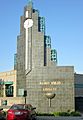
Clock tower of the Aliso Viejo Library
-
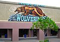
Aliso Niguel High School
-
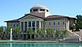
Founders Hall of Soka University of America


See also
 In Spanish: Aliso Viejo para niños
