
Allegheny County, Pennsylvania facts for kids
Quick facts for kids
Allegheny County
|
|||
|---|---|---|---|
.jpg)
|
|||
|
|||

Location within the U.S. state of Pennsylvania
|
|||
 Pennsylvania's location within the U.S. |
|||
| Country | |||
| State | |||
| Founded | September 24, 1788 | ||
| Named for | Allegheny River | ||
| Seat | Pittsburgh | ||
| Largest city | Pittsburgh | ||
| Area | |||
| • Total | 745 sq mi (1,930 km2) | ||
| • Land | 730 sq mi (1,900 km2) | ||
| • Water | 14 sq mi (40 km2) 1.9%% | ||
| Population
(2020)
|
|||
| • Total | 1,250,578 | ||
| • Density | 1,713/sq mi (661/km2) | ||
| Time zone | UTC−5 (Eastern) | ||
| • Summer (DST) | UTC−4 (EDT) | ||
| Congressional districts | 17th, 18th | ||
|
Pennsylvania Historical Marker
|
|||
| Designated: | December 30, 1982 | ||


Allegheny County is located in the southwest of the U.S. state of Pennsylvania. As of the 2020 census, the population was 1,250,578, making it the state's second-most populous county, following Philadelphia County. The county seat is Pittsburgh. Allegheny County is included in the Pittsburgh, PA Metropolitan Statistical Area, and in the Pittsburgh Designated Market Area.
Allegheny was the first county in Pennsylvania to be given a Native American name. It was named after the Lenape word for the Allegheny River. The meaning of "Allegheny" is uncertain. It is usually said to mean "fine river". Stewart says that the name may come from a Lenape account of an ancient mythical tribe called "Allegewi", who lived along the river before being taken over by the Lenape.
Contents
History
Not a great deal is known about the native inhabitants of the region prior to European contact. During the colonial era various native groups claimed or settled in the area, resulting in a multi-ethnic mix that included Iroquois, Lenape, Shawnee, and Mingo. European fur traders such as Peter Chartier established trading posts in the region in the early eighteenth century.
In 1749 Captain Pierre Joseph Céloron de Blainville, claimed the Ohio Valley and all of western Pennsylvania for Louis XV of France. The captain traveled along the Ohio and Allegheny rivers inserting lead plates in the ground to mark the land for France.
Since most of the towns during that era were developed along waterways, both the French and the British desired control over the local rivers. Therefore, the British sent Major George Washington to try to compel the French to leave their posts, with no success. Having failed in his mission, he returned and nearly drowned crossing the ice-filled Allegheny River. In 1754, the English tried again to enter the area. This time, they sent 41 Virginians to build Fort Prince George. The French got news of the plan and sent an army to take over the fort, which they then resumed building with increased fortification, renaming it Fort Duquesne.
The loss of the fort cost the English dearly because Fort Duquesne became one of the focal points of the French and Indian War. The first attempt to retake the fort, the Braddock Expedition, failed miserably. It was not until General John Forbes attacked in 1758, four years after they had lost the original fort, that they recaptured and destroyed it. They subsequently built a new fort on the site, including a moat, and named it Fort Pitt. The site is now Pittsburgh's Point State Park.
Both Pennsylvania and Virginia claimed the region that is now Allegheny County. Pennsylvania administered most of the region as part of its Westmoreland County. Virginia considered everything south of the Ohio River and east of the Allegheny River to be part of its Yohogania County and governed it from Fort Dunmore. In addition, parts of the county were located in the proposed British colony of Vandalia and the proposed U.S. state of Westsylvania. The overlapping boundaries, multiple governments, and confused deed claims soon proved unworkable. In 1780 Pennsylvania and Virginia agreed to extend the Mason–Dixon line westward, and the region became part of Pennsylvania. From 1781 until 1788, much of what had been claimed as part of Yohogania County, Virginia, was administered as a part of the newly created Washington County, Pennsylvania.
Allegheny County was officially created on September 24, 1788, from parts of Washington and Westmoreland counties. It was formed due to pressure from settlers living in the area around Pittsburgh, which became the county seat in 1791. The county originally extended all the way north to the shores of Lake Erie and became the "mother county" for most of what is now northwestern Pennsylvania. By 1800, the county's current borders were set.

In the 1790s, a whiskey excise tax was imposed by the United States federal government. This started the so-called Whiskey Rebellion when the farmers who depended on whiskey income refused to pay and drove off tax collector John Neville. After a series of demonstrations by farmers, President George Washington sent troops to stop the rebellion.
The area developed rapidly throughout the 19th century to become the center of steel production in the nation. Pittsburgh would later be labeled the "Steel Capital of the World".
Geography
According to the U.S. Census Bureau, the county has a total area of 745 square miles (1,930 km2), of which 730 square miles (1,900 km2) is land and 14 square miles (36 km2) (1.9%) is water.
Allegheny County is known for the three major rivers that flow through it: the Allegheny River and the Monongahela River converge at Downtown Pittsburgh to form the Ohio River. The Youghiogheny River flows into the Monongahela River at McKeesport, 10 miles (16 km) southeast. Several islands are located within the riverine systems. Water from these rivers eventually flows into the Gulf of Mexico via the Mississippi River. Although the county's industrial growth caused the clearcutting of forests, a significant woodland remains.
Adjacent counties
- Butler County (north)
- Armstrong County (tangent to the northeast)
- Westmoreland County (east)
- Washington County (southwest)
- Beaver County (northwest)
Major Highways

 I-76 / Penna Turnpike
 I-79
I-79 I-279
I-279 I-376
I-376 I‑376 Bus.
 I-579
I-579 US 19
US 19
US 19 Truck
US 19 Byp. US 22
US 22
US 22 Bus. US 30
US 30
US 30 Truck PA 8
PA 8 PA 28
PA 28 PA 51
PA 51 PA 65
PA 65 PA 130
 PA 380
 Toll PA 576
 PA 837
Demographics
| Historical population | |||
|---|---|---|---|
| Census | Pop. | %± | |
| 1790 | 10,203 | — | |
| 1800 | 15,087 | 47.9% | |
| 1810 | 25,317 | 67.8% | |
| 1820 | 34,921 | 37.9% | |
| 1830 | 50,552 | 44.8% | |
| 1840 | 81,235 | 60.7% | |
| 1850 | 138,290 | 70.2% | |
| 1860 | 178,831 | 29.3% | |
| 1870 | 262,204 | 46.6% | |
| 1880 | 355,869 | 35.7% | |
| 1890 | 551,959 | 55.1% | |
| 1900 | 775,058 | 40.4% | |
| 1910 | 1,018,463 | 31.4% | |
| 1920 | 1,185,808 | 16.4% | |
| 1930 | 1,374,410 | 15.9% | |
| 1940 | 1,411,539 | 2.7% | |
| 1950 | 1,515,237 | 7.3% | |
| 1960 | 1,628,587 | 7.5% | |
| 1970 | 1,605,016 | −1.4% | |
| 1980 | 1,450,085 | −9.7% | |
| 1990 | 1,336,449 | −7.8% | |
| 2000 | 1,281,666 | −4.1% | |
| 2010 | 1,223,348 | −4.6% | |
| 2020 | 1,250,578 | 2.2% | |
| U.S. Decennial Census 1790–1960 1900–1990 1990–2000 2010–2018 |
|||
As of the 2010 census, there were 1,223,348 people living in the county. The population density was 1676 people per square mile (647/km2). The racial makeup of the county was 82.87% White, 14.39% Black or African American, 2.94% Asian, 0.03% Pacific Islander, 0.37% from other races, and 1.40% from two or more races. About 1.31% of the population were Hispanic or Latino of any race.
At the census of 2000, there were 1,281,666 people, 537,150 households, and 332,495 families living in the county. The population density was 1,755 people per square mile (678/km2). There were 583,646 housing units at an average density of 799 per square mile (309/km2). The racial makeup of the county was 84.33% White, 12.41% Black or African American, 0.12% Native American, 1.69% Asian, 0.03% Pacific Islander, 0.34% from other races, and 1.07% from two or more races. About 0.87% of the population were Hispanic or Latino of any race. 20.0% were of German, 15.0% Italian, 12.7% Irish, 7.5% Polish and 5.1% English ancestry according to Census 2000. 93.5% spoke English and 1.3% Spanish as their first language.
There were 537,150 households, out of which 26.40% had children under the age of 18 living with them, 46.10% were married couples living together, 12.40% had a female householder with no husband present, and 38.10% were non-families. Some 32.70% of all households were made up of individuals, and 13.20% had someone living alone who was 65 years of age or older. The average household size was 2.31 and the average family size was 2.96.
The age distribution of the population shows 21.90% under the age of 18, 8.50% from 18 to 24, 28.30% from 25 to 44, 23.40% from 45 to 64, and 17.80% who were 65 years of age or older. The median age was 40. For every 100 females, there were 90.00 males; for every 100 females age 18 and over, there were 86.20 males.
Regions
- East Hills
- North Hills
- South Hills
- West Hills
- City of Pittsburgh
Transportation
Allegheny County's public transportation provider is the Port Authority of Allegheny County. The Allegheny County Department of Public Works oversees infrastructure, maintenance, and engineering services in the county.
The Three Rivers Heritage Trail provides uninterrupted bicycle and pedestrian connections along the three rivers in the city, and the Great Allegheny Passage trail runs from downtown Pittsburgh to Washington, D.C.
The Allegheny County Airport is the original airport for Pittsburgh and houses a number of flight schools, charter flight operations, and medevac operations.
Major roadways
 Interstate 79 runs north to south from Warrendale to Bridgeville
 Interstate 279 runs north to south from Franklin Park to Downtown
 Interstate 579 (Crosstown Boulevard), from Interstate 279 on the north shore to Liberty Bridge / Boulevard of the Allies
 Interstate 76 / PA Turnpike runs east to west from Interstate 376 in Monroeville to the Warrendale interchange (at Interstate 79)
 Interstate 376 runs east to west from Interstate 76 in Monroeville across the county to Pittsburgh International Airport and beyond
 Pennsylvania Turnpike 576 (future I-576) runs south from Interstate 376 at the Pittsburgh International Airport to US Route 22, also called the Findlay Connector. The next phase of this road extension, from US Route 22 to Interstate 79 running along the County line, is currently under construction and is expected to be open to traffic in 2020.
- US Route 19 runs north to south from Warrendale to Upper St. Clair
- US Route 22 runs west to east, along much of US Route 30 and Interstate 376, from Imperial to Monroeville
- US Route 30 runs west to east from Clinton to North Versailles, joining US 22 and Interstate 376 south of the Pittsburgh International Airport and leaving those same two routes in Wilkinsburg
For information about major state roads, see list of State Routes in Allegheny County, Pennsylvania and Allegheny County Belt System.
Parks and recreation
There are two Pennsylvania state parks in Allegheny County. Point State Park is at the confluence of the Allegheny and Monongahela rivers in Downtown Pittsburgh, and Allegheny Islands State Park is in the Allegheny River in Harmar Township and is undeveloped as of August 2010.
Communities

Under Pennsylvania law, there are four types of incorporated municipalities: cities, boroughs, townships, and (in one case) a town. The following municipalities are in Allegheny County:
Cities
- Clairton
- Duquesne
- McKeesport
- Pittsburgh (county seat)
Boroughs
- Aspinwall
- Avalon
- Baldwin
- Bell Acres
- Bellevue
- Ben Avon
- Ben Avon Heights
- Bethel Park
- Blawnox
- Brackenridge
- Braddock
- Braddock Hills
- Bradford Woods
- Brentwood
- Bridgeville
- Carnegie
- Castle Shannon
- Chalfant
- Cheswick
- Churchill
- Coraopolis
- Crafton
- Dormont
- Dravosburg
- East McKeesport
- East Pittsburgh
- Edgewood
- Edgeworth
- Elizabeth
- Emsworth
- Etna
- Forest Hills
- Fox Chapel
- Franklin Park
- Glassport
- Glen Osborne
- Glenfield
- Green Tree
- Haysville
- Heidelberg
- Homestead
- Ingram
- Jefferson Hills
- Leetsdale
- Liberty
- Lincoln
- McDonald (mostly in Washington County)
- McKees Rocks
- Millvale
- Monroeville
- Mount Oliver
- Munhall
- North Braddock
- Oakdale
- Oakmont
- Pennsbury Village
- Pitcairn
- Pleasant Hills
- Plum
- Port Vue
- Rankin
- Rosslyn Farms
- Sewickley
- Sewickley Heights
- Sewickley Hills
- Sharpsburg
- Springdale
- Swissvale
- Tarentum
- Thornburg
- Trafford (mostly in Westmoreland County)
- Turtle Creek
- Verona
- Versailles
- Wall
- West Elizabeth
- West Homestead
- West Mifflin
- West View
- Whitaker
- White Oak
- Whitehall
- Wilkinsburg
- Wilmerding
Townships
- Aleppo
- Baldwin
- Collier
- Crescent
- East Deer
- Elizabeth
- Fawn
- Findlay
- Forward
- Frazer
- Hampton
- Harmar
- Harrison
- Indiana
- Kennedy
- Kilbuck
- Leet
- Marshall
- McCandless
- Moon
- Mount Lebanon
- Neville
- North Fayette
- North Versailles
- O'Hara
- Ohio
- Penn Hills
- Pine
- Reserve
- Richland
- Robinson
- Ross
- Scott
- Shaler
- South Fayette
- South Park
- South Versailles
- Springdale
- Stowe
- Upper Saint Clair
- West Deer
- Wilkins
Census-designated places
Census-designated places are geographical areas designated by the US Census Bureau for the purposes of compiling demographic data. They are not actual jurisdictions under Pennsylvania law. Other unincorporated communities, such as villages, may be listed here as well.
Unincorporated communities
- Acmetonia
- Blackridge
- Blanchard
- Broughton
- Bruceton
- Creighton
- Cubbage Hill
- Cuddy
- Dorseyville
- Ewingsville
- Harmarville
- Hickory Heights
- Ingomar
- Karns
- Keown Station
- Kirwan Heights
- Library
- Mount Vernon
- Natrona
- Natrona Heights
- Nevillewood
- Presto
- Regent Square
- Sheraden
- Treveskyn
- Wexford
- Wildwood
Former places
Many political subdivisions of Allegheny County have come and gone through subdivision or annexation through the years. These include:
- Allegheny City – the area that is now the North Shore (or North Side) of the City of Pittsburgh, north of the Allegheny River.
- Allentown Borough – now the neighborhood of Allentown in Pittsburgh.
- Birmingham Borough – what is now Pittsburgh's South Side.
- Brushton Borough
- Carrick Borough – now the neighborhood of Carrick. Formed out of Baldwin Township in 1904, this borough existed until it was annexed by Pittsburgh in 1927. It was named for Carrick-on-Suir, Ireland. To this day, some of the manhole covers bear the Carrick Borough name.
- Collins Township – in what is now the northeast part of the City of Pittsburgh, east of Lawrenceville and north of Penn Avenue.
- Knoxville Borough
- Lawrenceville Borough
- McClure Township – McClure was formed in 1858 from the section of Ross Township adjacent to Allegheny City. In 1867 McClure, along with sections of Reserve Township, was incorporated into Allegheny City. The McClure section of this annexation became Wards 9 (Woods Run Area) and 11 (present day Brighton Heights) in the City of Pittsburgh.
- Mifflin Township- comprised the modern day communities of Whitaker, West Mifflin, West Homestead, West Elizabeth, Pleasant Hills, Munhall, Lincoln Place, Jefferson Hills, Homestead, Hays, Duquesne, Dravosburg, Clairton and part of Baldwin.
- Patton Township – was in east central part of the county, north of North Versailles Township, east of Wilkins and Penn Townships, and south of Plum Township. In U.S. census for 1860–1880. In 1951 it became incorporated as the borough of Monroeville.
- Northern Liberties Borough – in what is now the Strip District of Pittsburgh. The borough was annexed to Pittsburgh in 1837 as the first addition to the city's original territory.
- Peebles Township – included most of what is now the eastern part of the city of Pittsburgh from the Monongahela River in the south (today's Hazelwood) to the Allegheny River in the north. It was subdivided into Collins and Liberty townships, all of which were incorporated into Pittsburgh in 1868.
- Pitt Township
- St. Clair Township – stretched from the Monongahela River south to the Washington County line. It divided into Lower St. Clair, which eventually became part of the City of Pittsburgh, Dormont, Mount Lebanon, and Upper St. Clair.
- Snowden – now known as South Park Township.
- Sterrett Township
- Temperanceville – what is now Pittsburgh's West End.
- Union Borough – the area surrounding Temperanceville.
- West Liberty Borough – now the neighborhoods of Brookline and Beechview in Pittsburgh.
Population ranking
The population ranking of the following table is based on the 2010 census of Allegheny County.
† county seat
| Rank | City/Town/etc. | Population (2010 Census) | Municipal type | Incorporated |
|---|---|---|---|---|
| 1 | † Pittsburgh | 305,704 | City | 1794 (borough) 1816 (city) |
| 2 | Penn Hills | 42,329 | Municipality | 1851 (Penn Twp.) 1958 (Penn Hills Twp.) 1976 (municipality) |
| 3 | Mt. Lebanon | 33,137 | Municipality | 1912 (township) 1975 (municipality) |
| 4 | Bethel Park | 32,313 | Municipality | 1949 (borough) 1978 (municipality) |
| 5 | Monroeville | 28,386 | Municipality | 1951 |
| 6 | Plum | 27,126 | Borough | 1788 (township) 1956 (borough) |
| 7 | Allison Park | 21,552 | CDP | |
| 8 | West Mifflin | 20,313 | Borough | 1942 |
| 9 | Baldwin | 19,767 | Borough | 1950 |
| 10 | McKeesport | 19,731 | City | 1842 (borough) 1891 (city) |
| 11 | Wilkinsburg | 15,930 | Borough | 1871 (Sterrett Twp.) 1887 (borough) |
| 12 | Whitehall | 13,944 | Borough | 1948 |
| 13 | Franklin Park | 13,470 | Borough | |
| 14 | Munhall | 11,406 | Borough | |
| 15 | Carnot-Moon | 11,372 | CDP | |
| 16 | Jefferson Hills | 10,619 | Borough | |
| 17 | Brentwood | 9,643 | Borough | 1916 |
| 18 | Swissvale | 8,983 | Borough | |
| 19 | Glenshaw | 8,981 | CDP | |
| 20 | Dormont | 8,593 | Borough | 1909 |
| 21 | Bellevue | 8,370 | Borough | 1867 |
| 22 | Castle Shannon | 8,316 | Borough | 1919 |
| 23 | Pleasant Hills | 8,268 | Borough | |
| 24 | Carnegie | 7,972 | Borough | 1894 |
| 25 | White Oak | 7,862 | Borough | |
| 26 | Clairton | 6,796 | City | 1903 (borough) 1922 (city) |
| 27 | West View | 6,771 | Borough | |
| 28 | Forest Hills | 6,518 | Borough | 1919 |
| 29 | Oakmont | 6,303 | Borough | 1889 |
| 30 | McKees Rocks | 6,104 | Borough | 1892 |
| 31 | Crafton | 5,951 | Borough | |
| 32 | Coraopolis | 5,677 | Borough | 1886 |
| 33 | Duquesne | 5,565 | City | 1891 (borough) 1918 (city) |
| 34 | Fox Chapel | 5,388 | Borough | |
| 35 | Turtle Creek | 5,349 | Borough | |
| 36 | Bridgeville | 5,148 | Borough | 1901 |
| 37 | North Braddock | 4,857 | Borough | |
| 38 | Avalon | 4,705 | Borough | 1874 |
| 39 | Tarentum | 4,530 | Borough | 1842 |
| 40 | Glassport | 4,483 | Borough | |
| 41 | Green Tree | 4,432 | Borough | 1885 |
| 42 | Sewickley | 3,827 | Borough | |
| 43 | Port Vue | 3,798 | Borough | |
| 44 | Millvale | 3,744 | Borough | |
| 45 | Pitcairn | 3,689 | Borough | |
| 46 | Etna | 3,451 | Borough | |
| 47 | Sharpsburg | 3,446 | Borough | |
| 48 | Springdale | 3,405 | Borough | |
| 49 | Mount Oliver | 3,403 | Borough | |
| 50 | Ingram | 3,330 | Borough | |
| 51 | Brackenridge | 3,260 | Borough | 1901 |
| 52 | Trafford (mostly in Westmoreland County) | 3,174 | Borough | 1904 |
| 53 | Homestead | 3,165 | Borough | |
| 54 | Edgewood | 3,118 | Borough | 1888 |
| 55 | Churchill | 3,011 | Borough | |
| 56 | Aspinwall | 2,801 | Borough | 1892 |
| 57 | Gibsonia | 2,733 | CDP | |
| 58 | Liberty | 2,551 | Borough | |
| 59 | Imperial | 2,541 | CDP | |
| 60 | Verona | 2,474 | Borough | 1871 |
| 61 | Emsworth | 2,449 | Borough | |
| 62 | Greenock | 2,195 | CDP | |
| 63 | Wilmerding | 2,190 | Borough | |
| 64 | Braddock | 2,159 | Borough | 1867 |
| 65 | McDonald (mostly in Washington County) | 2,149 | Borough | 1889 |
| 66 | East McKeesport | 2,126 | Borough | |
| 67 | Rankin | 2,122 | Borough | |
| 68 | West Homestead | 1,929 | Borough | |
| 69 | Braddock Hills | 1,880 | Borough | 1946 |
| 70 | East Pittsburgh | 1,822 | Borough | |
| 71 | Dravosburg | 1,792 | Borough | |
| 72 | Ben Avon | 1,781 | Borough | 1891 |
| 73 | Bakerstown | 1,761 | CDP | |
| 74 | Cheswick | 1,746 | Borough | |
| 75 | Sturgeon | 1,710 | CDP | |
| 76 | Edgeworth | 1,680 | Borough | |
| 77 | Versailles | 1,515 | Borough | |
| 78 | Elizabeth | 1,493 | Borough | |
| 79 | Oakdale | 1,459 | Borough | |
| 80 | Russellton | 1,440 | CDP | |
| 81 | Blawnox | 1,432 | Borough | 1925 |
| 82 | Bell Acres | 1,388 | Borough | 1960 |
| 83 | Whitaker | 1,271 | Borough | |
| 84 | Heidelberg | 1,244 | Borough | |
| 85 | Leetsdale | 1,218 | Borough | |
| 86 | Bradford Woods | 1,171 | Borough | 1915 |
| 87 | Rennerdale | 1,150 | CDP | |
| 88 | Lincoln | 1,072 | Borough | |
| 89 | Curtisville | 1,064 | CDP | |
| 90 | Enlow | 1,013 | CDP | |
| 91 | Harwick | 899 | CDP | |
| 92 | Sewickley Heights | 810 | Borough | |
| 93 | Chalfant | 800 | Borough | |
| 94 | Bairdford | 698 | CDP | |
| 95 | Pennsbury Village | 661 | Borough | |
| 96 | Sewickley Hills | 639 | Borough | |
| 97 | Wall | 580 | Borough | |
| 98 | Noblestown | 575 | CDP | |
| 99 | Glen Osborne | 547 | Borough | |
| 100 | Boston | 545 | CDP | |
| 101 | West Elizabeth | 518 | Borough | |
| 102 | Thornburg | 455 | Borough | |
| 103 | Clinton | 434 | CDP | |
| 104 | Rosslyn Farms | 427 | Borough | |
| 105 | Ben Avon Heights | 371 | Borough | 1913 |
| 106 | Glenfield | 205 | Borough | |
| 107 | Haysville | 70 | Borough |
Economy
In the late 18th century farming played a critical role in the growth of the area. There was a surplus of grain due to transportation difficulties in linking with the eastern portion of the state. As a result, the farmers distilled the grain into whiskey, which significantly helped the farmers financially.
.svg)
The area quickly became a key manufacturing area in the young nation. Coupled with deposits of iron and coal, and the easy access to waterways for barge traffic, the city quickly became one of the most important steel producing areas in the world. Based on 2007 data from the US Army Corps of Engineers, Pittsburgh is the second (after Laredo, Texas) busiest inland port in the nation.
US steel production declined late in the 20th century, and Allegheny County's economy began a shift to other industries. It is presently known for its hospitals, universities, and industrial centers. Despite the decline of heavy industry, Pittsburgh is home to a number of major companies and is ranked in the top ten among US cities hosting headquarters of Fortune 500 corporations, including U.S. Steel Corporation, PNC Financial Services Group, PPG Industries, and H. J. Heinz Company.
The county leads the state in number of defense contractors supplying the U.S. military.
Sports
- Pittsburgh Steelers, football team
- Pittsburgh Penguins, ice hockey team
- Pittsburgh Pirates, baseball team
- Pittsburgh Riverhounds, soccer team
- Pittsburgh Passion, Women's Football Alliance team
- Pittsburgh Thunderbirds, American Ultimate Disc League team
- Steel City Roller Derby, Women's Flat Track Derby Association team
Education
Colleges and universities
- Byzantine Catholic Seminary of SS. Cyril and Methodius
- Carlow University
- Carnegie Mellon University
- Chatham University
- DeVry University
- Duquesne University
- La Roche College
- Penn State Greater Allegheny
- Pittsburgh Theological Seminary
- Point Park University
- Reformed Presbyterian Theological Seminary
- Robert Morris University
- University of Pittsburgh
Community, junior and technical colleges
- Bidwell Training Center
- Community College of Allegheny County
- Empire Beauty Schools
- Fountain of Youth Academy of Cosmetology
- Institute of Medical and Business Careers
- North Hills Beauty Academy
- Pittsburgh Career Institute
- Pittsburgh Institute of Aeronautics
- Pittsburgh Institute of Mortuary Science
- Pittsburgh Multicultural Cosmetology Academy
- Pittsburgh Technical College
- Rosedale Technical College
- South Hills Beauty Academy
- Triangle Tech
- Vet Tech Institute
Public school districts

|
|
|
Approved private schools
These private schools provide special education for disabled students:
- ACLD Tillotson School, Pittsburgh
- The Day School at The Children's Institute, Pittsburgh
- DePaul School for Hearing and Speech, Pittsburgh
- Easter Seal Society of Western Pennsylvania
- The Education Center at the Watson Institute, Sewickley
- Pace School, Pittsburgh
- Pressley Ridge Day School, Pittsburgh
- Pressley Ridge School for the Deaf, Pittsburgh
- The Watson Institute Friendship Academy, Pittsburgh
- Wesley Spectrum Highland Services, Pittsburgh
- Western Pennsylvania School for Blind Children, Pittsburgh
- Western Pennsylvania School for the Deaf, Pittsburgh
Private high schools
- Bishop Canevin High School
- Central Catholic High School
- Cornerstone Christian Preparatory Academy
- Eden Christian Academy
- The Ellis School
- Hillcrest Christian Academy
- Harvest Baptist Academy
- Imani Christian Academy
- Oakland Catholic High School
- Our Lady of the Sacred Heart High School
- Serra Catholic High School
- Seton-La Salle Catholic High School
- Sewickley Academy
- Shady Side Academy
- St. Joseph High School
- Vincentian Academy
- Winchester Thurston School
Images for kids
-
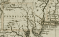
1680 British map of western Pennsylvania and Allegheny County from the Darlington Collection

See also
 In Spanish: Condado de Allegheny para niños
