Altenburger Land Rural District facts for kids
Quick facts for kids
Altenburger Land
|
|
|---|---|
 |
|
| Country | |
| State | Thuringia |
| Capital | Altenburg |
| Area | |
| • Total | 569 km2 (220 sq mi) |
| Population
(2001)
|
|
| • Total | 113,500 |
| • Density | 199.47/km2 (516.6/sq mi) |
| Time zone | UTC+1 (CET) |
| • Summer (DST) | UTC+2 (CEST) |
| Vehicle registration | ABG |
| Website | altenburgerland.de |
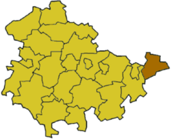
Altenburger Land is a rural district in Thuringia, Germany.
History
The city of Altenburg and the surrounding land were the tiny duchy of Saxe-Altenburg from 1826 to 1918; afterwards it was a state within the Weimar Republic for a short time, before it was dissolved in 1922 in order to join the state of Thuringia.
The district in its present borders was started in 1922 as "Altenburg". In 1952 districts was split in two, called Altenburg and Schmölln. They were joined up again in 1994, but called "Altenburger Land".
Altenburger Land is the easternmost district of Thuringia. It is a mainly agricultural region.
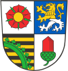
Coat of arms
 |
The coat of arms displays:
|
Towns and municipalities
| Verwaltungsgemeinschaft-free towns | and municipalities |
|---|---|
|
|
| Verwaltungsgemeinschaften | ||
|---|---|---|
|
|
|
| 1seat of the Verwaltungsgemeinschaft | ||
Related websites

All content from Kiddle encyclopedia articles (including the article images and facts) can be freely used under Attribution-ShareAlike license, unless stated otherwise. Cite this article:
Altenburger Land Rural District Facts for Kids. Kiddle Encyclopedia.
