
Amador City, California facts for kids
Quick facts for kids
Amador City
|
|
|---|---|

Historic buildings in Amador City
|
|
| Nickname(s):
The gold country’s hidden nugget
|
|
| Motto(s):
"Essence of the California Gold & Wine Country"
|
|

Location of Amador City in Amador County, California.
|
|

Amador City
Location in California

Amador City
Location in the United States
|
|
| Country | |
| State | |
| County | Amador |
| Settled | 1853 |
| Incorporated | June 2, 1915 |
| Area | |
| • Total | 0.31 sq mi (0.80 km2) |
| • Land | 0.31 sq mi (0.80 km2) |
| • Water | 0.00 sq mi (0.00 km2) 0% |
| Elevation | 919 ft (280 m) |
| Population
(2020)
|
|
| • Total | 200 |
| • Density | 645.16/sq mi (249.46/km2) |
| Time zone | UTC-8 (PST) |
| • Summer (DST) | UTC-7 (PDT) |
| ZIP code |
95601
|
| Area code(s) | 209 |
| FIPS code | 06-01514 |
| GNIS feature IDs | 1657922, 2409693 |
Amador City (formerly, Amadore's Creek and South Amador) is a city in Amador County, California, United States. The population was 185 at the 2010 census, down from 196 at the 2000 census, making it the least populous city in California. Amador City is also noted for being the smallest city in California by area.
Contents
Geography
Amador City is located at 38°25′10″N 120°49′27″W / 38.41944°N 120.82417°W.
Only two miles from Sutter Creek on Highway 49, Amador City is the state’s smallest incorporated city by area. According to the United States Census Bureau, the city has a total area of 0.3 square miles (0.78 km2), all of which is land.
History
The city was founded in 1863 and was incorporated into a city around 1915. It was named after Amador County, California, which in turn was named after California soldier and wealthy rancher Jose Maria Amador, who, in 1848-1849, was prospecting an unknown creek in this historically rich gold bearing area called the Motherlode of California. There were no known settlements until 1851. The California Gold Rush changed the landscape of California. Amador's most famous and productive mine, the Keystone, produced about $24 million in gold during 1853-1942. These prices would be higher using today's gold standard.
A post office was established at Amador City in 1863.
Demographics
| Historical population | |||
|---|---|---|---|
| Census | Pop. | %± | |
| 1880 | 824 | — | |
| 1890 | 984 | 19.4% | |
| 1920 | 377 | — | |
| 1930 | 171 | −54.6% | |
| 1940 | 249 | 45.6% | |
| 1950 | 151 | −39.4% | |
| 1960 | 202 | 33.8% | |
| 1970 | 156 | −22.8% | |
| 1980 | 136 | −12.8% | |
| 1990 | 196 | 44.1% | |
| 2000 | 196 | 0.0% | |
| 2010 | 185 | −5.6% | |
| 2020 | 200 | 8.1% | |
| U.S. Decennial Census | |||
2010
At the 2010 census Amador City had a population of 185. The population density was 589.6 people per square mile (227.7/km2). The racial makeup of Amador City was 171 (92.4%) White, 0 (0.0%) African American, 4 (2.2%) Native American, 2 (1.1%) Asian, 0 (0.0%) Pacific Islander, 2 (1.1%) from other races, and 6 (3.2%) from two or more races. Hispanic or Latino of any race were 11 people (5.9%).
The whole population lived in households, no one lived in non-institutionalized group quarters and no one was institutionalized.
There were 85 households, 22 (25.9%) had children under the age of 18 living in them, 35 (41.2%) were opposite-sex married couples living together, 9 (10.6%) had a female householder with no husband present, 3 (3.5%) had a male householder with no wife present. There were 10 (11.8%) unmarried opposite-sex partnerships, and 0 (0%) same-sex married couples or partnerships. 26 households (30.6%) were one person and 9 (10.6%) had someone living alone who was 65 or older. The average household size was 2.18. There were 47 families (55.3% of households); the average family size was 2.74.
The age distribution was 37 people (20.0%) under the age of 18, 18 people (9.7%) aged 18 to 24, 40 people (21.6%) aged 25 to 44, 65 people (35.1%) aged 45 to 64, and 25 people (13.5%) who were 65 or older. The median age was 43.5 years. For every 100 females, there were 94.7 males. For every 100 females age 18 and over, there were 100.0 males.
There were 108 housing units at an average density of 344.2 per square mile (132.9/km2), of which 85 were occupied, 54 (63.5%) by the owners and 31 (36.5%) by renters. The homeowner vacancy rate was 6.9%; the rental vacancy rate was 8.8%. 111 people (60.0% of the population) lived in owner-occupied housing units and 74 people (40.0%) lived in rental housing units.
2000
At the 2000 census there were 196 people in 85 households, including 54 families, in the city. The population density was 601.7 people per square mile (229.3/km2). There were 91 housing units at an average density of 279.4 per square mile (106.5/km2). The racial makeup of the city was 90.82% White, 1.02% Native American, 4.08% from other races, and 4.08% from two or more races. Hispanic or Latino of any race were 9.18%.
There were 85 households, 23.5% had children under the age of 18 living with them, 43.5% were married couples living together, 15.3% had a female householder with no husband present, and 35.3% were non-families. 27.1% of households were made up of individuals, and 10.6% had someone living alone who was 65 or older. The average household size was 2.31 and the average family size was 2.76.
The age distribution was 19.4% under the age of 18, 7.7% from 18 to 24, 27.0% from 25 to 44, 32.7% from 45 to 64, and 13.3% 65 or older. The median age was 42 years. For every 100 females, there were 92.2 males. For every 100 females age 18 and over, there were 100.0 males.
The median household income was $45,625 and the median family income was $39,861. Males had a median income of $30,313 versus $16,250 for females. The per capita income for the city was $17,963. About 14.0% of families and 22.9% of the population were below the poverty line, including 42.5% of those under the age of 18 and none of those 65 and older.
Points of interest

Traveling the two blocks on Highway 49 the traveler can see signs of abandonment in this once thriving city, a contrast to the time when the placers and underground mines produced in abundance. An abandoned brick building stands next to the Fleehart Store, a beautiful reflection of the stone masonry of the time. Also on Main Street is the old Imperial Hotel, another example of the beautiful brickwork of California's past. A bridge replacement project completed in 2014 has beautified and revitalized the center of the city, providing patio dining at the Imperial Hotel, new public restrooms and improved access to the many quaint shops, wine tasting rooms and purveyors of unique, tasty comestibles.
- Little Amador Railroad — Remnants remain of an incredibly-detailed G-Scale model train set in a garden that featured miniature mines and mills and turn-of-the-century full-size mining equipment.
- Amador City Cemetery — located behind the Imperial Hotel. Visitors can take a self-guided tour of the 1.25-acre (5,100 m2) cemetery that dates back to the beginning of the town. Historic Highway 49
Education
There are currently no schools within Amador City's boundaries. However, the city is serviced by Amador High School, Ione Junior High and Sutter Creek Elementary.
Images for kids
-
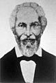
Amador City is named after José María Amador, a Californio miner who found gold in the area in 1848.
-
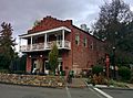
The Imperial Hotel with the new patio.
.jpg)

See also
 In Spanish: Amador City para niños
