Anadarko, Oklahoma facts for kids
Quick facts for kids
Anadarko, Oklahoma
|
|
|---|---|
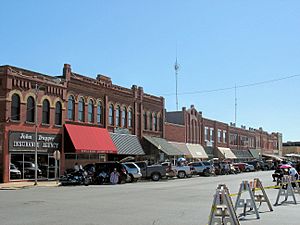
Downtown Anadarko, Oklahoma
|
|
| Motto(s):
"Indian Capital of the Nation"
|
|
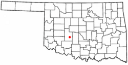
Location of Anadarko, Oklahoma
|
|
| Country | United States |
| State | Oklahoma |
| County | Caddo |
| Area | |
| • Total | 7.26 sq mi (18.82 km2) |
| • Land | 7.19 sq mi (18.63 km2) |
| • Water | 0.07 sq mi (0.19 km2) |
| Elevation | 1,180 ft (360 m) |
| Population
(2020)
|
|
| • Total | 5,745 |
| • Density | 791.3/sq mi (305.26/km2) |
| Time zone | UTC-6 (Central (CST)) |
| • Summer (DST) | UTC-5 (CDT) |
| ZIP code |
73005
|
| Area code(s) | 405 |
| FIPS code | 40-02050 |
| GNIS feature ID | 1089618 |
| Website | City Website |
Anadarko is a city in Caddo County, Oklahoma, United States. The city is fifty miles southwest of Oklahoma City. The population was 5,745 at the 2020 census. It is the county seat of Caddo County.
Contents
History
Anadarko got its name when its post office was established in 1873. The designation came from the Nadarko Indians, a branch of the Caddo, and the "A" was added by clerical error.
In 1871, the Wichita Agency was reestablished on the north bank of the Washita River after being destroyed in the American Civil War. The Wichita Agency administered the affairs of the Wichita, Caddo and other tribes. In 1878, the Kiowa-Comanche Agency at Fort Sill was consolidated with the Wichita Agency.
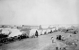
In 1901, the federal government allotted the lands of the Kiowa, Comanche and Arapaho Reservations, and opened the surplus land to white settlement. On August 6, 1901, an auction was held for homesteads and town lots. Around 5,000 people were living in "Rag Town" on the east edge of Anadarko awaiting the auction. Although 20,000 people were present for auction day, Anadarko's population dwindled to 2,190 in 1907.
Agriculture has been the principal driver of the local economy, since the Washita Valley has been good for crops and livestock. The second pillar of the local economy has been Indian affairs.
Geography
Climate
| Climate data for Anadarko, Oklahoma | |||||||||||||
|---|---|---|---|---|---|---|---|---|---|---|---|---|---|
| Month | Jan | Feb | Mar | Apr | May | Jun | Jul | Aug | Sep | Oct | Nov | Dec | Year |
| Average high °F (°C) | 49 (9) |
55 (13) |
62 (17) |
71 (22) |
88 (31) |
88 (31) |
93 (34) |
93 (34) |
85 (29) |
74 (23) |
61 (16) |
50 (10) |
72 (22) |
| Average low °F (°C) | 23 (−5) |
28.7 (−1.8) |
35 (2) |
44 (7) |
56 (13) |
65 (18) |
70 (21) |
68 (20) |
59 (15) |
47 (8) |
35 (2) |
25 (−4) |
46.3 (7.9) |
| Average precipitation inches (mm) | 1.14 (29) |
1.67 (42) |
2.61 (66) |
2.77 (70) |
4.89 (124) |
4.52 (115) |
2.46 (62) |
2.81 (71) |
3.12 (79) |
3.68 (93) |
1.97 (50) |
1.67 (42) |
33.31 (846) |
| Source: Weatherbase.com | |||||||||||||
Demographics
| Historical population | |||
|---|---|---|---|
| Census | Pop. | %± | |
| 1910 | 3,439 | — | |
| 1920 | 3,116 | −9.4% | |
| 1930 | 5,036 | 61.6% | |
| 1940 | 5,579 | 10.8% | |
| 1950 | 6,184 | 10.8% | |
| 1960 | 6,299 | 1.9% | |
| 1970 | 6,682 | 6.1% | |
| 1980 | 6,378 | −4.5% | |
| 1990 | 6,586 | 3.3% | |
| 2000 | 6,645 | 0.9% | |
| 2010 | 6,762 | 1.8% | |
| 2020 | 5,745 | −15.0% | |
| U.S. Decennial Census 2010 2020 | |||
As of the census of 2020, there were 5,745 people living in the city. The population density was 948.5 people per square mile (361.9/km2). There were 2,800 housing units at an average density of 390.2 per square mile (150.7/km2). The racial makeup of the city was 36% White, 40.4% Native American, 6% African American, 1.1% Asian, 11.2% Hispanic or Lationo, and 14.7% from two or more races.
Culture
Anadarko is the home of the Native American drum group Cozad Singers.
Native American significance
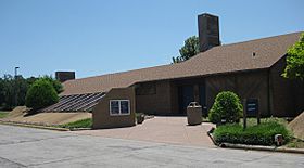
Anadarko, self-titled, "Indian Capital of the Nation," is home to the annual American Indian Exposition. It is one of two places in Oklahoma where a Lenape tribe is headquartered, the other being Bartlesville. The city houses the National Hall of Fame for Famous American Indians.
Anadarko is named after the Nadaco, a Caddo band now affiliated with the Caddo Nation. In the Caddo language, Nadá-kuh, means "bumblebee place". The Caddo are a federally recognized American Indian tribe for which Caddo County is named; Caddo County is part of the former reservation of the Caddo, Wichita, and Western Delaware, prior to allotment in the post-Dawes Allotment Era.
Culturally, Anadarko is rare among Oklahoma cities as Native Americans form a near-majority. Locals are often familiar with a few basic Indian words, such as haw-nay, Kiowa for "no." Wichita and Apache words are sometimes employed in casual conversation as well, such as hangy, ah-ho, ebote, and bocote. Indian motifs are commonly used for design, art, and other aspects of daily life.
Anadarko has a Bureau of Indian Affairs office. The town is situated between the Wichita, Caddo, and Delaware reservations to the north, and the Kiowa, Comanche, and Apache reservations to the south. These reservations, along with all but the Osage Reservation in northeastern Oklahoma, were dismantled by the allotment of tribal lands to individual members, and the opening of the "excess" lands to settlement, in a series of land openings. The area surrounded by Anadarko was opened to settlement by a 1901 land lottery affecting the Kiowa, Comanche, Wichita and Caddo lands.
Anadarko is home to Riverside Indian School, a Bureau of Indian Education boarding and day school for Native American students. Indian City USA cultural center, now owned by the Kiowa Tribe, is located 2–1/2 miles southeast of Anadarko. Indian City is now closed; it is yet to decide when it will re-open.
Education
Anadarko Public Schools consists of three elementary schools, Sunset Elementary, East Elementary, and Mission Elementary; a middle school; and a high school. There are approximately 1,950 students.
Riverside Indian School is near Anadarko.
Notable people
- Richard Aitson (b. 1953), a Kiowa-Kiowa Apache bead artist, curator, and poet
- Black Beaver (1806—1880), Delaware Native American leader, scout, and rancher
- Blackbear Bosin (1921-1980), Comanche-Kiowa artist
- Ronald D. Godard, ambassador
- Derrell Griffith (b. 1943), former Major League Baseball player
- Ralph B. Hodges (1930-2013), former Chief Justice of the Oklahoma Supreme Court
- Genta H. Holmes (b. 1940), first United States Ambassador to Namibia
- Butch Huskey (b. 1971), former Major League Baseball player
- Charles Leonhard (1915-2002), music educator and academic
- Doris McLemore (1927–2016) last fluent speaker of the Wichita language
- Cal McLish (1925-2010), Major League Baseball player
- Stephen Mopope (1900-1974), Kiowa artist
- Gary Nixon (1941-2011), national champion motorcycle racer
- Ray Gene Smith (1928–2005), football player
- Jim Thompson (1906-1977), author and screenwriter
- Gene Tracy (1927–1979), comedian, emcee, and recording artist
- Louis Weller (1904-1979), National Football League player
See also
 In Spanish: Anadarko (Oklahoma) para niños


