Anegada Passage facts for kids
Quick facts for kids Anegada Passage |
|
|---|---|

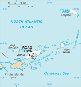
Map of the British Virgin Islands, with the Anegada Passage labeled at right side.
|
|
| Coordinates | 18°22′41″N 63°50′15″W / 18.37806°N 63.83750°W |
| Basin countries | British Virgin Islands Anguilla |
| Max. length | 200 kilometres (120 mi) |
| Max. width | 65 kilometres (40 mi) |
| Average depth | 2,300 metres (7,500 ft) |
Anegada Passage is a strait in the Caribbean that separates the British Virgin Islands and the British ruled Sombrero Island of Anguilla, and connects the Caribbean and the Atlantic Ocean. It is 2300 m deep. Because the threshold depths are 1800 and 1600 m, Atlantic deep water from 1600 m level may flow into the deep areas in the Caribbean Sea.
The Anegada Passage is a key shipping lane for the Panama Canal. Often called the "Oh-my-god-a Passage", it is considered a difficult passage for sailors because of the winds, waves, and swells.
The passage consists of multiple basins and ridges. The Anegada Trough or Virgin Islands Basin was the likely site of the 1867 Virgin Islands earthquake and subsequent tsunami.

All content from Kiddle encyclopedia articles (including the article images and facts) can be freely used under Attribution-ShareAlike license, unless stated otherwise. Cite this article:
Anegada Passage Facts for Kids. Kiddle Encyclopedia.


