
Annette Island facts for kids


Annette Island or Taak'w Aan (Tlingit) is an island in the Gravina Islands of the Alexander Archipelago of the Pacific Ocean on the southeastern coast of the U.S. state of Alaska. It is at 55°08′06″N 131°27′21″W / 55.13500°N 131.45583°W. It is about 18 km (11 mi) long and about 18 km (11 mi) wide. The land area is 332.573 km2 (128.407 sq mi). Annette Island is located west across the Revillagigedo Channel from the Alaska mainland and south of Revillagigedo Island. The Island was named in 1879 by William Healey Dall, an American naturalist and explorer in Alaska, in honor of his wife Annette Whitney Dall.
The meaning of the Tlingit name for the island is Winter Town. Since the late 19th century, it has been the base of the Annette Island Reserve of the Metlakatla Alaska Native Community, composed mostly of Tsimshian people. This is the only remaining Indian reservation in Alaska, as the Metlakatla voted to opt out of giving up their lands under the Alaska Native Claims Settlement Act of the 1970s. In 2016 they elected Audrey Hudson as their first Tribal Chairwoman.
Contents
Demographics
| Historical population | |||
|---|---|---|---|
| Census | Pop. | %± | |
| 1950 | 302 | — | |
| 1960 | 337 | 11.6% | |
| 1970 | 195 | −42.1% | |
| 1980 | 139 | −28.7% | |
| 1990 | 43 | −69.1% | |
| U.S. Decennial Census | |||
Annette first appeared on the 1950 U.S. Census as an unincorporated village. In 1980, it was made a census-designated place (CDP). It last returned in 1990 and was dissolved as a CDP effective as of the 2000 census.
Climate
The lower elevations of Annette Island have a Marine west coast climate (Köppen Cfb), with windy and wet weather year-round, cool winters, and mild summers, and straddle the border between USDA Plant Hardiness Zones 7 and 8. Due to its southerly and maritime location, with an annual mean temperature of 46.6 °F (8.1 °C), the Annette Island Airport is one of the warmest locations statewide. Precipitation falls on most days during the winter, and the seasonal total snowfall of 33.5 inches (85 cm) occurs mostly from November to March, with some accumulation during April. Snowfall in May and October is relatively rare; warm spells raise the high to 50 °F (10 °C) for several days each month. During summer, there is an average of 17 days with 70 °F (21 °C)+ highs, and rain still falls on around half of the days. Precipitation averages more than 101 inches (2.57 m) annually, with June and July being the driest months and October and November the wettest. Extreme temperatures have ranged from −4 °F (−20 °C) on January 30, 1947 up to 93 °F (34 °C) on June 19, 2004, with the temperature having fallen below 0 °F (−18 °C) only on a handful of occasions. In addition, the Annette Island Airport holds the Alaska state monthly record high temperatures for April (82 °F or 28 °C on April 29, 1976) and November (67 °F or 19 °C on November 1, 1970).
| Climate data for Annette Island Airport, Alaska (1981–2010 normals) | |||||||||||||
|---|---|---|---|---|---|---|---|---|---|---|---|---|---|
| Month | Jan | Feb | Mar | Apr | May | Jun | Jul | Aug | Sep | Oct | Nov | Dec | Year |
| Record high °F (°C) | 61 (16) |
65 (18) |
64 (18) |
82 (28) |
88 (31) |
93 (34) |
90 (32) |
90 (32) |
82 (28) |
71 (22) |
67 (19) |
62 (17) |
93 (34) |
| Average high °F (°C) | 41.6 (5.3) |
42.7 (5.9) |
44.9 (7.2) |
50.2 (10.1) |
56.3 (13.5) |
61.1 (16.2) |
64.3 (17.9) |
64.7 (18.2) |
59.3 (15.2) |
51.6 (10.9) |
44.6 (7.0) |
41.5 (5.3) |
51.9 (11.1) |
| Average low °F (°C) | 32.4 (0.2) |
32.7 (0.4) |
34.5 (1.4) |
38.2 (3.4) |
44.0 (6.7) |
49.2 (9.6) |
52.9 (11.6) |
53.1 (11.7) |
48.4 (9.1) |
41.9 (5.5) |
35.4 (1.9) |
32.8 (0.4) |
41.3 (5.2) |
| Record low °F (°C) | −4 (−20) |
2 (−17) |
1 (−17) |
3 (−16) |
30 (−1) |
37 (3) |
40 (4) |
40 (4) |
30 (−1) |
18 (−8) |
−3 (−19) |
1 (−17) |
−4 (−20) |
| Average precipitation inches (mm) | 10.73 (273) |
7.30 (185) |
8.04 (204) |
6.77 (172) |
5.56 (141) |
4.88 (124) |
4.64 (118) |
6.95 (177) |
9.79 (249) |
13.92 (354) |
12.29 (312) |
10.72 (272) |
101.61 (2,581) |
| Average snowfall inches (cm) | 7.8 (20) |
7.0 (18) |
6.5 (17) |
1.4 (3.6) |
0.1 (0.25) |
0 (0) |
0 (0) |
0 (0) |
0 (0) |
0.1 (0.25) |
3.3 (8.4) |
7.4 (19) |
33.5 (85) |
| Average precipitation days (≥ 0.01 in) | 22.1 | 17.6 | 21.6 | 18.8 | 15.9 | 15.4 | 14.9 | 15.8 | 18.7 | 23.6 | 23.6 | 23.0 | 231.0 |
| Average snowy days (≥ 0.1 in) | 5.4 | 4.5 | 4.7 | 1.6 | 0.2 | 0 | 0 | 0 | 0 | 0.1 | 2.8 | 4.6 | 23.9 |
| Average relative humidity (%) | 77.1 | 78.1 | 75.4 | 75.4 | 74.9 | 77.0 | 78.6 | 80.8 | 81.6 | 81.5 | 79.1 | 78.8 | 78.2 |
| Mean monthly sunshine hours | 49.6 | 70.6 | 105.4 | 147.0 | 186.0 | 162.0 | 148.8 | 145.7 | 108.0 | 68.2 | 51.0 | 34.1 | 1,276.4 |
| Mean daily sunshine hours | 1.6 | 2.5 | 3.4 | 4.9 | 6.0 | 5.4 | 4.8 | 4.7 | 3.6 | 2.2 | 1.7 | 1.1 | 3.5 |
| Source 1: NOAA (extremes 1941–present, humidity 1961–1990) | |||||||||||||
| Source 2: Deutscher Wetterdienst (sun 1961–1990) | |||||||||||||
Infrastructure
A network of unimproved roads and trails on the island were developed during years of logging. More than 50 years after the United States made a treaty with the Metlakatla Community that promised a cross-island road in exchange for their allowing construction and operation of an airfield on the island, it made good on its word. A joint armed forces task force constructed a 15-mile road across the island, completed from 1997 to 2007, which connected Metlakatla on the ocean side to the side facing Ketchikan, where a ferry landing has been built. This has improved access by ferry to the mainland.
After the Second World War, the airfield was used as a United States Coast Guard Search and Rescue base. It served commercial aircraft as well until the 1970s, when the new Ketchikan Airport was built at Gravina Island in the Inside Passage.
Images for kids
-
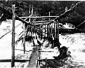
Fish trap on Tamgas Stream, Annette Island, July 1910
-
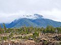
Annette Island landscape
.jpeg)

