
Arkansas County, Arkansas facts for kids
Quick facts for kids
Arkansas County
|
|
|---|---|

Clockwise from top: a rice field on the Grand Prairie, the Yancopin Bridge over the Arkansas River, the Southern District Courthouse in DeWitt, the Northern District Courthouse in Stuttgart, Arkansas
|
|

Location within the U.S. state of Arkansas
|
|
 Arkansas's location within the U.S. |
|
| Country | |
| State | |
| Founded | December 13, 1813 |
| Named for | Arkansas River |
| Seat | Stuttgart (north district); De Witt (south district) |
| Largest city | Stuttgart |
| Area | |
| • Total | 1,033.79 sq mi (2,677.5 km2) |
| • Land | 988.49 sq mi (2,560.2 km2) |
| • Water | 45.30 sq mi (117.3 km2) 4.4%% |
| Population
(2010)
|
|
| • Total | 19,019 |
| • Estimate
(2019)
|
17,486 |
| • Density | 18.3974/sq mi (7.10326/km2) |
| Time zone | UTC−6 (Central) |
| • Summer (DST) | UTC−5 (CDT) |
| Congressional district | 1st |
Arkansas County is a county located in the U.S. state of Arkansas. As of the 2010 census, the population was 19,019. Located in the Arkansas Delta, the county has two county seats, DeWitt and Stuttgart.
The first of the state's 75 present-day counties to be created, Arkansas County was formed on December 13, 1813, when this area was part of the Missouri Territory. The county was named after the Arkansas River (itself named for the Arkansas tribe), as was the subsequent Arkansas Territory. This was later split off from Missouri Territory and eventually admitted to the union as a state. The riverfront areas in the Arkansas Delta were developed for cotton plantations, based on the use of enslaved African Americans. Cotton was the major commodity crop before and after the Civil War. Other crops such as soybeans are also cultivated now, in industrial-scale production.
Arkansas County is one of seven present-day counties in the United States that have the same name as the state in which they are located.
Contents
Geography
According to the U.S. Census Bureau, the county has a total area of 1,034 square miles (2,680 km2), of which 989 square miles (2,560 km2) is land and 45 square miles (120 km2) (4.4%) is water. It is the third-largest county in Arkansas by area.
Adjacent counties
- Prairie County (north)
- Monroe County (northeast)
- Phillips County (east)
- Desha County (south)
- Lincoln County (southwest)
- Jefferson County (west)
- Lonoke County (northwest)
National protected areas
Demographics
The peak of population in the rural county was 1940. Mechanization and industrial-scale agriculture reduced the number of farm workers, and people have moved away because of the lack of opportunities.
| Historical population | |||
|---|---|---|---|
| Census | Pop. | %± | |
| 1830 | 1,426 | — | |
| 1840 | 1,346 | −5.6% | |
| 1850 | 3,245 | 141.1% | |
| 1860 | 8,844 | 172.5% | |
| 1870 | 8,268 | −6.5% | |
| 1880 | 8,038 | −2.8% | |
| 1890 | 11,432 | 42.2% | |
| 1900 | 12,973 | 13.5% | |
| 1910 | 16,103 | 24.1% | |
| 1920 | 21,483 | 33.4% | |
| 1930 | 22,300 | 3.8% | |
| 1940 | 24,437 | 9.6% | |
| 1950 | 23,665 | −3.2% | |
| 1960 | 23,355 | −1.3% | |
| 1970 | 23,347 | 0.0% | |
| 1980 | 24,175 | 3.5% | |
| 1990 | 21,653 | −10.4% | |
| 2000 | 20,749 | −4.2% | |
| 2010 | 19,019 | −8.3% | |
| 2020 | 17,149 | −9.8% | |
| U.S. Decennial Census 1790–1960 1900–1990 1990–2000 2020 |
|||
2020 Census
| Race | Number | Percentage |
|---|---|---|
| White (non-Hispanic) | 11,575 | 67.5% |
| Black or African American (non-Hispanic) | 4,138 | 24.13% |
| Native American | 34 | 0.2% |
| Asian | 94 | 0.55% |
| Pacific Islander | 9 | 0.05% |
| Other/Mixed | 663 | 3.87% |
| Hispanic or Latino | 636 | 3.71% |
As of the 2020 United States census, there were 17,149 people, 7,491 households, and 4,723 families residing in the county.
2010 Census

Racial/Ethnic Makeup of Arkansas County treating Hispanics as a Separate Category (2018) White Non-Hispanic (70.0%) Black Non-Hispanic (25.8%) Native American Non-Hispanic (0.1%) Asian Non-Hispanic (0.0%) Pacific Islander Non-Hispanic (0.0%) Other Non-Hispanic (0.0%) Two or more races Non-Hispanic (1.0%) Hispanic Any Race (3.1%)
As of the 2010 census, there were 19,019 people, 8,005 households, and 5,306 families residing in the county. The population density was 18 people per square mile (7/km2). There were 9,436 housing units at an average density of 9 per square mile (4/km2). The racial makeup of the county was 71.8% White, 24.5% Black or African American, 0.5% Asian, 0.2% Native American, 0% Pacific Islander, 1.7% from other races, and 1.3% from two or more races. 2.7% of the population were Hispanic or Latino of any race.
There were 8,005 households, out of which 30.9% had children under the age of 18 living with them, 46.4% were married couples living together, 15.3% had a female householder with no husband present, and 33.7% were non-families. 29.4% of all households were made up of individuals, and 12.6% had someone living alone who was 65 years of age or older. The average household size was 2.35 and the average family size was 2.87.
In the county, the population was spread out, with 23.3% under the age of 18, 7.6% from 18 to 24, 24.2% from 25 to 44, 28.6% from 45 to 64, and 16.5% who were 65 years of age or older. The median age was 40.7 years. For every 100 females there were 94.1 males. For every 100 females age 18 and over, there were 90.9 males.
The median income for a household in the county was $37,230, and the median income for a family was $48,698. Males had a median income of $37,489 versus $25,607 for females. The per capita income for the county was $22,142. About 13.1% of families and 18.9% of the population were below the poverty line, including 21.5% of those under age 18 and 16.7% of those age 65 or over.
In 2010, the largest denominational group was the Evangelical Protestants (with 7,709 adherents) and Mainline Protestants (with 2,500 adherents). Almost 29% of people in the county did not claim a religious tradition. The largest religious bodies were The Southern Baptist Convention (with 6,332 members) and The United Methodist Church (with 1,976 members).
Infrastructure
Aviation

The county contains two public owned/public use airports: Almyra Municipal Airport and DeWitt Municipal Airport. Both are small, rural airports with over 50,000 annual operations, almost entirely agricultural spraying operations. Stuttgart Municipal Airport is located north of the city, in Prairie County. Arkansas County also contains 16 private airfields.
Major highways
 US Route 63
 US Route 79
 US Route 165
 Highway 1
 Highway 11
 Highway 17
 Highway 33
 Highway 44
 Highway 130
 Highway 144
 Highway 146
 Highway 152
 Highway 153
 Highway 169
 Highway 276
 Highway 343
 Highway 980
Communities
Cities
Towns
Townships

Townships in Arkansas are the divisions of a county. Each township includes unincorporated areas; some may have incorporated cities or towns within part of their boundaries. Arkansas townships have limited purposes in modern times. However, the United States Census does list Arkansas population based on townships (sometimes referred to as "county subdivisions" or "minor civil divisions"). Townships are also of value for historical purposes in terms of genealogical research. Each town or city is within one or more townships in an Arkansas county based on census maps and publications. The townships of Arkansas County are listed below; listed in parentheses are the cities, towns, and/or census-designated places that are fully or partially inside the township.
Images for kids
-
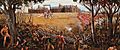
Depiction of the Battle of Arkansas Post, the only battle of the American Revolution fought in Arkansas
-
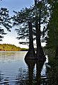
Bald cypress trees along the shores of Lower White Lake
-
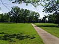
A "ghost" townsite is laid out at Arkansas Post National Memorial, marking original locations of homes, blacksmith shops, and the first state capitol
-
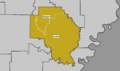
Public school district boundaries in Arkansas County as of July 2016
-
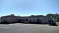
William F. Foster Library in Stuttgart
-
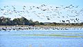
Waterfowl near Bayou Meto
-
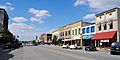
Streetside in Stuttgart


See also
 In Spanish: Condado de Arkansas para niños
