
Arlington, Massachusetts facts for kids
Quick facts for kids
Arlington, Massachusetts
|
||
|---|---|---|

Ice Harvesting on Spy Pond, from an 1854 Print.
|
||
|
||
| Motto(s):
Libertatis Propugnatio Hereditas Avita (Latin)
"The Defense of Liberty Is Our Ancestral Heritage" |
||

Location in Massachusetts
|
||

Arlington, Massachusetts
Location in Massachusetts

Arlington, Massachusetts
Location in the United States

Arlington, Massachusetts
Location in North America
|
||
| Country | United States | |
| State | Massachusetts | |
| County | Middlesex | |
| Settled | 1635 | |
| Incorporated | 1807 | |
| Renamed | 1867 | |
| Government | ||
| • Type | Representative town meeting | |
| Area | ||
| • Total | 5.495 sq mi (14.235 km2) | |
| • Land | 5.048 sq mi (13.077 km2) | |
| • Water | 0.447 sq mi (1.158 km2) | |
| Elevation | 46 ft (14 m) | |
| Population
(2020)
|
||
| • Total | 46,308 | |
| • Density | 9,173.53/sq mi (3,541.18/km2) | |
| Time zone | UTC−5 (Eastern) | |
| • Summer (DST) | UTC−4 (Eastern) | |
| ZIP Codes |
02474, 02476
|
|
| Area code(s) | 339 / 781 | |
| FIPS code | 25-01605 | |
| GNIS feature ID | 0619393 | |
| Website | www.arlingtonma.gov | |


Arlington is a town in Middlesex County, Massachusetts, United States, six miles (10 km) northwest of Boston. The population was 46,308 at the 2020 census.
Contents
History

The Town of Arlington was settled by European colonists in 1635 as a village within the boundaries of Cambridge, Massachusetts under the name Menotomy, an Algonquian word meaning "swift running water". A larger area, including land that was later to become the town of Belmont, and outwards to the shore of the Mystic River, which had previously been part of Charlestown, was incorporated on February 27, 1807 as West Cambridge. In 1867, the name "Arlington" was chosen in honor of those buried in Arlington National Cemetery; the name change took effect that April 30.
The Massachusett tribe, part of the Algonquian group of Native Americans, lived around the Mystic Lakes, the Mystic River and Alewife Brook. By the time Europeans arrived, the local Indians had been devastated by disease; also, the tribal chief, Nanepashemet, had been killed by a rival tribe in about 1619. Nanepashemet's widow, known to history only as "Squaw Sachem", sold the land of her tribe to the colonists for ten pounds, with provisions that she and her tribe could remain on her homestead land around the Mystic Lakes and continue hunting and farming. She also was to be given a new winter coat of wool each year for the rest of her life. She is thought to have lived until about 1650.

Through the town also flows the stream called Mill Brook, which historically figured largely into Arlington's economy. In 1637 Captain George Cooke built the first mill in this area. Subsequently, seven mills were built along the stream, including the Old Schwamb Mill, which survives to this day. The Schwamb Mill has been a working mill since 1650, making it the longest working mill in the country.
Paul Revere's famous midnight ride to alert colonists took him through Menotomy, now known as Arlington. Later on that first day of the American Revolution, more blood was shed in Menotomy than in the battles of Lexington and Concord combined. Minutemen from surrounding towns converged on Menotomy to ambush the British on their retreat from Concord and Lexington. All in all, 25 colonials were killed in Menotomy (half of all Americans killed in the day's battles), as well as 40 British troops (more than half their fatalities).
_map.jpg)
The Jason Russell House, a yellow colonial, is today a museum which remembers those twelve Americans, including Russell himself, who were killed in and around this pictured dwelling on April 19, 1775. Bullet holes are visible in the interior walls to this day.
In its early years, Arlington was a thriving farming community and had its own lettuce that was quite popular.
Arlington had a large ice industry on Spy Pond from the mid-19th century until the last ice house burned down in 1930; much of its ice was sent to the Caribbean and India by "Ice King" Frederic Tudor.
Arlington's population grew by over 90 percent during the 1920s.
In 1979, the first spreadsheet software program, VisiCalc, was developed by Bob Frankston and Dan Bricklin in the attic of the Arlington apartment rented by Bob Frankston.
Arlington was the site of the accident which claimed the life of top American professional cyclist Nicole Reinhart, a two-time Pan American Games winner. She was killed on September 17, 2000 when she was thrown from her bicycle during a National Calendar criterium bicycle race.

Geography
Arlington covers 3,517.5 acres (14 km2), or 5.5 square miles, of which 286.2 acres (1.2 km2) are covered by water. There are 210.52 acres (0.9 km2) of parkland. Elevation ranges from 4 feet (1.2 m) above sea level (along Alewife Brook) to 377 feet (114.9 m) near Park Avenue and Eastern Avenue.
Arlington borders on the Mystic Lakes, Mystic River, and Alewife Brook. Within its borders are Spy Pond, the Arlington Reservoir, Mill Brook, and Hills Pond.
Neighborhoods
- Arlington Center
- Arlington Heights, in the west
- East Arlington, roughly east of Pleasant Street
- Brattle Square
- Jason Heights
- Arlmont Village
- Morningside
- Turkey Hill
Adjacent municipalities
Arlington is located in eastern Massachusetts and is bordered by the cities of Medford to the northeast, Somerville to the east, Cambridge to the southeast, and the towns of Winchester to the north, Lexington to the west, and Belmont to the south.
Demographics
| Historical population | ||
|---|---|---|
| Year | Pop. | ±% |
| 1850 | 2,202 | — |
| 1860 | 2,681 | +21.8% |
| 1870 | 3,261 | +21.6% |
| 1880 | 4,100 | +25.7% |
| 1890 | 5,029 | +22.7% |
| 1900 | 8,603 | +71.1% |
| 1910 | 11,187 | +30.0% |
| 1920 | 18,665 | +66.8% |
| 1930 | 36,094 | +93.4% |
| 1940 | 40,013 | +10.9% |
| 1950 | 44,353 | +10.8% |
| 1960 | 49,953 | +12.6% |
| 1970 | 53,524 | +7.1% |
| 1980 | 48,219 | −9.9% |
| 1990 | 44,630 | −7.4% |
| 2000 | 42,389 | −5.0% |
| 2010 | 42,844 | +1.1% |
| 2020 | 46,308 | +8.1% |
| * = population estimate. Source: United States Census records and Population Estimates Program data. | ||
At the 2010 census, there were 42,844 people, 18,969 households and 10,981 families residing in the town. The population density was 8,239.2 per square mile (3,197.3/km2). There were 19,974 housing units at an average density of 3,841.2 per square mile (1,490.6/km2). The racial makeup of the town was 83.6% White, 2.3% African American, 0.1% Native American, 8.3% Asian, 0.4% from other races, and 2.1% from two or more races. Hispanic or Latino of any race were 3.3% of the population.
There were 19,007 households, of which 27.0% had children under the age of 18 living with them, 45.1% were married couples living together, 2.0% had a male householder with no wife present, 9.9% had a female householder with no husband present, and 43.0% were non-families. 35.1% of all households were made up of individuals, and 11.2% had someone living alone who was 65 years of age or older. The average household size was 2.23 and the average family size was 2.93.
Of the 42,844 people in the population, 21.4% were under the age of 18, 5.8% were 15 to 19 years of age, 5.3% were 20 to 24 years of age, 30.3% were 25 to 44 years of age, 28.7% were 45 to 64 years of age, and 15.8% were 65 years and over. The median age was 41.7 years. For every 100 females, there were 86.8 males. For every 100 females 18 years and over there were 83.9 males.
The median household income was $85,059, and the median family income was $107,862. The median income of individuals working full-time was $78,820 for males versus $64,143 for females. The per capita income for the town was $47,571. About 1.9% of families and 4.4% of the population were below the poverty line, including 2.3% of those under age 18 and 7.5% of those age 65 or over.
Income
Data is from the 2009–2013 American Community Survey 5-Year Estimates.
| Rank | ZIP Code (ZCTA) | Per capita income |
Median household income |
Median family income |
Population | Number of households |
Poverty Rate |
|---|---|---|---|---|---|---|---|
| 1 | 02476 (Arlington Center/Heights) | $51,709 | $95,305 | $131,770 | 16,662 | 7,065 | N/a |
| Arlington | $49,549 | $89,841 | $117,590 | 43,308 | 18,688 | 4.4% | |
| 2 | 02474 (East Arlington) | $48,199 | $87,225 | $111,148 | 26,646 | 11,623 | N/a |
| Middlesex County | $42,861 | $82,090 | $104,032 | 1,522,533 | 581,120 | 7.7% | |
| Massachusetts | $35,763 | $66,866 | $84,900 | 6,605,058 | 2,530,147 | 10.7% | |
| United States | $28,155 | $53,046 | $64,719 | 311,536,594 | 115,610,216 | 15.1% |
Parks and historical sites


- Menotomy Rocks Park encompasses Hills Pond and has trails through the surrounding forested land.
- Robbins Farm Park along Eastern Avenue includes a playground, ball fields, and a commanding view of the Boston skyline.
- Robbins Library contains the oldest continuously operated free children's library in the country.
- Spy Pond Park provides access to the northeast shore of Spy Pond.
- The Arlington Center Historic District, where the Robbins Library and Old Burying Ground are located, is on the National Register of Historic Places.
- The Cyrus E. Dallin Art Museum is a site dedicated to the artwork and sculpture of noted artist Cyrus E. Dallin.
- The Great Meadow comprises both wet meadow swamp and forest right outside the border of Arlington. While the Great Meadow lies within the borders of Lexington, the park is owned and maintained by the Town of Arlington.
- The House at 5 Willow Court
- The Henry Swan House, built in 1888, is a historic house at 418 Massachusetts Avenue. It was added to the National Register of Historic Places in 1985.
- The Jason Russell House contains a museum that displays, among other items, a mastodon tusk found in Spy Pond in the late 1950s by a fisherman who originally thought he had brought up a tree branch.
- The Minuteman Bikeway, a popular rail trail built in 1992, passes through various Arlington neighborhoods, including Arlington Center.
- The Prince Hall Mystic Cemetery, the only black Freemason Cemetery in the country.
- The Uncle Sam Memorial Statue commemorates native son Samuel Wilson, who was perhaps the original Uncle Sam.
- The Water tower at Park Circle is an exact copy of the rotunda of the ancient Greek Arsinoeon of the Samothrace temple complex.
Arlington in popular culture
- Two feature films have been shot partially in Arlington: The Out-of-Towners, starring Steve Martin and Goldie Hawn, and Once Around, starring Richard Dreyfuss and Holly Hunter.
- Three widely recognized television shows have been filmed in Arlington: This Old House, Trading Spaces, and Made.
- A History Channel special, Bible Battles, was filmed in Arlington.
- Arlington is referenced in the movie The Verdict starring Paul Newman. South Boston's K Street takes the place of Arlington in the movie.
- The music video for "Sing" by The Dresden Dolls was shot at the Regent Theatre in Arlington Center.
- Arlington High School received national media attention, becoming a topic of interest for the Glenn Beck Show and The View, for a ruling of the Arlington School Committee concerning the Pledge of Allegiance.
- Arlington High School's 2014 Jazz Band came in 2nd place in the International Berklee High School Jazz Festival
- Arlington High School's 2013 Octet won the International Berklee High School Jazz Festival
- Arlington High School's 2011 Jazz Band came in 2nd place in the International Berklee High School Jazz Festival by 1 point
- Arlington High School's quiz team has appeared in two seasons of WGBH's High School Quiz Show.
- The Steve Katsos Show is filmed at ACMi Studios in Arlington Heights.
- Arlington's Little League baseball team won the Massachusetts State Little League championship in 1971.
Organizations based in Arlington

- Arlington Garden Club
- Arlington Democratic Town Committee
- Arlington Republican Town Committee
- The Menotomy Bird Club
- Arlington Friends of the Drama
- Arlington Dog Owners Group
- The Armenian Cultural Foundation
- Mystic Valley Lodge, A.F.& A.M.
Sister cities
 Teosinte, El Salvador
 Portarlington, County Laois, Ireland
 Nagaokakyo, Kyoto, Japan
Education
Public schools
Arlington has a public school system with ten schools. (7 elementary schools, 2 middle schools, and 1 high school) The seven elementary schools (K–5) are Brackett, Bishop, Dallin, Hardy, Peirce, Stratton, and Thompson. There are also two middle schools, grade 6 at Gibbs, and grades 7–8 at Ottoson, and Arlington High School, which includes grades 9–12. In addition, Arlington is in the district served by the Minuteman Regional High School, located in Lexington, one of the top vocational-technical schools in Massachusetts.
Private and parochial schools
There are two Parochial schools, Arlington Catholic High School, and an elementary/middle school, St. Agnes School, both affiliated with St. Agnes Parish. In addition, there are two secular elementary schools, Lesley Ellis and the Alivia Elementary School.
Supplementary schools
The Greater Boston Japanese Language School (ボストン補習授業校, Bosuton Hoshū Jugyō Kō), a supplementary school for Japanese people, has its weekday office in Arlington, while it holds classes at Medford High School in Medford.
Notable people

- Sven Birkerts (born 1951), essayist and literary critic
- Paul Boudreau, former NFL offensive line coach for the St. Louis Rams
- John Quincy Adams Brackett, Former Massachusetts Governor
- William Stanley Braithwaite, writer, poet and literary critic. Won Spingarn Medal in 1918
- Christopher Castellani, writer
- Andrew Chaikin, space journalist and author of A Man on the Moon, on which HBO based a miniseries
- Haroutioun Hovanes Chakmakjian, chemistry professor, Armenian scholar, and father of Alan Hovhaness
- Pat Connaughton, Current NBA Player for Milwaukee Bucks
- Dane Cook, comedian & actor
- Robert Creeley (1926–2005), poet
- Cyrus E. Dallin (1861–1944), sculptor; best known for the Appeal to the Great Spirit sculpture in front of the Museum of Fine Arts, Boston
- Adio diBiccari, sculptor
- Joshua Eric Dodge, Wisconsin Supreme Court
- Olympia Dukakis (born 1931), actress, Academy Award winner
- Bob Frankston, co-inventor of Visicalc, the first electronic spreadsheet, at 231 Broadway
- Roy J. Glauber, Nobel Prize winner (Physics), 2005
- Katy Grannan, photographer
- George Franklin Grant, first black graduate of Harvard Dental School and inventor of a type of golf tee
- Deborah Henson-Conant, Grammy-nominated harpist
- Susan Hilferty, costume designer, Wicked
- Alan Hovhaness (1911–2000), composer
- Timothy Hutton, Actor, youngest winner of an Academy Award for Best Supporting Actor
- Anthony James (1942–2020), actor
- John A. "Johnny" Kelley, Boston Marathon winner, 1935 and 1945, Olympian athlete
- Richard Lennon, Roman Catholic Bishop of Cleveland
- J. C. R. Licklider (1915–1990), computer scientist
- Thomas Louis "Tom" Magliozzi, co-host of NPR's weekly radio show Car Talk
- Raymond Francis "Ray" Magliozzi, co-host of NPR's weekly radio show Car Talk
- Elaine J. McCarthy projection designer for Broadway and opera
- William J. McCarthy, President of the International Brotherhood of Teamsters (IBT)
- Eugene Francis McGurl, US Army Air Forces 95th Bomb Sq., 17th Bomb Grp Navigator who flew with Crew 5 in General Jimmy Doolittle's famous "Thirty Seconds over Tokyo" raid in World War II
- Tom McNeeley, Jr., former heavyweight contender who challenged Floyd Patterson for the heavyweight title in Toronto in 1961
- John Messuri, Princeton College hockey player
- Eileen Myles, poet, novelist
- Jordan Peterson, Canadian clinical psychologist and professor of psychology at the University of Toronto. Lived in Arlington between 1993 and 1998 while teaching at Harvard University
- David Powers, former Special Assistant to US President John F. Kennedy
- Hilary Putnam (1926–2016), philosopher, mathematician and computer scientist, professor emeritus at Harvard
- Warren Winn Rawson, market gardener and seed distributor
- Herb Reed, vocalist and founding member of The Platters
- Miles Robinson, current professional soccer player for Atlanta United
- Dave "Chico" Ryan, bassist of Sha Na Na
- Whitney Smith, vexillologist and designer of the flag of Guyana
- Chris Smither, blues guitarist/singer.
- Bill Squires, American Track & Field Coach
- Mark J. Sullivan, Director of the United States Secret Service
- John Townsend Trowbridge (1827–1916), writer
- Samuel Whittemore, elderly soldier in the Battle of Lexington and Concord
- Alan Wilson (1943–1970), also known as Alan "Blind Owl" Wilson; singer, songwriter, leader of Canned Heat
- Samuel Wilson (1766–1854), meat-packer, namesake of "Uncle Sam"
- Tom Yewcic, former quarterback with the Boston Patriots from 1961 to 1966, and former catcher for the Detroit Tigers; only person ever to play two professional sports at Fenway Park
Images for kids
-
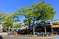
Arlington Center in 2019

See also
 In Spanish: Arlington (Massachusetts) para niños
