
Ashhurst facts for kids
Quick facts for kids
Ashhurst
Whārite (Māori)
|
|
|---|---|
| Motto(s):
image_map =
|
|
| Country | New Zealand |
| Region | Manawatū-Whanganui region |
| Territorial authority | Palmerston North City |
| Area | |
| • Total | 4.23 km2 (1.63 sq mi) |
| Population
(June 2023)
|
|
| • Total | 3,350 |
| • Density | 792.0/km2 (2,051/sq mi) |
| Postcode |
4810
|
Ashhurst (Māori: Whārite) is a town and outlying suburb of Palmerston North, in the Manawatū-Whanganui region of New Zealand's North Island.
Contents
Location
Ashhurst is sited 14 kilometres northeast of the city of Palmerston North and a satellite community of the city.
The town stands under the Ruahine Ranges, beneath Wharite Peak, which is the most notable peak on the south end of the Ruahine Range, upon which is the television and radio transmitter.
Transport

Ashhurst's importance stems from its location at the western end of the Manawatu Gorge. As such, it was close to the easiest road and rail link between the east and west coasts of the southern North Island. However, the Gorge has been closed since April 2017 and the road link to the east coast from Ashhurst is now via Saddle Road.
There are four buses on weekdays and one on Saturdays linking Palmerston North with Ashhurst.
Parks and Reserves
- Ashhurst Domain - A large multipurpose park which includes a camping ground, a lookout to the wind farm, a cemetery and canine area.
- Durham Street Reserve and McCraes Bush Reserve
- Lincoln Park - The home ground to the local rugby team Ashhurst-Pohangina RFC
History
Ashhurst was named for Lord Henry Ashhurst, who owned land in the immediate area. The Māori name for the area is Raukawa, after a native aromatic plant (Pseudopanax edgerleyi), whereas for the town it is Otangaki.
Notable people
- Andre Taylor, rugby player
- Mark McGrath, darts player
Demographics
| Historical population | ||
|---|---|---|
| Year | Pop. | ±% p.a. |
| 2006 | 2,433 | — |
| 2013 | 2,649 | +1.22% |
| 2018 | 2,934 | +2.06% |
Ashhurst, which covers 4.23 km2 (1.63 sq mi), had a population of 2,934 at the 2018 New Zealand census, an increase of 285 people (10.8%) since the 2013 census, and an increase of 501 people (20.6%) since the 2006 census. There were 1,074 households. There were 1,428 males and 1,506 females, giving a sex ratio of 0.95 males per female. The median age was 35.9 years (compared with 37.4 years nationally), with 726 people (24.7%) aged under 15 years, 492 (16.8%) aged 15 to 29, 1,320 (45.0%) aged 30 to 64, and 396 (13.5%) aged 65 or older.
Ethnicities were 89.0% European/Pākehā, 18.6% Māori, 3.1% Pacific peoples, 2.8% Asian, and 1.4% other ethnicities (totals add to more than 100% since people could identify with multiple ethnicities).
The proportion of people born overseas was 12.9%, compared with 27.1% nationally.
Although some people objected to giving their religion, 56.3% had no religion, 32.8% were Christian, 0.6% were Hindu, 0.1% were Buddhist and 2.0% had other religions.
Of those at least 15 years old, 384 (17.4%) people had a bachelor or higher degree, and 438 (19.8%) people had no formal qualifications. The median income was $34,300, compared with $31,800 nationally. The employment status of those at least 15 was that 1,179 (53.4%) people were employed full-time, 294 (13.3%) were part-time, and 66 (3.0%) were unemployed.
Education
Ashhurst School is a co-educational state primary school for Year 1 to 8 students, with a roll of 462 as of April 2023.
Images for kids
-
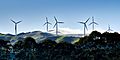
Te Apiti Wind Farm viewed from Ashhurst Domain

