
Ashland, Alabama facts for kids
Quick facts for kids
Ashland, Alabama
|
|
|---|---|
|
City
|
|

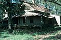
1st Street at dusk; Ashland, Alabama
|
|

Location of Ashland in Clay County, Alabama.
|
|

Ashland, Alabama
Location in Alabama

Ashland, Alabama
Location in the United States

Ashland, Alabama
Location in North America
|
|
| Country | United States |
| State | Alabama |
| County | Clay |
| Settled | 1867 |
| Incorporated | 1871 |
| Named for | Henry Clay's estate |
| Government | |
| • Type | Mayor/City Council |
| Area | |
| • Total | 7.38 sq mi (19.11 km2) |
| • Land | 7.35 sq mi (19.03 km2) |
| • Water | 0.03 sq mi (0.09 km2) |
| Elevation | 1,119 ft (341 m) |
| Population
(2020)
|
|
| • Total | 1,984 |
| • Density | 270.08/sq mi (104.28/km2) |
| Time zone | UTC-6 (Central (CST)) |
| • Summer (DST) | UTC-5 (CDT) |
| ZIP code |
36251
|
| Area code(s) | 256 |
| FIPS code | 01-02860 |
| GNIS feature ID | 0159091 |
| Website | http://www.cityofashland.net/ |
Ashland is a city in Clay County, Alabama, United States. The population was 2,037 at the 2010 census. The city is the county seat of Clay County.
Contents
History

Clay County was formed by an act of the Alabama General Assembly on December 7, 1866. Less than a year later, Ashland was established as the county seat on land donated by Hollingsworth Watts for the construction of a courthouse. Ashland was incorporated in 1871 and was named for 19th century statesman Henry Clay's Kentucky estate home.
During the early years, the town grew very rapidly. The town continued to grow with the opening of Alabama's first graphite mine in 1899. When World War I ended, the market for graphite dropped drastically, thus ending the town's growth phase.
The 1930s brought the Great Depression and boll weevil to Ashland that destroyed the cotton industry. Farmers were forced to abandon what had been the community's major industry. Timber, poultry, and cabinet making became the dominant industries by the beginning of the 21st century.
One of the newest attractions in Clay County in the 1920s, was the chicken business. Millions of chickens and eggs and long chicken houses In or about 1921, Reverend Secelar Claxton Ray took one hundred, day-old chicks to the Clay County Fair and put them under an oil burning brooder and called attention to the advantage of using chickens on the farm to supplement the 'all cotton' cash crop. This was something new, but it did gradually get the attention of the local farmers. He was now fully in the poultry business, and named it Goodwill Poultry Farm and Hatchery. He bought houses then idle at the local graphite mines in Clay County and hired neighbors in their spare time and built the hatchery and chicken houses and an extra tenant house on the farm, southeast of Ashland, Alabama whose population of close to one thousand had grown considerably from two hundred in 1881.
-
SC Ray Farm

Geography
Ashland is located at 33°16′20″N 85°50′13″W / 33.27222°N 85.83694°W (33.272206, −85.836925).
According to the U.S. Census Bureau, the city had a total area of 7.3 square miles (19 km2), of which 7.2 square miles (19 km2) is land and 0.04 square miles (0.10 km2) (0.41%) is water.
At 1,130 feet (340 m), Ashland is Alabama's highest elevated county seat.
Climate
The climate in this area is characterized by hot, humid summers and generally mild to cool winters. According to the Köppen Climate Classification system, Ashland has a humid subtropical climate, abbreviated "Cfa" on climate maps.
| Climate data for Ashland, Alabama | |||||||||||||
|---|---|---|---|---|---|---|---|---|---|---|---|---|---|
| Month | Jan | Feb | Mar | Apr | May | Jun | Jul | Aug | Sep | Oct | Nov | Dec | Year |
| Average high °C (°F) | 11 (52) |
14 (57) |
18 (65) |
23 (73) |
27 (80) |
30 (86) |
31 (88) |
31 (88) |
28 (83) |
23 (74) |
18 (64) |
13 (56) |
22 (72) |
| Average low °C (°F) | −1 (30) |
1 (33) |
4 (39) |
8 (47) |
13 (55) |
17 (63) |
19 (67) |
19 (66) |
16 (60) |
9 (48) |
4 (40) |
1 (33) |
9 (48) |
| Average precipitation mm (inches) | 140 (5.5) |
140 (5.6) |
170 (6.7) |
120 (4.6) |
110 (4.5) |
110 (4.4) |
140 (5.5) |
110 (4.2) |
110 (4.2) |
86 (3.4) |
110 (4.5) |
130 (5.1) |
1,480 (58.2) |
| Source: Weatherbase | |||||||||||||
Demographics
| Historical population | |||
|---|---|---|---|
| Census | Pop. | %± | |
| 1870 | 118 | — | |
| 1880 | 387 | 228.0% | |
| 1890 | 635 | 64.1% | |
| 1900 | 422 | −33.5% | |
| 1910 | 1,062 | 151.7% | |
| 1920 | 1,655 | 55.8% | |
| 1930 | 1,476 | −10.8% | |
| 1940 | 1,608 | 8.9% | |
| 1950 | 1,593 | −0.9% | |
| 1960 | 1,610 | 1.1% | |
| 1970 | 1,921 | 19.3% | |
| 1980 | 2,052 | 6.8% | |
| 1990 | 2,034 | −0.9% | |
| 2000 | 1,965 | −3.4% | |
| 2010 | 2,037 | 3.7% | |
| 2020 | 1,984 | −2.6% | |
| U.S. Decennial Census | |||
Ashland first appeared on the 1870 U.S. Census as an unincorporated village, incorporating as a town the following year. The 6th beat (precinct) of Clay County also bore the name of Ashland, and has continued to report to date (2010), becoming a census division in 1960. The population of the beat/precinct/census division is as follows: 1870–1,499; 1880–2,178; 1890–2,848; 1900–2,891; 1910–3,581; 1920–4,629; 1930–3,713; 1940–3,757; 1950–3,197; 1960–5,696; 1970–5,852; 1980–6,167; 1990–5,780; 2000–6,515; 2010–6,128. From 1870–1950, Ashland was also the largest community in Clay County. It lost that distinction to Lineville beginning in 1960, when the latter eclipsed Ashland by just 2 people (1,612 to 1,610).
2010 Census data
As of the census of 2010, there were 2,037 people, 849 households, and 516 families residing in the city. The population density was 272.9 inhabitants per square mile (105.4/km2). There were 986 housing units at an average density of 135 per square mile (52/km2). The racial makeup of the city was 71.5% White, 24.1% Black or African American, 0.7% Asian, 2.0% from other races, and 1.3% from two or more races. Hispanic or Latino of any race were 5.7% of the population.
There were 849 households, out of which 26.0% had children under the age of 18 living with them, 37.3% were married couples living together, 18.1% had a female householder with no husband present, and 39.2% were non-families. 37.2% of all households were made up of individuals, and 18.6% had someone living alone who was 65 years of age or older. The average household size was 2.22 and the average family size was 2.91.
In the city, the population was spread out, with 21.3% under the age of 18, 9.1% from 18 to 24, 24.3% from 25 to 44, 24.9% from 45 to 64, and 20.4% who were 65 years of age or older. The median age was 41.8 years. For every 100 females there were 84.8 males. For every 100 females age 18 and over, there were 90.1 males.
The median income for a household in the city was $30,759, and the median income for a family was $44,659. Males had a median income of $30,360 versus $29,438 for females. The per capita income for the city was $17,258. About 24.4% of families and 20.0% of the population were below the poverty line, including 7.9% of those under age 18 and 29.2 of those age 65 or over.
2020 Census data
| Race | Num. | Perc. |
|---|---|---|
| White (non-Hispanic) | 1,309 | 65.98% |
| Black or African American (non-Hispanic) | 503 | 25.35% |
| Native American | 3 | 0.15% |
| Asian | 25 | 1.26% |
| Pacific Islander | 1 | 0.05% |
| Other/Mixed | 77 | 3.88% |
| Hispanic or Latino | 66 | 3.33% |
As of the 2020 United States census, there were 1,984 people, 677 households, and 333 families residing in the town.
Notable natives
- Howard Ballard, former NFL player
- Hugo Black, Associate Justice of the Supreme Court of the United States from 1937 until 1971. His first law office was on the square in Ashland.
- Hiram Wesley Evans, Imperial Wizard of the Ku Klux Klan from 1922 to 1939.
- Bob Riley, Alabama's 52nd governor
Education
Public schools are:
-
Ashland Elementary School.
-
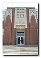
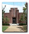
Clay County High School (Now Closed)


The current Central High School of Clay County and Central Junior High School are in Lineville.
According to the Alabama High School Athletic Association Clay County High School holds seven Class 2A championships.
- Football- 1994, 1995, 1996, 2000, 2005
- Boys basketball −1991, 1992
Additionally, CCHS was the 1-A State Football Champions in 2002
See also
 In Spanish: Ashland (Alabama) para niños
