
Asotin County, Washington facts for kids
Quick facts for kids
Asotin County
|
|
|---|---|

Asotin County Courthouse
|
|

Location within the U.S. state of Washington
|
|
 Washington's location within the U.S. |
|
| Country | |
| State | |
| Founded | October 27, 1883 |
| Seat | Asotin |
| Largest city | Clarkston |
| Area | |
| • Total | 641 sq mi (1,660 km2) |
| • Land | 636 sq mi (1,650 km2) |
| • Water | 4.4 sq mi (11 km2) 0.7%% |
| Population
(2020)
|
|
| • Total | 22,285 |
| • Estimate
(2021)
|
22,397 |
| • Density | 35/sq mi (14/km2) |
| Time zone | UTC−8 (Pacific) |
| • Summer (DST) | UTC−7 (PDT) |
| Congressional district | 5th |
Asotin County is a county in the U.S. state of Washington. As of the 2020 census, the population was 22,285. The county seat is at Asotin, and its largest city is Clarkston. The county was created out of Garfield County in 1883 and derives its name from a Nez Perce word meaning "Eel Creek." Asotin County is part of the Lewiston–Clarkston metropolitan area, which includes Nez Perce County, Idaho, and Asotin County.
Contents
Geography
According to the U.S. Census Bureau, the county has an area of 641 square miles (1,660 km2), of which 636 square miles (1,650 km2) is land and 4.4 square miles (11 km2) (0.7%) is water. It is the fifth-smallest county in Washington by area. It is part of the Palouse, a wide and rolling prairie-like region of the middle Columbia basin.
Geographic features
- Snake River
- Sagebrush
- Joseph Canyon
Major highways
 U.S. Route 12
Adjacent counties
- Whitman County - north
- Nez Perce County, Idaho - east
- Wallowa County, Oregon - south
- Garfield County - west
National protected area
- Umatilla National Forest (part)
Demographics
| Historical population | |||
|---|---|---|---|
| Census | Pop. | %± | |
| 1890 | 1,580 | — | |
| 1900 | 3,366 | 113.0% | |
| 1910 | 5,831 | 73.2% | |
| 1920 | 6,539 | 12.1% | |
| 1930 | 8,136 | 24.4% | |
| 1940 | 8,365 | 2.8% | |
| 1950 | 10,878 | 30.0% | |
| 1960 | 12,909 | 18.7% | |
| 1970 | 13,799 | 6.9% | |
| 1980 | 16,823 | 21.9% | |
| 1990 | 17,605 | 4.6% | |
| 2000 | 20,551 | 16.7% | |
| 2010 | 21,623 | 5.2% | |
| 2020 | 22,285 | 3.1% | |
| 2021 (est.) | 22,397 | 3.6% | |
| U.S. Decennial Census 1790–1960 1900–1990 1990–2000 2010–2020 |
|||
2010 census
As of the 2010 census, there were 21,623 people, 9,236 households, and 5,914 families living in the county. The population density was 34.0 inhabitants per square mile (13.1/km2). There were 9,872 housing units at an average density of 15.5 per square mile (6.0/km2). The racial makeup of the county was 94.3% white, 1.4% American Indian, 0.5% Asian, 0.4% black or African American, 0.2% Pacific islander, 0.8% from other races, and 2.4% from two or more races. Those of Hispanic or Latino origin made up 3.0% of the population. In terms of ancestry, 32.4% were German, 14.8% were Irish, 13.7% were English, 7.5% were American, and 6.2% were Norwegian.
Of the 9,236 households, 27.7% had children under the age of 18 living with them, 47.5% were married couples living together, 12.1% had a female householder with no husband present, 36.0% were non-families, and 29.4% of all households were made up of individuals. The average household size was 2.32 and the average family size was 2.83. The median age was 43.5 years.
The median income for a household in the county was $41,665 and the median income for a family was $52,250. Males had a median income of $39,633 versus $28,475 for females. The per capita income for the county was $23,731. About 9.9% of families and 13.5% of the population were below the poverty line, including 21.1% of those under age 18 and 6.7% of those age 65 or over.
Communities
Cities

Census-designated places
Unincorporated communities
Images for kids
-
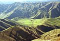
Joseph Canyon as seen from Fields Spring State Park


See also
 In Spanish: Condado de Asotin para niños
