
Athabasca Glacier facts for kids
Quick facts for kids Athabasca Glacier |
|
|---|---|

Athabasca Glacier in July 2020
|
|

Location in Alberta
|
|
| Coordinates | 52°11′55″N 117°14′37″W / 52.19861°N 117.24361°W |
| Area | 6 km2 (2.3 sq mi) |
| Length | 6 km (3.7 mi) |
| Thickness | 90–300 metres (300–980 ft) |
| Status | Receding |
The Athabasca Glacier is one of the six principal 'toes' of the Columbia Icefield, located in the Canadian Rockies. The glacier currently loses depth at a rate of about 5 metres (16 ft) per year and has receded more than 1.5 km (0.93 mi) and lost over half of its volume in the past 125 years. Easily accessible, it is the most visited glacier in North America. The leading edge of the glacier is within easy walking distance; however, travel onto the glacier is not recommended unless properly equipped. Hidden crevasses have led to the deaths of unprepared tourists.
The Icefield Interpretive Centre, closed during the winter (mid-October to mid-April), stands across from the glacier. It is used as a lodge and for ticket sales for sightseeing on the glacier. Standard buses transport tourists to the glacier edge, where they board specially designed snow coaches for transport over the steep grades, snow and ice part way up the glacier.
The glacier is approximately 6 km (3.7 mi) long, covers an area of 6 km2 (2.3 sq mi), and is measured to be between 90–300 metres (300–980 ft) thick.
Gallery
-
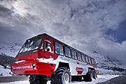
Athabasca Glacier snow coach in 2009
-
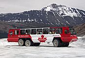
Terra Bus on the Athabasca Glacier in 2010
-
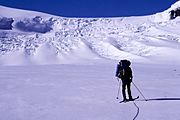
Approaching Athabasca Glacier Headwall
-
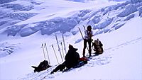
Athabasca Glacier headwall (on the ramp)


See also
 In Spanish: Glaciar Athabasca para niños
