
Atlanta metropolitan area facts for kids
Quick facts for kids
Metro Atlanta
Atlanta metropolitan area
|
|
|---|---|

Map of Metro Atlanta
|
|
| Country | United States |
| State | Georgia |
| Largest city | Atlanta |
| Area | |
| • Metro | 8,376 sq mi (21,694 km2) |
| • CSA | 10,494.03 sq mi (27,179.4 km2) |
| Elevation | 606 - 3,288 ft (185 - 1,002 m) |
| Population
(2012 Estimates)
|
|
| • Density | 630/sq mi (243/km2) |
| • Urban | 4,515,419 (9th) |
| • MSA | 5,457,831 (9th) |
| • CSA | 6,092,295 (11th) |
| Time zone | UTC-5 (EST) |
| • Summer (DST) | UTC-4 (EDT) |
| ZIP codes |
300xx to 303xx
|
| Area code(s) | 404, 770, 678, 470 |
The Atlanta metropolitan area is an area around the city of Atlanta. The United States Office of Management and Budget calls the area the "Atlanta-Sandy Springs-Roswell, GA Metropolitan Statistical Area". It is also unofficially known as Metro Atlanta. More people live in the Atlanta metropolitan area than any other metro area in Georgia. It is the ninth largest metro area in the United States. The Atlanta metropolitan area includes 29 counties in north Georgia. The US Census Bureau estimated that 5,457,831 people lived in the Atlanta metropolitan area in 2012.
Images for kids
-
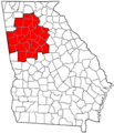
Location in Georgia (MSA counties in red)
-
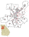
Atlanta suburbs and surrounding cities map. Note that the newly incorporated cities of Brookhaven, Peachtree Corners, Tucker, Stonecrest and South Fulton are not yet shown as incorporated (gray) on the map.


See also
 In Spanish: Área metropolitana de Atlanta para niños
