Audrain County, Missouri facts for kids
Quick facts for kids
Audrain County
|
|
|---|---|

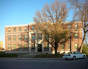
The Audrain County Courthouse in Mexico
|
|

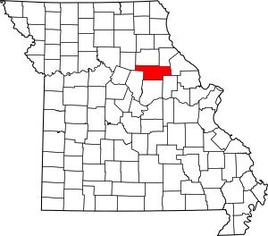
Location within the U.S. state of Missouri
|
|
 Missouri's location within the U.S. |
|
| Country | |
| State | |
| Founded | December 17, 1836 |
| Named for | James Hunter Audrain |
| Seat | Mexico |
| Largest city | Mexico |
| Area | |
| • Total | 697 sq mi (1,810 km2) |
| • Land | 692 sq mi (1,790 km2) |
| • Water | 4.6 sq mi (12 km2) 0.7% |
| Population
(2020)
|
|
| • Total | 24,962 |
| • Density | 35.813/sq mi (13.828/km2) |
| Time zone | UTC−6 (Central) |
| • Summer (DST) | UTC−5 (CDT) |
| Congressional districts | 4th, 6th |
Audrain County is a county located in the central part of the U.S. state of Missouri. As of 2020, the population was 24,962. Its county seat is Mexico. The county was organized December 13, 1836, and named for Colonel James Hunter Audrain of the War of 1812 and who later was elected to the state legislature.
Contents
History
Audrain County was one of several along the Missouri River settled by migrants from the Upper South, especially Kentucky and Tennessee. They brought slaves and slaveholding traditions with them, and quickly started cultivating crops similar to those in Middle Tennessee and Kentucky: hemp and tobacco. They also brought characteristic antebellum architecture and culture. The county was considered at the heart of what was called Little Dixie.
Geography
According to the U.S. Census Bureau, the county has a total area of 697 square miles (1,810 km2), of which 692 square miles (1,790 km2) is land and 4.6 square miles (12 km2) (0.7%) is water.
Adjacent counties
- Monroe County (north)
- Ralls County (northeast)
- Pike County (east)
- Montgomery County (southeast)
- Callaway County (south)
- Boone County (southwest)
- Randolph County (northwest)
Major highways
Demographics
| Historical population | |||
|---|---|---|---|
| Census | Pop. | %± | |
| 1840 | 1,949 | — | |
| 1850 | 3,506 | 79.9% | |
| 1860 | 8,075 | 130.3% | |
| 1870 | 12,307 | 52.4% | |
| 1880 | 19,732 | 60.3% | |
| 1890 | 22,074 | 11.9% | |
| 1900 | 21,160 | −4.1% | |
| 1910 | 21,687 | 2.5% | |
| 1920 | 20,589 | −5.1% | |
| 1930 | 22,077 | 7.2% | |
| 1940 | 22,673 | 2.7% | |
| 1950 | 23,829 | 5.1% | |
| 1960 | 26,079 | 9.4% | |
| 1970 | 25,362 | −2.7% | |
| 1980 | 26,458 | 4.3% | |
| 1990 | 23,599 | −10.8% | |
| 2000 | 25,853 | 9.6% | |
| 2010 | 25,529 | −1.3% | |
| 2020 | 24,962 | −2.2% | |
| U.S. Decennial Census 1790-1960 1900-1990 1990-2000 2010-2015 |
|||
Audrain County comprises the Mexico, MO Micropolitan Statistical Area, which is included in the Columbia-Moberly-Mexico, MO Combined Statistical Area.
At the time of the 2010 United States Census, there were 25,529 people, 9,844 households, and 6,762 families residing in the county. The population density was 37 people per square mile (14/km2). There were 10,881 housing units at an average density of 16 per square mile (6/km2). 89.8% of the population were White, 6.4% Black or African American, 0.5% Asian, 0.4% Native American, 1.2% of some other race and 1.7% of two or more races. 2.6% were Hispanic or Latino (of any race). 33.2% were of German, 16.0% American, 9.3% Irish and 8.4% English ancestry.
There were 9,844 households, out of which 31.40% had children under the age of 18 living with them, 55.20% were married couples living together, 9.90% had a female householder with no husband present, and 31.30% were non-families. 27.80% of all households were made up of individuals, and 13.40% had someone living alone who was 65 years of age or older. The average household size was 2.43 and the average family size was 2.96.
In the county, the population was spread out, with 24.60% under the age of 18, 7.90% from 18 to 24, 28.20% from 25 to 44, 22.50% from 45 to 64, and 16.90% who were 65 years of age or older. The median age was 38 years. For every 100 females there were 84.20 males. For every 100 females age 18 and over, there were 78.70 males.
The median income for a household in the county was $32,057, and the median income for a family was $40,448. Males had a median income of $28,550 versus $20,712 for females. The per capita income for the county was $16,441. About 11.10% of families and 14.80% of the population were below the poverty line, including 23.30% of those under age 18 and 9.80% of those age 65 or over.
Religion
According to the Association of Religion Data Archives County Membership Report (2010), Audrain County is sometimes regarded as being on the northern edge of the Bible Belt, with evangelical Protestantism being the most predominant religion. The most predominant denominations among residents in Audrain County who adhere to a religion are Southern Baptists (36.07%), Roman Catholics (12.55%), and Christian Churches and Churches of Christ (8.09%).
Communities
Cities
Villages
Unincorporated communities
Townships
Audrain County is divided into eight townships:
|
|
Education
Public schools
-
- Community Elementary School (PK-05)
- Community High School (06-12)
- McMillan Early Learning Center (PK-K)
- Hawthorne Elementary School (K-05)
- Eugene Field Elementary School (K-05)
- Mexico Middle School (06-08)
- Mexico High School (09-12)
- Van-Far Elementary School (PK-06)
- Van-Far High School (07-12)
Private schools
- Sunnydale Seventh-day Adventist Elementary School – Centralia (02-09) – Seventh-day Adventist
Public libraries
- Mexico-Audrain County Library District
Notable people
- Tom Bass, horse trainer
- Cookie Belcher, former professional basketball player
- Howard L. Bickley, Chief Justice of New Mexico
- Kit Bond - U.S. Senator (R-Missouri) (1987-2011) and Governor of Missouri (1973-1977 & 1981–1985)
- Jason Brookins, former NFL running back with the Baltimore Ravens
- Pendleton Dudley, journalist and public relations
- Charles Henry Hardin - Governor of Missouri (1875-1877) and co-founder of Beta Theta Pi fraternity
- Anna J. Harrison - First female president of the American Chemical Society
- Edward D. "Ted" Jones, broker
- Howard Kindig, former Super Bowl winning NFL player
- Tyronn Lue, head coach of the Los Angeles Clippers and former NBA player
- Adolph John Paschang, Roman Catholic bishop
- Prim Siripipat, television anchor
- Lebbeus R. Wilfley, federal judge
- Xenophon P. Wilfley, U.S. Senator (D-Missouri) (1918-1918)
See also
 In Spanish: Condado de Audrain para niños

