
Ayent facts for kids
Quick facts for kids
Ayent
|
||
|---|---|---|
|
||
| Country | Switzerland | |
| Canton | Valais | |
| District | Hérens | |
| Area | ||
| • Total | 55.26 km2 (21.34 sq mi) | |
| Elevation | 967 m (3,173 ft) | |
| Highest elevation
(Wildhorn)
|
3,247 m (10,653 ft) | |
| Lowest elevation
(hameau de la Maya)
|
508 m (1,667 ft) | |
| Population
(Dec 2020 )
|
||
| • Total | 4,137 | |
| • Density | 74.864/km2 (193.90/sq mi) | |
| Postal code |
1966
|
|
| Localities | Botyre, Luc, Saxonne, La Place, Blignou, Fortunoz, Saint-Romain, Signèse, Villa, Argnou, Anzère | |
| Surrounded by | Arbaz, Grimisuat, Icogne, Lauenen (BE), Lenk im Simmental (BE), Saint-Léonard, Savièse, Sion | |
| Twin towns | Saint-Brévin-les-Pins (France) | |

Ayent is a municipality of the district Hérens in the canton of Valais in Switzerland.

Images for kids
-
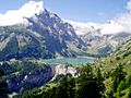
Lac de Tseuzier
-
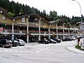
Anzere downtown
-
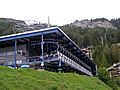
Cable car at Anzere


See also
 In Spanish: Ayent para niños

All content from Kiddle encyclopedia articles (including the article images and facts) can be freely used under Attribution-ShareAlike license, unless stated otherwise. Cite this article:
Ayent Facts for Kids. Kiddle Encyclopedia.