Badgebup, Western Australia facts for kids
Quick facts for kids BadgebupWestern Australia |
|
|---|---|

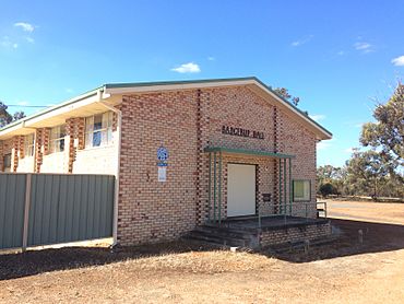
Badgebup Hall 2018
|
|
| Population | 37 (2016 census) |
| Established | 1923 |
| Postcode(s) | 6317 |
| Elevation | 306 m (1,004 ft) |
| Location |
|
| LGA(s) | Shire of Katanning |
| State electorate(s) | Roe |
| Federal Division(s) | O'Connor |
Badgebup is a small community in the Great Southern region of Western Australia. The town is located between the towns of Katanning and Nyabing. The Badgebup Reserve, north of the town, forms part of the Kwobrup-Badgebup Important Bird Area.
Name
The name originates from the nearby Badgebup Well. Badgebup is an Aboriginal word which is thought to mean either "place of the wild rushes" or "broad green leaves on a plant round soak". It was initially suggested that the area would be named "Badjebupp" after the name of the station on the Katanning to Nyabing railway line. The town was gazetted as Badjebup in 1923 then changed to Nalabup, and back to Badjebup in the same year then finally to Badgebup in 1972.
History
A bushfire swept through the area in 2004 destroying crops, sheds and homes in 2004. Volunteer firefighters eventually contained the blaze but not before two homes and three sheds, one containing several vintage cars were lost.
The main industry in town is wheat farming with the town being a Cooperative Bulk Handling receival site.


