
Bakersfield, California facts for kids
Quick facts for kids
Bakersfield, California
|
|||
|---|---|---|---|
| City of Bakersfield | |||
.jpg) _(cropped).jpg) .jpg)  .jpg) .JPG) Top: Fox Theater, Padre Hotel; Middle: Beale Memorial Clock Tower, Bakersfield Californian Building, Kern County Museum; Bottom: aerial view of central Bakersfield
|
|||
|
|||
| Nickname(s):
"Nashville West"
|
|||

Location of Bakersfield in Kern County, California
|
|||

Bakersfield, California
Location in California

Bakersfield, California
Location in the United States

Bakersfield, California
Location in North America
|
|||
| Country | United States | ||
| State | California | ||
| County | Kern | ||
| Region | San Joaquin Valley | ||
| Incorporated | 1873–1876 | ||
| Re-incorporated | January 11, 1898 | ||
| Named for | Thomas Baker | ||
| Government | |||
| • Type | Council-Manager | ||
| • Body | Bakersfield City Council | ||
| Area | |||
| • City | 151.28 sq mi (391.80 km2) | ||
| • Land | 149.81 sq mi (388.01 km2) | ||
| • Water | 1.46 sq mi (3.79 km2) | ||
| Elevation | 404 ft (123 m) | ||
| Population
(2020)
|
|||
| • City | 403,455 | ||
| • Rank | 48th in the United States 9th in California |
||
| • Density | 2,693.09/sq mi (1,039.81/km2) | ||
| • Metro | 909,235 (62nd) | ||
| Demonym(s) | Bakersfieldian | ||
| Time zone | UTC−8 (Pacific) | ||
| • Summer (DST) | UTC−7 (PDT) | ||
| ZIP codes |
93220, 93301–93309, 93311–93314, 93380–93390, 93399
|
||
| Area code | 661 | ||
| FIPS code | 06-03526 | ||
| GNIS feature IDs | 1652668, 2409774 | ||


Bakersfield is a city in Kern County, California, United States. It is the county seat and largest city of Kern County. The city covers about 151 sq mi (390 km2) near the southern end of the San Joaquin Valley and the Central Valley region. Bakersfield's population as of the 2020 census was 403,455, making it the 48th-most populous city in the United States of America and the 9th-most populous city in California. The Bakersfield–Delano Metropolitan Statistical Area, which includes all of Kern County, had a 2020 census population of 909,235, making it the 62nd-largest metropolitan area in the United States. The more built-up portion of the metro area that includes Bakersfield and areas immediately around the city, such as East Bakersfield, Oildale, and Rosedale, has a population of 523,994.
Bakersfield is a significant hub for both agriculture and energy production. Kern County is the most productive oil-producing county in California and the fourth-most productive agricultural county (by value) in the United States. Industries in and around Bakersfield include natural gas and other energy extraction, mining, petroleum refining, distribution, food processing, and corporate regional offices. The city is the birthplace of the country music genre known as the Bakersfield sound.
Contents
History
Archaeological evidence indicates the presence of Native American settlements dating back thousands of years. The Yokuts lived in lodges along the branches of the Kern River Delta and hunted antelope, tule elk, deer, bear, fish, and game birds. In 1776, Spanish missionary Father Francisco Garcés became the first European to explore the area. Owing to the remoteness and inaccessibility of the region, however, the Yokuts remained largely isolated until after the Mexican War of Independence, when Mexican settlers began to migrate to the area. Following the discovery of gold in California in 1848, settlers flooded into the San Joaquin Valley. In 1851, gold was discovered along the Kern River in the southern Sierra Nevada, and in 1865, oil was discovered in the valley. The Bakersfield area, once a tule-reed-covered marshland, was first known as Kern Island to the handful of pioneers who built log cabins there in 1860. The area was subject to periodic flooding from the Kern River, which occupied what is now the downtown area, and experienced outbreaks of malaria.
Founding
In 1862, disastrous floods swept away the original settlement founded in 1860 by the German-born Christian Bohna. Among those attracted to the area by the California gold rush was Thomas Baker, a lawyer and former colonel in the militia of Ohio, his home state. Baker moved to the banks of the Kern River in 1863, at what became known as Baker's Field, which became a stopover for travelers. By 1870, with a population of 600, what is now known as Bakersfield was becoming the principal town in Kern County.
In 1873, Bakersfield was officially incorporated as a city, and by 1874 it officially replaced the dying town of Havilah as the county seat. Alexander Mills was hired as the city marshal, a man one historian would describe as "... an old man by the time he became Marshal of Bakersfield, and he walked with a cane. But he was a Kentuckian, a handy man with a gun, and not lacking in initiative and resource when the mood moved him." Businessmen and others began to resent Mills, who was cantankerous and high-handed in his treatment of them. Wanting to fire him but fearing reprisals, they came up with a scheme to disincorporate, effectively leaving him without an employer. According to local historian Gilbert Gia, the city was also failing to collect the taxes it needed for services. In 1876, the city voted to disincorporate. For the next 22 years, a citizen's council managed the community.
By 1880, the town had a population of 801, and by 1890, it had a population of 2,626. Migration from Texas, Louisiana, Oklahoma, and Southern California brought new residents, who were mostly employed by the oil industry.
The city reincorporated on January 11, 1898.
1952 earthquake

On July 21, 1952, an earthquake struck at 4:52 am Pacific Daylight Time. The earthquake, which measured 7.5 on the moment magnitude scale and was felt from San Francisco to the Mexican border, destroyed the nearby communities of Tehachapi and Arvin. The earthquake's destructive force also bent cotton fields into U shapes, slid a shoulder of the Tehachapi Mountains across all four lanes of the Ridge Route, collapsed a water tower creating a flash flood, and destroyed the railroad tunnels in the mountain chain. Bakersfield was spared, experiencing minor architectural damage without loss of life.
A large aftershock occurred on July 29, and did minor architectural damage, but raised fears that the flow of the Friant-Kern Canal could be dangerously altered, potentially flooding the city and surrounding areas.
Aftershocks, for the next month, had become normal to Bakersfield residents, until August 22 at 3:42 pm a 5.8 earthquake struck directly under the town's center in the most densely populated area of the southern San Joaquin Valley. Four people died in the aftershock, and many of the town's historic structures were permanently lost.
20th and 21st centuries
Between 1970 and 2010, Bakersfield grew 400% (from 70,000 to 347,483), making it one of the fastest growing cities in California.
Bakersfield's close proximity to mountain passes, primarily the Tejon Pass on Interstate 5 between the Los Angeles metropolis and the central San Joaquin Valley, has made the city a regional transportation hub.
In 1990, Bakersfield was one of ten U.S. communities to receive the All-America City Award from the National Civic League.
In 2010, the Bakersfield MSA had a gross metropolitan product of $29.466 billion, making it the 73rd largest metropolitan economy in the United States.
Geography

Bakersfield lies near the southern "horseshoe" end of the San Joaquin Valley, with the southern tip of the Sierra Nevada just to the east. The city limits extend to the Sequoia National Forest, at the foot of the Greenhorn Mountain Range and at the entrance to the Kern Canyon. To the south, the Tehachapi Mountains feature the historic Tejon Ranch. To the west is the Temblor Range, behind which is the Carrizo Plain National Monument and the San Andreas Fault. The Temblor Range is about 35 mi (56 km) from Bakersfield across the valley floor.
According to the United States Census Bureau, the city has a total area of 143.6 sq mi (372 km2), of which 142.2 sq mi (368 km2) is land (98.99%) and 1.4 sq mi (3.6 km2) is covered by water (1.01%).
At the 2000 census, the city had a total area of 114.4 sq mi (296 km2), of which 113.1 sq mi (293 km2) was land (98.86%) and 1.3 sq mi (3.4 km2) was water-covered (1.14%).
Bakersfield lies around 100 miles (160 km) north of Los Angeles (about a 1½-hour drive on I-5 and State Route 99) and about 300 mi (480 km) southeast of the state capital, Sacramento (about a 4½-hour drive on State Route 99).
Communities and neighborhoods
Bakersfield has historically referred to its regions by directional names. They include: North Bakersfield, Northeast, Southeast, South Bakersfield, Southwest, and Northwest. East Bakersfield generally refers to the former town of Sumner (later renamed East Bakersfield). As a result, the Northeast wraps around East Bakersfield.
Climate

Although the region hosts abundant green and leafy vegetation due to the hydrology of the Tulare Basin, Bakersfield has a desert climate (Köppen BWh), with long, hot, dry summers, and brief, cool, moist (but not wet) winters. In fact, Bakersfield enjoys more clear days than the majority of the U.S. (averaging 191 days a year). Bakersfield enjoys long-lasting, mild autumns, and warm springs, giving the region a unique climate suitable for growing a wide variety of crops (ranging from carrots to citrus, almonds, and pistachios). Rainfall averages only 6.5 in (165 mm) annually, mostly falling during winter and spring. Typically, no rain falls from May through September.
Summers have extended stretches of hot weather, with 108 days per year above 90 °F (32 °C) (on average between April 19 and October 12); in addition, 33 days are above 100 °F (38 °C) from late May to mid-September, and a 110 °F day can occur every few years. Winters feature mild daytime temperatures, but frost can be occasionally seen, often coming with dense tule fog and low visibility, causing many schools to have fog delays as long as three hours. The official time frame for tule fog to form is from November 1 to March 31. There are 12 nights with freezing lows (on average between December 13 and January 26) annually, and the coldest night of the year will typically bottom out below 30 °F (−1 °C).
Snow is rare on the valley floor; but it does snow in Bakersfield about once every 20 to 30 years. The last time it snowed was on January 25, 1999, when the city received 6 in (15 cm). The record maximum temperature was 118 °F (48 °C) on July 28, 1908, and the record minimum temperature was 11 °F (−12 °C) on January 3, 1908. The most rainfall in one month was 5.82 inches (148 mm) in December 2010, and the maximum 24-hour rainfall was 2.29 in (58 mm) on February 9, 1978.
| Climate data for Bakersfield, California (1981–2010 normals) | |||||||||||||
|---|---|---|---|---|---|---|---|---|---|---|---|---|---|
| Month | Jan | Feb | Mar | Apr | May | Jun | Jul | Aug | Sep | Oct | Nov | Dec | Year |
| Record high °F (°C) | 82 (28) |
88 (31) |
94 (34) |
101 (38) |
110 (43) |
114 (46) |
118 (48) |
117 (47) |
112 (44) |
104 (40) |
95 (35) |
87 (31) |
118 (48) |
| Average high °F (°C) | 56.2 (13.4) |
62.8 (17.1) |
68.7 (20.4) |
75.0 (23.9) |
83.5 (28.6) |
90.9 (32.7) |
97.1 (36.2) |
95.8 (35.4) |
90.0 (32.2) |
79.4 (26.3) |
65.7 (18.7) |
56.6 (13.7) |
76.8 (24.9) |
| Average low °F (°C) | 39.3 (4.1) |
42.4 (5.8) |
46.5 (8.1) |
50.2 (10.1) |
57.5 (14.2) |
64.2 (17.9) |
70.5 (21.4) |
69.0 (20.6) |
64.0 (17.8) |
55.0 (12.8) |
44.6 (7.0) |
39.0 (3.9) |
53.5 (11.9) |
| Record low °F (°C) | 12 (−11) |
20 (−7) |
20 (−7) |
28 (−2) |
34 (1) |
38 (3) |
45 (7) |
44 (7) |
30 (−1) |
29 (−2) |
22 (−6) |
13 (−11) |
12 (−11) |
| Average precipitation inches (mm) | 1.15 (29) |
1.23 (31) |
1.21 (31) |
.52 (13) |
.18 (4.6) |
.08 (2.0) |
0 (0) |
.04 (1.0) |
.08 (2.0) |
.30 (7.6) |
.64 (16) |
1.02 (26) |
6.45 (163.2) |
| Average precipitation days (≥ 0.01 in) | 6.7 | 7.1 | 6.5 | 3.7 | 1.7 | .5 | .1 | .3 | 1.0 | 1.8 | 3.9 | 5.9 | 39.2 |
| Source: NOAA (extremes 1893–present) | |||||||||||||
Air quality problems
In 2015, The American Lung Association ranked Bakersfield as the second-most polluted city in the United States in terms of both short-term and year-round particle pollution. It also ranked Bakersfield third as the most ozone-polluted city in the United States. In Peter Greenberg's book Don't Go There!, Bakersfield is mentioned for its high ozone levels, and postulates that its rapid increase in size is causing the increasing rate of pollution from new construction.
As of 2013, when measured by atmospheric particulate matter—specifically PM10, particles of 10 µm or less—Bakersfield is listed as having the worst air in the United States.
Demographics
| Historical population | |||
|---|---|---|---|
| Census | Pop. | %± | |
| 1880 | 801 | — | |
| 1890 | 2,626 | 227.8% | |
| 1900 | 4,836 | 84.2% | |
| 1910 | 12,727 | 163.2% | |
| 1920 | 18,638 | 46.4% | |
| 1930 | 26,015 | 39.6% | |
| 1940 | 29,252 | 12.4% | |
| 1950 | 34,784 | 18.9% | |
| 1960 | 56,848 | 63.4% | |
| 1970 | 69,515 | 22.3% | |
| 1980 | 105,611 | 51.9% | |
| 1990 | 174,820 | 65.5% | |
| 2000 | 247,057 | 41.3% | |
| 2010 | 347,483 | 40.6% | |
| 2020 | 403,455 | 16.1% | |
| U.S. Decennial Census | |||
| Ethnic composition | 2020 | 2010 | 1990 | 1970 | 1940 |
|---|---|---|---|---|---|
| White | 38.9% | 56.8% | 72.7% | 83.6% | 94.6% |
| —Non-Hispanic | 28.8% | 37.8% | 65.9% | 70.8% | n/a |
| Black or African American | 7.0% | 8.1% | 9.4% | 13.3% | 3.5% |
| Hispanic or Latino (of any race) | 52.7% | 45.5% | 20.5% | 10.9% | n/a |
| Asian | 7.8% | 6.2% | 3.6% | 1.1% | − |
| Two or more Races | 16.6% | 4.9% | n/a | n/a | n/a |
.png)
2010
The 2010 United States Census reported that Bakersfield had a population of 347,483. The population density was 2,419.6 people per square mile (934.2/km2). The ethnic makeup of Bakersfield was 197,389 (56.8%) White, 28,238 (8.1%) African American, 5,102 (1.5%) Native American, 21,432 (6.2%) Asian (2.1% Indian, 2.0% Filipino, 0.5% Chinese, 0.4% Korean, 0.2% Japanese, 478 (0.1%) Pacific Islander), 77,686 (22.4%) from other races, and 17,068 (4.9%) from two or more races. Hispanics or Latinos of any race were 158,205 persons (45.5%). Among the general population, 39.5% are Mexican, 1.3% Salvadoran, 0.5% Guatemalan, and 0.10% Colombian. Non-Hispanic Whites were 37.8% of the population in 2010, compared to 71% in 1980.
The census reported 344,088 people (99.0% of the population) lived in households, 2,094 (0.6%) lived in noninstitutionalized group quarters, and 1,301 (0.4%) were institutionalized.
Of the 111,132 households, 51,995 (46.8%) had children under the age of 18 living in them, 57,276 (51.5%) were opposite-sex married couples living together, 18,049 (16.2%) had a female householder with no husband present, and 7,829 (7.0%) had a male householder with no wife present. There were 8,159 (7.3%) unmarried opposite-sex partnerships, and 845 (0.8%) same-sex married couples or partnerships. About 21,800 households (19.6%) were made up of individuals, and 7,354 (6.6%) had someone living alone who was 65 years of age or older. The average household size was 3.10. There were 83,154 families (74.8% of all households); the average family size was 3.56.
The population was distributed as 109,479 people (31.5%) under the age of 18, 37,368 (10.8%) aged 18 to 24, 97,024 (27.9%) aged 25 to 44, 74,276 (21.4%) aged 45 to 64, and 29,336 (8.4%) who were 65 years of age or older. The median age was 30.0 years. For every 100 females, there were 96.0 males. For every 100 females age 18 and over, there were 92.5 males.
The 120,725 housing units averaged 840.6 per square mile (324.6/km2), of which 66,323 (59.7%) were owner-occupied, and 44,809 (40.3%) were occupied by renters. The homeowner vacancy rate was 3.2%; the rental vacancy rate was 9.0%. About 206,492 people (59.4% of the population) lived in owner-occupied housing units, and 137,596 people (39.6%) lived in rental housing units.
Bakersfield has consistently ranked as one of the least educated metropolitan areas in the United States. A study by the Brookings Institution using 2008 data found that the proportion of Bakersfield metro adults age 25 and over with a bachelor's degree was the lowest (14.7%) of the 100 largest metropolitan areas in the United States; that 100th-place finish was down from being ranked 95th in 1990.
According to a Gallup-Healthways Well-Being Index, Bakersfield ranks as one of the ten most obese metro areas in America. Of its residents, 33.6% were found to be obese, compared to the national average of 26.5%. The same study found that 21.2% were smokers, 12.7% had diabetes, 27.9% had high blood pressure, 22.8% had high cholesterol, 3.3% had had a heart attack, 75.2% felt they had enough money to buy food and 75.5% had health insurance.
Housing and development
Bakersfield saw its population grow from about 105,000 in 1980 to 347,000 in 2010. Although the city is still growing, its growth rate has slowed in recent years due to the economic recession and high home foreclosure rates. However, in October 2013, Bakersfield was found to be the number two city in the nation for the rental market. Apartment vacancies have become a large issue with only one percent of potential apartments being open to new renters as of April 2021. The average cost of rent and housing have dramatically increased in the last few years, with some apartments having their monthly rent nearly double in cost. Most new apartments being built are catering to commuting workers from Southern California and the Bay Area, with local residents being priced out.
The city of Shafter, a small farming town north of Bakersfield, previously filed a suit to attempt to limit the northern expansion of Bakersfield's city limits. Shafter has also annexed large pieces of farmland to its east and south to ensure that Bakersfield does not annex this area. Bakersfield, in addition, filed a lawsuit against Shafter in 2007 regarding water rights Shafter planned to use but Bakersfield stated it had purchased in 1976. As a result, the city of Bakersfield threatened to annex the city of Shafter.
The large bluff and plateau which lie east of Bakersfield—toward the Rio Bravo and Kern Canyon area—have been under development for the last 60 years. Because the steep, north-facing edge of the bluff provides a view of the foothills, mountains, oil fields, and Kern River, the city government has attempted to balance development and preservation in this area.
Arts and culture
Many of Bakersfield's oldest and most historic restaurants are Basque, including Woolgrowers, Noriega's, Pyrenees, Benji's, and Narducci's.
The Kern County Museum, located on Chester Avenue just north of downtown Bakersfield holds a collection of regional artifacts. Permanent exhibits include: "Black Gold: The Oil Experience", a hands-on modern approach at showing how oil is extracted; and "The Lori Brock Children's Discovery Museum", a hands-on children's museum and a display on the influential "Bakersfield Sound" style of country music. Bakersfield is also home to the Buena Vista Museum of Natural History, which has a collection of Miocene era marine fossils collected from the region as well as other displays.
The city gained fame in the late 1950s and early 1960s for the Bakersfield Sound, an electric guitar-driven subgenre of country music that commercially dominated the industry for more than a decade. Buck Owens and Merle Haggard were its best-known stars.
Events
Bakersfield hosts horse shows all year round, including local, 4H, and breed shows.
Every spring, Bakersfield hosts one of California's Scottish Games and Clan Gatherings. In the late summer, St. George's Greek Orthodox Church hosts an annual Greek Festival.
Every year during the summer, Bakersfield hosts the Lowrider National at the Kern County Fairgrounds.
Memorial Day weekend features the Kern County Basque Festival, sponsored by the Kern County Basque Club. This three-day festival features food, music, dance, and handball games.
In March, Famoso Raceway holds the annual March Meet nostalgia drag racing event. The event dates back to the U.S. Fuel and Gas Finals held in March 1959.
Twice a year, the CSUB Indigenous Native American Club hosts a Native Gathering on the California State University Bakersfield campus at Runner Park.
Native American Preservation Council of Kern County have hosted an annual intertribal pow wow every June since the 1990s.
In mid to late September, Bakersfield holds the annual Kern County Fair, which showcases the area's agricultural produce and animal husbandry, along with a rodeo, concerts, and a traditional carnival.
Previously every year and now every five years, Bakersfield hosts a political conference known as the Bakersfield Business Conference. Since 1985, this conference has grown in attendance and as of 2007 the attendance numbered over 9,000. The Conference has had several notable political speakers to include Ronald Reagan, Jimmy Carter, Gerald Ford, George Bush, Margaret Thatcher, Neil Armstrong, Norman Schwarzkopf, Colin Powell, Mike Wallace, Dan Rather, Tom Brokaw, Rush Limbaugh, Sarah Palin, and Paul Harvey.
Entertainment

Bakersfield has five movie multi-screen theaters: Edwards Bakersfield Stadium 14, Reading Cinemas Valley Plaza 16, Maya Cinemas Bakersfield 16, and Regency Theatres East Hills 10. There is also a second-run theater; Starplex Cinemas 6. The historic downtown Fox Theater (Bakersfield, California) has been renovated, and is now a venue for concerts, musicians, comedians, and movies.
Music
Classical
The Bakersfield Symphony Orchestra has been performing for over 80 years.
Country
Bakersfield is known for the Bakersfield sound, "a twangy style of Fender Telecaster and pedal steel guitar music made popular by hometown country crooners Buck Owens and Merle Haggard."
Doowop
Bakersfield is also known for Doowop music dating back from the early-to-mid 1950s' to the early-to-late 1960s'. Which consist of Doowop vocal groups such as: The Paradons, The Colts, The Rev-Lons, and more.
Rock
In 1972, Bob Weir released the song "Mexicali Blues" on his first solo album, Ace. Not only does the sound of the song pay tribute to the Bakersfield sound, but the name of the city is referenced in the lyrics.
In 1978, The Rolling Stones released the song "Far Away Eyes" on the album Some Girls. Mick Jagger and Keith Richards collaborated extensively on writing the song and it was recorded in late 1977. The Rolling Stones, longtime country music fans, incorporated many aspects of "Bakersfield sound" country music into this song. Bakersfield is mentioned in the first line of the song.
In the early 1990s, a group of friends from the lower and middle-class parts of Northeast and East Bakersfield formed the alternative metal band KoRn. The members of the band attended Highland High School (Jonathan Davis and Reginald "Fieldy" Arvizu), East High School (James "Munky" Shaffer and lead guitarist Brian "Head" Welch) and South High School (David Silveria). Korn have sold over 40 million albums worldwide and were given the keys to the city.
Orange County punk band Social Distortion have a song on their 2011 album Hard Times and Nursery Rhymes entitled "Bakersfield."
San Jose, California pop punk band Four O'clock Heroes have a song on their 2012 album "Take Control" named "Bakersfield."
Bakersfield, California americana band Lonely Avenue tribute their home town with the track "Bakersfield" on their 2016 self-titled album.
Websites
There are several websites that cover Bakersfield and what happens in and around the city. The most notable of these are The Bakersfield Californian and Bakersfield Magazine websites.
OHV Park
Bakersfield is home to a large population of off-highway vehicle (OHV) enthusiasts. As of May 2001, over 18,000 OHVs were registered in Kern County. On May 26, 2005, the City of Bakersfield and the State of California Parks department obtained an assignable option, using a grant from the OHV Trust funds, to purchase a prospective 11,000 acres (45 km2) site for an OHV park. Ruth Coleman, Director of California State Parks, remarked, "This project responds to the needs of the Bakersfield community for increased recreation opportunities and will provide a cornerstone for the Central Valley Strategy." Several programs, including National 4-H and California Off-Road PALS, exist to train youth in proper OHV recreation.
Transportation
Highways


Bakersfield is serviced by an extensive highway network which includes three freeways. State Route 99 bisects Bakersfield from north to south, while State Route 58 exists as a freeway east of SR 99, servicing the southeast part of the city and extending over the Tehachapi mountains to Tehachapi, Mojave, and Barstow. State Route 178 consists of a short segment of freeway that runs from a point near downtown to the northeastern part of the city, although there is currently no direct freeway connection between SR 99 and SR 178. Interstate 5 bypasses the city several miles to the west.
Bakersfield is also served by a short, unsigned, four-lane freeway called Alfred Harrell Highway. It was constructed between 1956 and 1958 and extends from China Grade Loop to Hart Park (a large recreation park in northeast Bakersfield). There is also a two-lane expressway to the east of the park. This section was originally reserved to be converted to a four-lane freeway similar to the constructed western portion. If it were ever constructed, it would have two interchanges (at Morning Drive and Lake Ming Road) and would terminate at the SR 178 adopted alignment (not constructed).
Both SR 58 and SR 178 have planned future extensions. The western extension of SR 58 is known as the Centennial Corridor, which will extend the freeway west to I-5. Included in the Centennial Corridor is the Westside Parkway (sometimes referred to by its formal name, the Kern River Freeway). This is a newer freeway which runs through western Bakersfield, on a route parallel to the Kern River and Stockdale Highway. The western extension of SR 178 is known as the Crosstown Freeway/SR 178 Connection, although it was formerly known as the Centennial Corridor before that name was moved to SR 58. It is planned to connect SR 178 to the Westside Parkway.
In addition to these freeway extensions, there is also a proposed network of beltways. Currently, there are two beltways being considered in Bakersfield. The West Beltway would run north–south from Seventh Standard Road to Taft Highway. It will run parallel to Heath Road to the north and parallel to South Allen Road to the south. A future extension would connect the West Beltway to SR 99 and I-5, providing a bypass to Bakersfield. The South Beltway would run east–west from SR 58 to I-5. From SR 58, it would run south, parallel to Comanche Drive until Taft Highway. From there, the freeway would turn west, and run parallel to Taft Highway until terminating at I-5.

A future extension would extend the freeway north to SR 178 and terminate at Alfred Harrell Highway. Bakersfield also envisioned Caltrans building a North Beltway as the western extension of SR 58, but this has been withdrawn in favor of the Centennial Corridor.
Most of Bakersfield’s major streets are six-lane divided roads with bike lanes, with almost every street in the city having proper lane signage for bicycle traffic. Bikes are a popular method of transportation in Bakersfield, due to the city’s relatively flat topography and grid-like street system. Newer neighborhoods on the outskirts of the city, previously surrounded by two-lane farm roads, are prompting more large, divided roads to be built to help ease the increase in traffic that has resulted from an explosion in population. Many developers choose to widen the roads that connect these neighborhoods at their own discretion, which can cause a major road to widen and narrow repeatedly over a short distance (Allen Road and Panama Lane are prime examples of this). Since the Bakersfield city limit boundaries are not uniform and leap over different neighborhoods, this can cause Kern County “islands” to exist within Bakersfield. The county of Kern may choose not to upgrade a road while the city of Bakersfield does improve a road, which can cause traffic congestion to increase (Calloway Drive from the Westside Parkway north to Rosedale Highway best exemplifies this disparity).
Bakersfield is currently one of the largest cities in the U.S. that is not directly linked to an Interstate highway. However, SR 99 and SR 58 have been considered for conversion to Interstates. SR 99 would be a new Interstate signed either as Interstate 7 or Interstate 9, while SR 58 would be an extension of I-40 which currently terminates in Barstow. In 2005, SR 99 was added to the FHWA list of high priority corridors as "California farm to market route" and designated a Future Interstate.
Garces Memorial Traffic Circle, informally known as Garces Circle or just “the Circle”, is a traffic circle in Bakersfield. The traffic circle is located at the intersection of Chester Avenue, Golden State Avenue (State Route 204), and 30th Street. The Circle was built circa 1932 as a part of US 99. A large sculpture of Francisco Garces was erected inside the circle in 1939.
Bus
Bakersfield is served by Golden Empire Transit. Eighteen routes are operated, the majority of which serve the urbanized portion of the county which includes the city of Bakersfield. Bakersfield is also served by Kern Transit, which connects Bakersfield with other communities in Kern County. Intercity bus providers in Bakersfield include Amtrak Thruway, Greyhound, Flixbus, Orange Belt Stages, Intercalifornias, TUFESA, and Fronteras del Norte.
The privately owned Airport Valet Express used to offer daily service between Bakersfield and LAX via a connection at the Van Nuys FlyAway bus station, however, they suspended service during the 2020 pandemic and have not yet announced a reopening date.
Rail

For freight, Bakersfield is served directly by two class-1 railroads, Union Pacific, and BNSF. North of the city, each railroad uses its own rail lines; south of the city, they share a line owned by Union Pacific. The route travels over Tehachapi Pass (and through the Tehachapi Loop). There are several spur lines in and around Bakersfield. The majority are operated by the San Joaquin Valley Railroad, owned by Genesee & Wyoming.
Passenger service is provided by the San Joaquin Route, operated by Amtrak California. The Bakersfield Amtrak Station is located downtown, at the intersection of S Street and Truxtun Avenue. The city is the southern terminus of the route. There are five Amtrak Thruway Motorcoach routes, which connect passengers to destinations west, south, and east. Kern Transit also uses the station as one of its hubs, connecting passengers to regions throughout Kern County. A station for Bakersfield is planned as part of the California High-Speed Rail system, now under construction.

Airport
Meadows Field Airport in Bakersfield was recently rebuilt and dedicated as the William M. Thomas Terminal.
Also located at the Airport are the Hall Medivac Helicopter, International Flight Training Academy (a subsidiary of Japan's ANA Airlines), SRT Helicopter Flight School, and numerous other aviation mechanics and technicians. However, IFTA has suspended operations in March 2014.
Sister cities
Economy
Bakersfield's historic and primary industries have related to Kern County's two main industries, oil and agriculture. Kern County in 2013 was the most oil productive county in the US. Kern County is a part of the highly productive San Joaquin Valley, and ranks in the top five most productive agricultural counties in the nation. Major crops for Kern County include: grapes, citrus, almonds, carrots, alfalfa, cotton, and roses. The city serves as the home for both corporate and regional headquarters of companies engaged in these industries.
Bakersfield has a growing manufacturing and distribution sector. Several companies have moved to Bakersfield because of its inexpensive land, as well as proximity to international ports in both Los Angeles and Oakland. Other companies have opened regional offices and non-oil/agricultural businesses because of Bakersfield's and Kern County's business friendly policies, such as having no local utility or inventory taxes. Products manufactured in the city include: ice cream (world's largest ice cream plant), central vacuums, highway paint, and stock racing cars.
Bakersfield is the largest city to have the lowest sales tax in California at the state minimum of 7.25%.
Top employers
According to the Greater Bakersfield Chamber of Commerce, the top employers in the county based in Bakersfield are:
| # | Employer | # of Employees |
|---|---|---|
| 1 | County of Kern | 7,475 |
| 2 | The Giumarra Companies | 4,200 |
| 3 | Grimmway Farms | 3,500 |
| 4 | Bolthouse Farms | 2,000 |
| 5 | Bakersfield Memorial Hospital | 1,400 |
| 6 | City of Bakersfield | 1,300 |
| 7 | Mercy Hospitals of Bakersfield | 1,200 |
| 7 | ARB | 1,200 |
| 9 | Kern Medical Center | 1,200 |
| 10 | State Farm Insurance | 1,045 |
| 11 | Sun World | 1,025 |
| 12 | Chevron | 1,000 |
| 13 | Clinica Sierra Vista | 1,000 |
| 14 | San Joaquin Community Hospital | 880 |
| 15 | AndrewsAg | 800 |
| 16 | Sun Pacific | 800 |
| 17 | Paramount Farms | 800 |
| 18 | California State University, Bakersfield | 600 |
| 19 | Aera Energy | 600 |
| 20 | Kaiser Permanente | 500 |
Sports

Bakersfield is not represented in any of the five major sports leagues: NFL, MLB, NBA, NHL, or MLS. The closest major sports teams are in Los Angeles and they have many fans in Bakersfield. The city is home to two minor league professional sports teams: the Bakersfield Condors (American Hockey League) and the Bakersfield Train Robbers baseball club (Pecos League). It was previously home to the California League's Bakersfield Blaze baseball team which ceased operations after the 2016 season. A third minor league team, the Bakersfield Jam of the D-League (basketball), was relocated to Prescott Valley, Arizona, in 2016. The Bakersfield Magic are an expansion team in The Basketball League that will begin play in 2022.
In addition, Bakersfield has two colleges with strong athletics programs. The Bakersfield Renegades represent Bakersfield College, a community college with 19 varsity sports, the most notable being football. It competes in the Western State Conference, which is a part of the California Community College Athletic Association. The Cal State Bakersfield Roadrunners represent California State University, Bakersfield and sponsor 15 varsity sports, the most notable being basketball. It competes in NCAA Division I as a member of the Big West Conference
Bakersfield is home to Colby Lewis from the MLB team, the Texas Rangers, Stephen Neal from the Super Bowl Champions, New England Patriots. NFL players Joey Porter, David and Derek Carr also have called Bakersfield home, and still have some connection to Bakersfield.
Bakersfield is also located near a variety of motor racing venues. Current racing sports include: drag strip (at Famoso Raceway), dirt (at Bakersfield Speedway), road course (at Buttonwillow Raceway), and a paved 1/2 mile oval (at Kern County Raceway Park), which replaced Mesa Marin Raceway, a NASCAR associated oval track, that was demolished in 2004. A 1/3 mile dirt track has also opened on the Kern County Raceway Park property. The national jet boat association holds drag boat races at Lake Ming. Bakersfield is also the home town of four time Indianapolis 500 winner Rick Mears, as well as the 2007 Daytona 500 winner, and 2014 NASCAR Sprint Cup champion Kevin Harvick.
Bakersfield has many venues for a variety of different sports. One of the most notable and versatile is the Mechanics Bank Arena (formerly the Centennial Garden) which hosts concerts, shows, and sporting events. In addition, Bakersfield has facilities that can host tournament games. The Kern County Soccer Field has 24 full-size light soccer fields. Also, currently under construction is the Bakersfield Sports Village. When completed, it will have 16 baseball fields, 6 football fields, and 16 soccer fields.
Education

Two of the earliest schools founded in Kern County were Mrs. Thomas Baker's school, opened in 1863 at the Baker home (near present-day 19th and N streets); and a Catholic parochial school opened by Reverend Father Daniel Dade in 1865 in Havilah (then the county seat). In 1880, Norris School was established. The land for this school was donated by William Norris, a local farmer. Thirteen to twenty students were taught in its one classroom during the 1880s. Bakersfield City School District (BCSD) is the state's largest elementary school district. The first high school in Bakersfield, Kern County Union High School, opened in 1893. It was renamed Bakersfield High School after World War II.

The site at California Avenue and F Street is the location of the first campus of Bakersfield College, which was established in 1913 and relocated in 1956 to its current location overlooking the Panorama Bluffs in northeast Bakersfield. Bakersfield College has an enrollment of 16,000 students. To serve a growing baby-boomer population after World War II, the Kern High School District has steadily expanded to nineteen campuses and more than 35,000 students, making it the largest high school district in the state. In 1965, a university in the California State University system was founded in Bakersfield. California State University, Bakersfield (CSUB) has approximately 10,000 students. It was an NCAA Division II sports powerhouse in the California Collegiate Athletic Association (CCAA) with some sports, including wrestling (Pac-10), competing in Division I. CSUB has become a Division I athletic school and will join the Big West Conference in 2020. In 1982, the Bakersfield campus for Santa Barbara Business College was founded.
High schools

Bakersfield is part of the Kern High School District (KHSD), California's largest high school district, comprising 28 schools and educating about 35,000 students. There are 17 high schools within the KHSD in Bakersfield:
- Arvin High School
- Bakersfield High School
- Centennial High School
- East Bakersfield High School
- Foothill High School
- Frontier High School
- Golden Valley High School
- Highland High School
- Independence High School
- Liberty High School
- Mira Monte High School
- North High School
- Ridgeview High School
- Shafter High School
- South High School
- Stockdale High School
- West High School
Private high schools include Garces Memorial High School, Bakersfield Christian High School, and Bakersfield Adventist Academy.
Accredited colleges and universities
California State University, Bakersfield
California State University, Bakersfield ("CSUB", "CSU Bakersfield", or "Cal State Bakersfield") is a public university founded in Bakersfield in 1965. CSUB opened in 1970 on a campus of 375 acres (1.52 km2), becoming the 19th school in the California State University system. The university offers 31 bachelor's and 22 master's degree programs. As of fall 2017, over 10,000 undergraduate and graduate students attended CSUB, at either the main campus in Bakersfield or the satellite campus, Antelope Valley Center in Lancaster, California.
Bakersfield College
Bakersfield College ("BC") is a public community college located in Bakersfield, California. Its main campus is on a 153-acre (0.62 km2) campus in northeast Bakersfield, with two satellite campuses: the Weill Institute in downtown Bakersfield, and at the Delano Center in Delano, California, approximately 35 miles (56 km) north of Bakersfield. BC serves more than 18,000 students each semester and is part of the Kern Community College District. Currently, there are a total of 184 Associate's degree and certificate programs for students to choose from. BC is a part of the California Community Colleges system.
Other colleges and universities
National University and University of Phoenix maintains a campus in Bakersfield, while the University of LaVerne, Fresno Pacific University, and Point Loma Nazarene University all have branch campuses located in Bakersfield. San Joaquin Valley College and Santa Barbara Business College also have campuses in Bakersfield.
Notable people
Images for kids
-
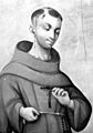
Spanish priest Francisco Garcés arrived in the Bakersfield area in 1776.
-
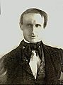
Bakersfield is named after Thomas Baker, who came to the area in 1863.
-
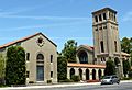
The First Baptist Church, built in 1931 in a Spanish Colonial Revival style is listed on the National Register of Historic Places.
-
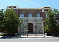
The Bakersfield Californian Building is also listed on the NRHP.


.jpg)

See also
 In Spanish: Bakersfield (California) para niños
