
Bangka Belitung Islands facts for kids
Quick facts for kids
Bangka Belitung Islands
|
|||
|---|---|---|---|
|
|||
| Motto(s):
Serumpun Sebalai
(Allied Disgust) |
|||

Location of Bangka Belitung in Indonesia
|
|||
| Established | 4 December 2000 | ||
| Capital and largest city |
Pangkal Pinang | ||
| Government | |||
| • Body | Bangka Belitung Islands Provincial Government | ||
| Area | |||
| • Total | 16,424.14 km2 (6,341.40 sq mi) | ||
| Area rank | 27th in Indonesia | ||
| Highest elevation | 669 m (2,195 ft) | ||
| Population
(2017)
|
|||
| • Total | 1,430,900 | ||
| • Rank | 29th in Indonesia | ||
| • Density | 87.1218/km2 (225.644/sq mi) | ||
| • Density rank | |||
| Demographics | |||
| • Ethnic groups |
|
||
| • Religion |
|
||
| • Languages |
|
||
| Time zone | UTC+7 (Indonesia Western Time) | ||
| HDI | |||
| HDI rank | 15th in Indonesia (2014) | ||


The Bangka Belitung Islands (Indonesian: Kepulauan Bangka Belitung) is a province of Indonesia. It is made up of two main islands, Bangka and Belitung, and several smaller ones.
Bangka Belitung is bordered by the Bangka Strait to the west, the Natuna Sea to the north, the Java Sea is to the south, and the Karimata Strait to the east.
The province's capital and largest city is Pangkal Pinang. As of the 2015 census, the population of Bangka Belitung was 1,372,813.
Images for kids
-
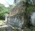
The fort of Toboali was built in 1825 to defend Bangka's tin mines
-
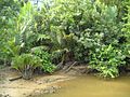
Marsh ecosystem in Bangka Island
-
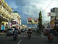
Pangkal Pinang, the capital city as well as the largest city in the province.
-
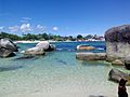
Tanjung Tinggi Beach. Bangka Belitung has significant areas of open sea and islands.
-
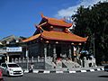
A Taoist temple in Pangkalpinang


See also
 In Spanish: Provincia de Bangka-Belitung para niños
