
Bargara, Queensland facts for kids
Quick facts for kids BargaraQueensland |
|||||||||||||||
|---|---|---|---|---|---|---|---|---|---|---|---|---|---|---|---|
 |
|||||||||||||||

Bargara
Location in Queensland
|
|||||||||||||||
| Population | 7,485 (2016 census) | ||||||||||||||
| • Density | 805/km2 (2,080/sq mi) | ||||||||||||||
| Postcode(s) | 4670 | ||||||||||||||
| Elevation | 0–10 m (0–33 ft) | ||||||||||||||
| Area | 9.3 km2 (3.6 sq mi) | ||||||||||||||
| Time zone | AEST (UTC+10:00) | ||||||||||||||
| Location |
|
||||||||||||||
| LGA(s) | Bundaberg Region | ||||||||||||||
| State electorate(s) | Burnett | ||||||||||||||
| Federal Division(s) | Hinkler | ||||||||||||||
|
|||||||||||||||
Bargara is a coastal town and suburb in the Bundaberg Region, Queensland, Australia. In the 2016 census the suburb of Bargara had a population of 7,485 people.
The town of Bargara lies 384 kilometres (239 mi) north of the state capital Brisbane and just 13 kilometres (8 mi) east of Bundaberg. Bargara is considered to be a satellite suburb of Bundaberg, with only sugar cane fields separating the two centres.
Nielson Park is a coastal town in the north of the locality (24°48′27″S 152°27′24″E / 24.8075°S 152.4566°E), only 1.5 kilometres (0.93 mi) from the town of Bargara.
Contents
History

Prior to 1913, Bargara was officially known as Sandhills. The Sandhills Provisional School opened in 1893, and was renamed Bargara State School in 1921. The name Bargara is derived from the names of two adjacent localities, Barolin and Woongarra.
Bargara Post Office opened by 1923 (a receiving office had been open since 1912).
On Australia Day 2013, Bargara was struck by a tornado spawned by ex-Tropical Cyclone Oswald. The tornado damaged over 150 properties, and injured up to 17 people, 2 seriously.
Demographics
According to the 2016 census, there were 7,485 people living in Bargara.
- Aboriginal and Torres Strait Islander people made up 2.7% of the population.
- 76.3% of people were born in Australia. The next most common countries of birth were England 6.4%, New Zealand 3.2% and South Africa 1.6%.
- 90.8% of people only spoke English at home.
- The most common responses for religion were No Religion 25.3%, Anglican 21.3%, Catholic 19.9% and Uniting Church 7.6%.
Religion
- St Peter's Anglican Church, corner of Tanner and Bauer Streets
- Bargara Uniting Church, corner of Hughes Road and Blain Street
Transport
The town is serviced by the main roads of Bargara Road, Bauer Street, See Street, The Esplanade, Miller Street and Woongarra Scenic Drive.
Bus route no. 4 connects Bargara with the City and Sugarland Shopping Centre, running 7 days a week via Bauer Street, The Esplanade, Miller Street and Innes Park North.
Parks and open spaces
- Bargara Esplanade
- Nelson's Park
- Bell Fritz Park
- Mary Kinross Memorial Park
- Bargara Rotary Park
- Kelly's Beach Park
Sport
- Bargara Golf Club
- Sandhills Sprorts Club
- Bundaberg Surf Lifesaving Club
- Bargara Football Club
Gallery
-
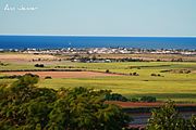
View from the Hummock
-
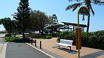
Bus stop on The Esplanade
-
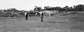
Bargara Golf Club, c. 1931
-
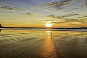
Kelly's Beach Sunrise


Education
There are no schools in Bargara. The nearest government primary school is Bargara State School in neighbouring Mon Repos to the north-west. The nearest government secondary school is Kepnock State High School in Kepnock, Bundaberg, to the south-west.
Images for kids
-
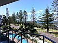
Bargara foreshore, looking through Norfolk Island Pines to the Coral Sea, 2011

