
Barringun, Queensland facts for kids
Quick facts for kids BarringunQueensland |
|||||||||||||||
|---|---|---|---|---|---|---|---|---|---|---|---|---|---|---|---|

Barringun
Location in Queensland
|
|||||||||||||||
| Population | 7 (2016 census) | ||||||||||||||
| • Density | 0.0075/km2 (0.019/sq mi) | ||||||||||||||
| Postcode(s) | 4490 | ||||||||||||||
| Area | 932.8 km2 (360.2 sq mi) | ||||||||||||||
| Time zone | AEST (UTC+10:00) | ||||||||||||||
| Location |
|
||||||||||||||
| LGA(s) | Shire of Paroo | ||||||||||||||
| State electorate(s) | Warrego | ||||||||||||||
| Federal Division(s) | Maranoa | ||||||||||||||
|
|||||||||||||||
Barringun is a rural locality in the Shire of Paroo, Queensland, Australia. It is on the border of Queensland and New South Wales. In the 2016 census, Barringun had a population of 7 people.
The former border town of Wooroorooka is within the south-west of the locality (28°58′00″S 145°42′00″E / 28.9667°S 145.7000°E).
Contents
History
The name Barringun derives from an early settlement (possibly a pastoral station) on the Warrego River, which can be seen on an 1887 map as being just south of the New South Wales border. It is possibly an Aboriginal word meaning fish die in the water.
Heritage listings
Barringun has a heritage-listed site: East Bank, Warrego River at the border with New South Wales: Zero Obelisk
Education
There are no schools in Barringun. The nearest primary and secondary schools are in Cunnamulla, approximately 107 kilometres (66 mi) away. Distance education and boarding schools are the alternatives.
Images for kids
-
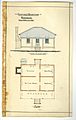
Architectural drawings of the Barringun Customs Quarters, 1885
-
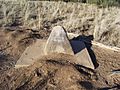
Zero Obelisk
_Customs_Quarters,_1885.jpg)

