
Bath County, Virginia facts for kids
Quick facts for kids
Bath County
|
|
|---|---|

Bath County Courthouse in Warm Springs
|
|

Location within the U.S. state of Virginia
|
|
 Virginia's location within the U.S. |
|
| Country | |
| State | |
| Founded | 1790 |
| Named for | Bath, England |
| Seat | Warm Springs |
| Largest community | Hot Springs |
| Area | |
| • Total | 535 sq mi (1,390 km2) |
| • Land | 529 sq mi (1,370 km2) |
| • Water | 5 sq mi (10 km2) 1.0% |
| Population
(2020)
|
|
| • Total | 4,209 |
| • Density | 7.867/sq mi (3.038/km2) |
| Time zone | UTC−5 (Eastern) |
| • Summer (DST) | UTC−4 (EDT) |
| Congressional district | 6th |
Bath County is a United States county on the central western border of the Commonwealth of Virginia, on the West Virginia state line. As of the 2020 census, the population was 4,209, the second-least populous county in Virginia. Bath's county seat is Warm Springs.
Contents
History
Bath County was established on December 14, 1790 from sections of Augusta, Botetourt, and Greenbrier counties. Due to the many mineral springs found in the area, the county was named for the English spa and resort city of Bath. The area's economy has focused on tourism and travel since the 1700s, particularly when The Homestead Resort was built in 1766.
Located along the western central border with West Virginia, Bath County comprises a number of villages, including Hot Springs, Warm Springs, Millboro and Mountain Grove. Hot Springs and Warm Springs are the most well known of the villages, given their natural mineral springs. Bath County is one of the few counties in Virginia without a traffic signal. (Charlotte County, Mathews County, and Rappahannock County are the others.)
Geography
According to the U.S. Census Bureau, the county has a total area of 535 square miles (1,390 km2), of which 529 square miles (1,370 km2) is land and 5 square miles (13 km2) (1.0%) is water. 89% of Bath County is forest, with 51% national forest and 6% state park. The Nature Conservancy owns more than 9,000 acres (36 km2) of forest habitat.
Adjacent Counties
- Highland County – north
- Augusta County – northeast
- Rockbridge County – east
- Alleghany County – south
- Greenbrier County, West Virginia – southwest
- Pocahontas County, West Virginia – west
National protected areas
- George Washington National Forest (part)
- United States National Radio Quiet Zone (part)
Major highways
 US 220
 SR 39
SR 39 SR 42
SR 42
Demographics
| Historical population | |||
|---|---|---|---|
| Census | Pop. | %± | |
| 1800 | 5,508 | — | |
| 1810 | 4,837 | −12.2% | |
| 1820 | 5,237 | 8.3% | |
| 1830 | 4,002 | −23.6% | |
| 1840 | 4,300 | 7.4% | |
| 1850 | 3,486 | −18.9% | |
| 1860 | 3,676 | 5.5% | |
| 1870 | 3,795 | 3.2% | |
| 1880 | 4,482 | 18.1% | |
| 1890 | 4,587 | 2.3% | |
| 1900 | 5,595 | 22.0% | |
| 1910 | 6,538 | 16.9% | |
| 1920 | 6,389 | −2.3% | |
| 1930 | 8,137 | 27.4% | |
| 1940 | 7,191 | −11.6% | |
| 1950 | 6,296 | −12.4% | |
| 1960 | 5,335 | −15.3% | |
| 1970 | 5,192 | −2.7% | |
| 1980 | 5,860 | 12.9% | |
| 1990 | 4,799 | −18.1% | |
| 2000 | 5,048 | 5.2% | |
| 2010 | 4,731 | −6.3% | |
| 2020 | 4,209 | −11.0% | |
| U.S. Decennial Census 1790-1960 1900-1990 1990-2000 2010 2020 |
|||
2020 census
| Race / Ethnicity | Pop 2010 | Pop 2020 | % 2010 | % 2020 |
|---|---|---|---|---|
| White alone (NH) | 4,363 | 3,941 | 92.22% | 91.26% |
| Black or African American alone (NH) | 213 | 114 | 4.50% | 2.71% |
| Native American or Alaska Native alone (NH) | 5 | 3 | 0.11% | 0.07% |
| Asian alone (NH) | 7 | 17 | 0.15% | 0.40% |
| Pacific Islander alone (NH) | 0 | 1 | 0.00% | 0.02% |
| Some Other Race alone (NH) | 5 | 4 | 0.11% | 0.10% |
| Mixed Race/Multi-Racial (NH) | 37 | 156 | 0.78% | 3.71% |
| Hispanic or Latino (any race) | 101 | 73 | 2.13% | 1.73% |
| Total | 4,731 | 4,209 | 100.00% | 100.00% |
Note: the US Census treats Hispanic/Latino as an ethnic category. This table excludes Latinos from the racial categories and assigns them to a separate category. Hispanics/Latinos can be of any race.
Communities
Census-designated places
Other unincorporated communities
Economy
Tourism and recreation have been the focus of the economy from the time the county was established. The Omni Homestead, a luxury mountain resort in Hot Springs, is the county's major employer.
The resort grew around the area's mineral springs, such as the Jefferson Pools. (As of July 1, 2018, the Jefferson Pools have been closed by the resort. The pools are anticipated to reopen once the safety of their surrounding structures is verified.)
Bath County is also home to the Bath County Pumped Storage Station, a pumped storage hydroelectric power plant.
Education
The county has two elementary schools (serving students from pre-kindergarten to seventh grade) and one high school (serving students in grades 8 through 12). Around 555 students are enrolled in the school system.
Notable people
- Creigh Deeds, Virginia Senator (25th District)
- Jailyn Ford, NPF pitcher
- Dan Ingalls, computer scientist, president of the Homestead
- John Phillips, NFL tight end
- Sam Snead, professional golfer
Images for kids
-
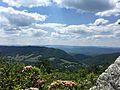
Warm Springs Valley

See also
 In Spanish: Condado de Bath (Virginia) para niños
