
Batura Muztagh facts for kids
Quick facts for kids Batura Muztagh |
|
|---|---|

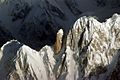
View of part of the Batura Muztagh
|
|
| Highest point | |
| Peak | Batura Sar |
| Elevation | 7,795 m (25,574 ft) |
| Naming | |
| Native name | Error {{native name}}: an IETF language tag as parameter {{{1}}} is required (help) |
| Geography | |
| Country | Pakistan |
| State/Province | Gilgit District |
| Parent range | Karakoram |
The Batura Muztagh is a group of mountains in the Karakoram mountain range. It was what is called a subrange, or a smaller mountain range inside of a larger one. It is located in Gilgit-Baltistan, in Pakistan.
Batura Muztagh is the most western of the Karakoram subranges. It runs from Chalt village in Bar Valley in the east to Kampir Dior in the Kurumbar Valley in the west. This subrange included Muchu Chhish, which is the second highest unclimbed mountain in the world.
Contents
Selected mountains
| Mountain | Height (m) | Height (ft) | Coordinates | Prominence (m) | Parent mountain | First ascent | Ascents (attempts) |
|---|---|---|---|---|---|---|---|
| Batura Sar | 7,795 | 25,574 | 36°30′36″N 74°31′27″E / 36.51000°N 74.52417°E | 3,118 | Distaghil Sar | 1976 | 4 (6) |
| Shispare | 7,611 | 24,970 | 36°26′26″N 74°40′51″E / 36.44056°N 74.68083°E | 1,240 | Batura Sar | 1974 | 3 (1) |
| Passu Sar | 7,476 | 24,528 | 36°29′16″N 74°35′16″E / 36.48778°N 74.58778°E | 645 | Batura Sar | 1994 | 1 (0) |
| Ultar Sar | 7,388 | 24,239 | 36°23′54″N 74°42′32″E / 36.39833°N 74.70889°E | 700 | Shispare | 1996 | 2 (5) |
| Sangemarmar Sar | 7,000 | 22,966 | 36°25′31″N 74°33′38″E / 36.42528°N 74.56056°E | 1,100 | Pasu Sar | 1984 | 1 (3) |
| Bublimotin (Ladyfinger Peak) | 6,000 | 19,685 | 36°22′12″N 74°39′00″E / 36.37000°N 74.65000°E | <200 | Hunza Peak | 1982 | 2 (5) |
Books and maps about Batura Muztagh
- High Asia: An Illustrated History of the 7000 Metre Peaks by Jill Neate, ISBN: 0-89886-238-8
- Batura Mustagh (sketch map and pamphlet) by Jerzy Wala, 1988.
- Orographical Sketch Map of the Karakoram by Jerzy Wala, 1990. Published by the Swiss Foundation for Alpine Research.
Related pages
- This data is from the Himalayan Index and is not always correct. In particular it is not clear if Batura Sar has really had four ascents or only three.
- Sometimes called Batura I.
- Sometimes called Ultar II or Bojohagur Duanasir II.
- Also known as Sang-e-Marmar (or Sangemarmar), and sometimes as Marble Peak.
- The heights given for this peak vary between 6949 m and 7050 m.
- This elevation is approximate.
Images for kids
-
Bublimotin and Hunza Peak, southeastern Batura Muztagh

See also
 In Spanish: Batura Muztagh para niños

All content from Kiddle encyclopedia articles (including the article images and facts) can be freely used under Attribution-ShareAlike license, unless stated otherwise. Cite this article:
Batura Muztagh Facts for Kids. Kiddle Encyclopedia.