
Bayswater, Western Australia facts for kids
Quick facts for kids BayswaterPerth, Western Australia |
|||||||||||||||
|---|---|---|---|---|---|---|---|---|---|---|---|---|---|---|---|

View of King William Street south from the Bayswater Subway in October 2020
|
|||||||||||||||

Bayswater
Location in Perth
|
|||||||||||||||
| Population | 14,432 (2016 census) | ||||||||||||||
| • Density | 1,468.2/km2 (3,803/sq mi) | ||||||||||||||
| Established | 1885 | ||||||||||||||
| Postcode(s) | 6053 | ||||||||||||||
| Area | 9.83 km2 (3.8 sq mi) | ||||||||||||||
| Location | 6 km (4 mi) from Perth | ||||||||||||||
| LGA(s) | City of Bayswater | ||||||||||||||
| State electorate(s) | Maylands, Bassendean | ||||||||||||||
| Federal Division(s) | Perth | ||||||||||||||
|
|||||||||||||||
Bayswater is a suburb 6 km (4 mi) north-east of the central business district (CBD) of Perth, the capital of Western Australia. It is just north of the Swan River, within the City of Bayswater local government area. It is predominantly a low-density residential suburb consisting of single-family detached homes. However, there are several clusters of commercial buildings, most notably in the suburb's town centre, around the intersection of Whatley Crescent and King William Street and a light industrial area in the suburb's east.
Prior to European settlement, the Mooro group of the Whadjuk Noongar people inhabited the area. In 1830, the year after the European settlement of the Swan River Colony, land along the river was divided between the colonists, who moved in soon after. Most either died or left in the months following, leaving the area undeveloped for most of the 19th century. In 1881, the Fremantle–Guildford railway line was built, triggering the founding of the Bayswater Estate, the first development in the area, and in 1897, the Bayswater Road Board was founded, giving Bayswater its own local government. At first, development consisted of nurseries, market gardens and dairies, but as time went on, Bayswater became more and more suburban. Today, Bayswater is fully suburbanised, with the subdividing of older lots being commonplace. Plans for apartments around Bayswater and Meltham railway stations are a contentious issue.
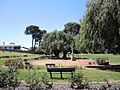
Parks and wetlands, including the Baigup Wetlands, the Eric Singleton Bird Sanctuary and Riverside Gardens. There are other parks throughout the suburb, including Bert Wright Park, Halliday Park (which includes a war memorial), Hillcrest Reserve and Houghton Park line Bayswater's Swan River foreshore. Major roads through the suburb include Guildford Road, which connects to the Perth CBD and Tonkin Highway.
History
Aboriginal people of the Noongar language group originally inhabited the Bayswater area, the occupants of the north bank of the Swan being among Yellagonga’s people, who ranged systematically over a wide area of the coastal plain. The population was rich and complex in culture, sparse in number and nomadic in habit. Its movements were governed by the seasonal availability of food. The Aborigines were hunters and gatherers, who regularly burnt the bush to assist them in both pursuits. They concentrated their activities in the most fertile areas, including the peninsula in nearby Maylands. A large Aboriginal base camp, at least 4,500 years old lies under the Tonkin Highway, just to the north of Guildford Road.
The initial European settlement of Western Australia began in 1829, following the second landing of James Stirling in June of that year. Development was initially sparse along the route of Guildford Road, and Bayswater remained predominately undeveloped until the 1880s. Suburban development began in earnest following the opening of the Fremantle to Guildford railway line in 1881, and Bayswater grew significantly in the period between 1885 and 1920.
Transport
Cars are the most popular mode of transport in Bayswater. The 2011 Census revealed that 62.9% of residents travelled to work in a car. However, bicycle and public transport usage is significantly above the state averages. 15.6% of Bayswater residents said they take public transport to work; the state average is 9.4%, and 2.7% ride a bicycle to work; the state average is 1.1%.
Road
The arterial roads which service Bayswater are Tonkin Highway, Guildford Road, Beechboro Road North, Garratt Road and Grand Promenade. Tonkin Highway is a north–south controlled access highway. Heading north on Tonkin Highway leads to Ellenbrook (20 km (12 mi)) and Joondalup (32 km (20 mi)) via Reid Highway. Heading south, the Redcliffe Bridge carries Tonkin Highway over the Swan River, which leads to Perth Airport, Armadale (33 km (21 mi)) and Roe Highway. The only other bridge over the Swan River in Bayswater is Garratt Road Bridge, which leads to Ascot and Belmont (6 km (3.7 mi)). Heading south west on Guildford Road leads to Maylands and the Perth CBD (6 km (3.7 mi)). Heading north-west on Guildford Road leads to Bassendean (4 km (2.5 mi)), Guildford (7 km (4.3 mi)) and Midland (11 km (6.8 mi)). Grand Promenade heads north-west of Bayswater and connects to Alexander Drive, Morley Drive and Dianella. Beechboro Road North heads north of Bayswater, leading to Beechboro and Malaga.
Local distributor roads in Bayswater include Beechboro Road South, Collier Road, Coode Street, King William Street, Walter Road East and Whatley Crescent. Whatley Crescent goes through the town centre and connects to Guildford Road west of Bayswater as another connection to the Perth CBD. Collier Road connects the Bayswater industrial area to Tonkin Highway and Guildford Road, as well as linking Bayswater to the Morley commercial precinct. Beechboro Road South connects the town centre and the industrial area to Broun Avenue, north of Bayswater.
King William Street is the main street through the town centre and the most direct connection between it and Guildford Road. Coode Street connects the town centre to Morley in the north. King William Street and Coode Street connect by an underpass under the railway line. The rail bridge at the underpass is known as the Bayswater Subway or Bayswater Bridge and is notorious for being hit by tall vehicles. There are three other railway line crossings in Bayswater. They are, from east to west, a level crossing connecting Railway Parade and Guildford Road, a bridge carrying Tonkin Highway over the railway line and a bridge connecting Railway Parade and Whatley Crescent near Meltham station. There are four crossings of Tonkin Highway in Bayswater, two of which have an interchange with Tonkin Highway. They are, from north to south, Collier Road, which bridges over the highway and connects as a single-point urban interchange, Railway Parade, which passes under a bridge, Guildford Road, which passes under a bridge and connects as a folded diamond interchange, and Dunstone Road, a minor road which passes under a bridge.
Train

Bayswater is serviced by Bayswater and Meltham stations on the Midland railway line, with commuter services operated by Transperth between Midland and Perth. The currently under construction Airport railway line branches off from the Midland line in Bayswater. When it opens in the first half of 2022, it will connect Bayswater to Perth Airport and High Wycombe. In addition, the Morley–Ellenbrook railway line is currently under planning, set to branch off from the Midland line at Bayswater as well. It is scheduled to open in 2023, creating a public transport connection between Bayswater and Perth's outer north-eastern suburbs. As part of the Morley-Ellenbrook line project, Morley railway station is set to be constructed just north of Bayswater, which will improve public transport coverage to north-eastern parts of the suburb when it opens. Whatley railway station, in the eastern part of Bayswater near the intersection of Wyatt Road and Higgins Way, was demolished in 1957 following the closure of the Belmont railway line in 1956.
Bus
Transperth bus services in Bayswater include routes 41, 48, 55, 341, 342, 955, 998 and 999. They are operated by Path Transit under contract from Transperth. Path Transit also operates a bus depot in Bayswater. Routes 41, 48 and 55 heading south-west lead to the Perth CBD. In Bayswater, route 41 travels along local streets south of Guildford Road, terminating at Leake Street. Route 48 travels along Guildford Road and King William Street, connecting to Bayswater railway station. North of there, route 48 links to Morley bus station, traversing minor roads along the way. Route 55 travels down Guildford Road and links to Bassendean railway station. Routes 341 and 342 traverse the northern boundary of Bayswater at Walter Road. To the west, they connect to Morley bus station. To the east, they connect to Bassendean railway station and several north-eastern suburbs, including Beechboro. Route 955 travels along Collier Road. To the west, it connects to Morley bus station. To the east, it connects to Bassendean railway station, before heading north to Ellenbrook. Routes 998 and 999, also known as the CircleRoute are a pair of high frequency bus routes which travel in a circuit around Perth. Their route through Bayswater consists of Garratt Road, Guildford Road, King William Street and Coode Street. They have a connection at Bayswater railway station. 998 travels south through Bayswater, and 999 travels north through Bayswater. The CircleRoute provides a connection to Morley bus station, Dianella Plaza and Stirling railway station to the north, and Ascot Racecourse, Belmont Forum and Oats Street railway station to the south.
Cycling

Bayswater is well connected by Principal Shared Paths (PSP's). The Midland Railway Line has a PSP alongside it, which leads to the Perth CBD to the west and Midland to the east. Tonkin Highway has a PSP alongside it north of Railway Parade, constructed in 2017 as part of NorthLink WA. There is also a PSP along the river used for recreational cycling.
In 2015, Leake and May Streets were selected to become Perth's first bike boulevards. The speed limit on the bike boulevard is 30 km/h (19 mph), below the standard 50 km/h (31 mph) limit in Australia. Cars are slowed by traffic calming measures. The bike boulevard encourages cycling in the area by linking the river, Bayswater Primary School and the Perth–Midland PSP. The bike boulevard opened in March 2017. In April 2018, the City of Bayswater decided not to go ahead with stage two of the bike boulevard, which would have seen the bike boulevard extended north through Bedford and Morley.
Demographics

Bayswater's population, according to the Australian Bureau of Statistics' 2016 census, was 14,432, an increase over the 13,525 recorded in the 2011 census.
49.1% of residents are male, 50.9% are female. The median age is 38, which is above the Western Australian average of 36, and 44.3% of residents over the age of 15 are married, which is below the state average of 48.8%. Of the suburb's 6,263 dwellings, 5,604 were occupied, 659 were vacant. Of the 5,604 occupied dwellings, 4,387 were detached houses, 1,007 were semi-detached and 196 were apartments or flats. 1,491 were owned outright, 2,309 were owned with a mortgage, 1,586 were rented and 229 were other or not stated. Bayswater's tenure statistics closely align with the state averages. The median weekly household income was $1,705, which is higher than the state and the country, which are at $1,595 and $1,438, respectively. Major industries that residents worked in were school education (4.7%), cafés, restaurants and takeaway food services (4.5%), architectural, engineering and technical services (4.0%), hospitals (3.7%), and state government administration (3.7%). 4% of residents are unemployed, which is below the 2011 state average of 4.7%.
The population of Bayswater is predominantly Australian born, 62.5% of residents, which is around the state average of 62.9%. The next-most-common birthplaces were England (7.0%), New Zealand (2.9%), India (2.9%), Italy (1.6%), and Vietnam (1.2%).
The most common religious affiliations were no religion, with 28.6%, Roman Catholicism (27.4%), Anglicanism (14.9%), Uniting Church (2.7%), and Buddhism (2.4%). Churches in Bayswater include Saint Columba's Catholic Church, an Apostolic Church, and a Russian Orthodox Church, which is the only one in Perth.
Education

The first school to open in Bayswater was Bayswater Primary School, established in 1894 as the Bayswater State School on Murray Street, near the Bayswater town centre. It caters to 60 Kindergarten students and 370 students between Pre-Primary and Year 6 as of 2020. It became an independent public school in 2020, and is listed on the City of Bayswater Local Heritage Survey. The school received a bell from a railway locomotive in 1904. Used to call the children into class, it remains to this day, despite calls for modernisation and is the reason behind the school's motto "Ringing True".
In 1936, St Columba's School, a private Catholic primary school on Roberts Street, opened to students. It caters to almost 500 students from Pre-Kindergarten to Year 6. The church on the site is listed on the City of Bayswater Local Heritage Survey.

The third school and second public school to open in Bayswater is Hillcrest Primary School, which opened in 1950. On Bay View Street, atop the crest of a large hill, it caters to 61 Kindergarten students and 364 Pre-Primary to Year 6 students as of 2020. It became an independent public school in 2020. The school is listed on the City of Bayswater Local Heritage Survey.
In 1985, Durham Road School opened in Bayswater. This school caters to students with intellectual and physical disabilities from Kindergarten to Year 12, serving students from all over Perth. The school had 200 students as of 2020.
There are no secondary schools in Bayswater, but parts of the suburb are in the local intake areas for John Forrest Secondary College and Hampton Senior High School, both of which are independent public schools in Morley for students in Years 7 to 12. Also, just north of the suburb boundary with Bedford is Chisholm Catholic College, a private Catholic high school.
Images for kids
-
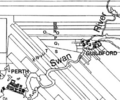
Ribbon grants near the Swan River
-
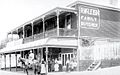
Butcher store on King William Street made of corrugated metal, built in 1906. The building still stands today and is used as a liquor store.
-
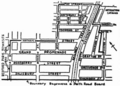
Meltham Heights townsite map published in The West Australian on 27 July 1937
-
Bayswater Post Office, 1942.
-
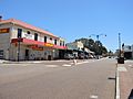
Bayswater town centre, 2020
-
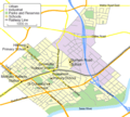
Map of Bayswater
-
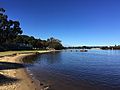
Swan River near Garratt Road Bridge
-
Bayswater Library and Community Centre
-
War Memorial at Halliday Park


.JPG)


.JPG)
.JPG)
