Beaver County, Oklahoma facts for kids
Quick facts for kids
Beaver County
|
|
|---|---|

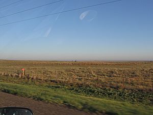
Rural Beaver County (2011)
|
|

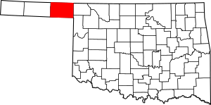
Location within the U.S. state of Oklahoma
|
|
 Oklahoma's location within the U.S. |
|
| Country | |
| State | |
| Founded | 1890 |
| Seat | Beaver |
| Largest town | Beaver |
| Area | |
| • Total | 1,818 sq mi (4,710 km2) |
| • Land | 1,815 sq mi (4,700 km2) |
| • Water | 2.8 sq mi (7 km2) 0.2%% |
| Population
(2010)
|
|
| • Total | 5,636 |
| • Estimate
(2019)
|
5,311 |
| • Density | 3.1/sq mi (1.2/km2) |
| Time zone | UTC−6 (Central) |
| • Summer (DST) | UTC−5 (CDT) |
| Congressional district | 3rd |
Beaver County is a county located in the U.S. state of Oklahoma. As of the 2010 census, the population was 5,636. The county seat is Beaver. The name was given because of the presence of many beaver dams on the Beaver River, which runs through the area. It is located in the Oklahoma Panhandle.
Contents
History
The land where Beaver County is located has been under several jurisdictions. At one time, it was part of Texas before Texas became a state of the United States. Then in the Compromise of 1850, Texas ceded the land that would eventually become the Oklahoma panhandle to the United States government. The area was known as "No Man's Land" because it belonged to no state or territorial government. There was a period of time (1886 - 1890) during which it was a separate organized territory, known as Cimarron Territory. After becoming part of the Oklahoma Territory in 1890, Beaver County (first called Seventh County) covered the entire Oklahoma Panhandle. At statehood in 1907, Cimarron County was taken from the western one-third, while Texas County was taken from the middle, leaving Beaver County only in the east. Its borders are now at 100°W (east), 37°N (north), 36.5°N (south), and approximately 100.8°W (west).
Geography
According to the U.S. Census Bureau, the county has a total area of 1,818 square miles (4,710 km2), of which 1,815 square miles (4,700 km2) is land and 2.8 square miles (7.3 km2) (0.2%) is water. It is the fifth-largest county in Oklahoma by area.
Just north of the town of Beaver is the Beaver Dunes State Park.
Major highways
 U.S. Highway 64
 U.S. Highway 83
 U.S. Highway 270
 U.S. Highway 412
 State Highway 3
 State Highway 23
Adjacent counties
- Meade County, Kansas (north)
- Clark County, Kansas (northeast)
- Harper County (east)
- Ellis County (southeast)
- Lipscomb County, Texas (south)
- Ochiltree County, Texas (southwest)
- Texas County (west)
- Seward County, Kansas (northwest)
Demographics
| Historical population | |||
|---|---|---|---|
| Census | Pop. | %± | |
| 1900 | 3,051 | — | |
| 1910 | 13,631 | 346.8% | |
| 1920 | 14,048 | 3.1% | |
| 1930 | 11,452 | −18.5% | |
| 1940 | 8,648 | −24.5% | |
| 1950 | 7,411 | −14.3% | |
| 1960 | 6,965 | −6.0% | |
| 1970 | 6,282 | −9.8% | |
| 1980 | 6,806 | 8.3% | |
| 1990 | 6,023 | −11.5% | |
| 2000 | 5,857 | −2.8% | |
| 2010 | 5,636 | −3.8% | |
| 2019 (est.) | 5,311 | −5.8% | |
| U.S. Decennial Census 1790-1960 1900-1990 1990-2000 2010-2019 |
|||
As of the 2010 census, there were a total of 5,636 people, 2,192 households, and 1,614 families in the county. The population density was 3 people per square mile (1/km2). There were 2,719 housing units at an average density of 2 per square mile (1/km2). The racial makeup of the county was 92.71% White, 0.29% Black or African American, 1.25% Native American, 0.10% Asian, 0.03% Pacific Islander, 3.76% from other races, and 1.86% from two or more races. 10.76% of the population were Hispanic or Latino of any race.
There were 2,245 households, out of which 33.50% had children under the age of 18 living with them, 66.30% were married couples living together, 6.10% had a female householder with no husband present, and 24.00% were non-families. 22.00% of all households were made up of individuals, and 12.30% had someone living alone who was 65 years of age or older. The average household size was 2.57 and the average family size was 2.99.
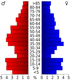
In the county, the population was spread out, with 26.80% under the age of 18, 6.50% from 18 to 24, 25.80% from 25 to 44, 24.10% from 45 to 64, and 16.90% who were 65 years of age or older. The median age was 39 years. For every 100 females, there were 102.20 males. For every 100 females age 18 and over, there were 100.90 males.
The median income for a household in the county was $36,715, and the median income for a family was $41,542. Males had a median income of $31,013 versus $20,162 for females. The per capita income for the county was $17,905. About 8.80% of families and 11.70% of the population were below the poverty line, including 15.80% of those under age 18 and 7.80% of those age 65 or over.
Communities
Towns
Census-designated place
Unincorporated communities
NRHP sites
The following sites in Beaver County are listed on the National Register of Historic Places:
|
|
- Hodges, V. Pauline. "Beaver County," Encyclopedia of Oklahoma History and Culture, 2009. Accessed March 18, 2015.
 |
Seward County, Kansas | Meade County, Kansas | Clark County, Kansas |  |
| Texas County | Harper County | |||
| Ochiltree County, Texas | Lipscomb County, Texas | Ellis County |
Economy
Beaver County's economy has largely been based on agriculture since the turn of the 20th century. At first, the major crop was broomcorn, but that was overtaken by wheat in the 1920s. Railroads connected the county to agricultural markets and stimulated an influx of new farmers. Beginning in 1912, the Wichita Falls and Northwestern Railway built a line from Woodward through Gate to Forgan. Beaver, Meade and Englewood Railroad completed a spur in 1915 from Beaver to Forgan, which was extended westward in 1925–1927 to Hooker. New towns arose along the rail lines or old ones relocated along them.
See also
 In Spanish: Condado de Beaver (Oklahoma) para niños


