
Bellambi, New South Wales facts for kids
Quick facts for kids BellambiWollongong, New South Wales |
|||||||||||||||
|---|---|---|---|---|---|---|---|---|---|---|---|---|---|---|---|

Former site of the South Bulli coal jetty on the northern side of Bellambi Point
|
|||||||||||||||

Bellambi
Location in New South Wales
|
|||||||||||||||
| Population | 3,947 (2016 census) | ||||||||||||||
| Postcode(s) | 2518 | ||||||||||||||
| LGA(s) | City of Wollongong | ||||||||||||||
| State electorate(s) | Keira | ||||||||||||||
| Federal Division(s) | Cunningham | ||||||||||||||
|
|||||||||||||||
Bellambi is a suburb of Wollongong in the Illawarra region of New South Wales, Australia. It has a railway station (opened 1889) on the NSW TrainLink South Coast Line.
Bellambi is situated directly north of Corrimal and east of Russell Vale. It has a beach, Bellambi Beach, on the Wollongong to Thirroul Bike Track.
Bellambi lies on the flat northern Illawarra coastal plain, with views of the escarpment to the west, one of note being Broker's Nose, 440 metres high. To the east is Bellambi Beach and a creek inlet in a reserve, and to the south of the inlet is Bellambi Harbour (formerly known as Port Bellambi) and Bellambi Point.
The original jetty was constructed in 1858. On August 28, 1862, a telegraph line was constructed between Wollongong and Bellambi. In 1863 a second jetty was built at the harbour. In 1887 a new jetty was constructed at Bellambi Bay. In 1927 the Bellambi Mines Rescue Station was established. The public school was opened in 1956. In 1965 the rock pool was under construction.
Images for kids
-
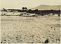
Bellambi Point shell middens and sand dunes, looking south-west (1932). This image pre-dates the destruction of the dunes due to sand mining and construction. Note the prolific artefact scatter.
-
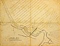
Port Bellambi (1895)
-
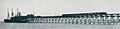
South Bulli Jetty at Port Bellambi c1909.
-
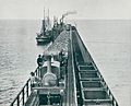
South Bulli Jetty at Bellambi harbour (1909)
.jpg)


