
Belmont County, Ohio facts for kids
Quick facts for kids
Belmont County
|
||
|---|---|---|

|
||
|
||
| Motto(s): | ||

Location within the U.S. state of Ohio
|
||
 Ohio's location within the U.S. |
||
| Country | ||
| State | ||
| Founded | 7 September 1801 (created) 7 November 1801 (organized) |
|
| Named for | "beautiful mountain" in French | |
| Seat | St. Clairsville | |
| Largest city | Martins Ferry | |
| Area | ||
| • Total | 541.27 sq mi (1,401.9 km2) | |
| • Land | 532.13 sq mi (1,378.2 km2) | |
| • Water | 9.14 sq mi (23.7 km2) 1.7%% | |
| Population
(2020)
|
||
| • Total | 66,497 | |
| • Density | 122.8537/sq mi (47.4341/km2) | |
| Time zone | UTC−5 (Eastern) | |
| • Summer (DST) | UTC−4 (EDT) | |
| Congressional district | 6th | |

Belmont County is a county in the U.S. state of Ohio. As of the 2020 United States Census, the population was 66,497. Its county seat is St. Clairsville. The county was created on September 7, 1801, and organized on November 7, 1801. It takes its name from the French for "beautiful mountain".
Belmont County is part of the Wheeling, West Virginia metropolitan area.
Contents
History
Belmont County was formed from Jefferson and Washington counties, September 7, 1801.
In 1976, Belmont County became the first American county to elect a female sheriff, Katherine Crumbly.
In 1987, Michael A Massa, a county resident, created and dedicated the County's first Official Seal and Flag to the people of Belmont County (photo of county seal featured above the county map- see vignette at above right). The citizens of the county held an informal election to select the winning seal and flag, and the event was featured nationally on the Paul Harvey Show.
Geography
According to the U.S. Census Bureau, the county has a total area of 541 square miles (1,400 km2), of which 532 square miles (1,380 km2) is land and 9.1 square miles (24 km2) (1.7%) is water.
Adjacent counties
- Harrison County (north)
- Jefferson County (northeast)
- Ohio County, West Virginia (east)
- Marshall County, West Virginia (southeast)
- Monroe County (south)
- Noble County (southwest)
- Guernsey County (west)
Demographics
| Historical population | |||
|---|---|---|---|
| Census | Pop. | %± | |
| 1810 | 11,097 | — | |
| 1820 | 20,329 | 83.2% | |
| 1830 | 28,627 | 40.8% | |
| 1840 | 30,901 | 7.9% | |
| 1850 | 34,600 | 12.0% | |
| 1860 | 36,398 | 5.2% | |
| 1870 | 39,714 | 9.1% | |
| 1880 | 49,638 | 25.0% | |
| 1890 | 57,413 | 15.7% | |
| 1900 | 60,875 | 6.0% | |
| 1910 | 76,856 | 26.3% | |
| 1920 | 93,193 | 21.3% | |
| 1930 | 94,719 | 1.6% | |
| 1940 | 95,614 | 0.9% | |
| 1950 | 87,740 | −8.2% | |
| 1960 | 83,864 | −4.4% | |
| 1970 | 80,917 | −3.5% | |
| 1980 | 82,569 | 2.0% | |
| 1990 | 71,074 | −13.9% | |
| 2000 | 70,226 | −1.2% | |
| 2010 | 70,400 | 0.2% | |
| 2020 | 66,497 | −5.5% | |
| US Decennial Census 1790-1960 1900-1990 1990-2000 2020 |
|||
2010 census
As of the 2010 United States Census, there were 70,400 people, 28,679 households, and 18,761 families in the county. The population density was 132.3/sqmi (51.1/km2). There were 32,452 housing units at an average density of 61.0/sqmi (23.55/km2). The racial makeup of the county was 94.0% white, 4.0% black or African American, 0.4% Asian, 0.1% American Indian, 0.2% from other races, and 1.3% from two or more races. Those of Hispanic or Latino origin made up 0.6% of the population. In terms of ancestry, 26.0% were German, 17.9% were Irish, 12.4% were English, 10.1% were Italian, 9.0% were Polish, and 6.2% were American.
Of the 28,679 households, 27.2% had children under the age of 18 living with them, 49.2% were married couples living together, 11.4% had a female householder with no husband present, 34.6% were non-families, and 29.9% of all households were made up of individuals. The average household size was 2.32 and the average family size was 2.85. The median age was 43.4 years.
The median income for a household in the county was $38,320 and the median income for a family was $47,214. Males had a median income of $42,022 versus $26,926 for females. The per capita income for the county was $20,266. About 12.1% of families and 15.2% of the population were below the poverty line, including 24.4% of those under age 18 and 9.1% of those age 65 or over.
Communities

Cities
- Martins Ferry
- St. Clairsville (county seat)
Villages
Townships
- Colerain
- Flushing
- Goshen
- Kirkwood
- Mead
- Pease
- Pultney
- Richland
- Smith
- Somerset
- Union
- Warren
- Washington
- Wayne
- Wheeling
- York
Census-designated places
Unincorporated communities
- Alledonia
- Anvil
- Armstrongs Mills
- Badgertown
- Barton
- Blaine
- Boston
- Businessburg
- Captina
- Centerville
- Colerain
- Crescent
- Dilles Bottom
- Egypt
- Fairpoint
- Farmington
- Hendrysburg
- Hunter
- Jacobsburg
- Key
- Lamira
- Lloydsville
- Maynard
- McClainville
- Pleasant Grove
- Riverview
- Sewellsville
- Somerton
- Steinersville
- Stewartsville
- Tacoma
- Temperanceville
- Uniontown
- Warnock
Education
K-12
Belmont County is served by these local schools:
- Barnesville Exempted Village School District
- Bellaire High School
- Belmont County Educational Service Center
- Bridgeport High School
- Buckeye Local High School
- East Richland Christian School
- Harrison Central High School
- Martins Ferry High School
- Olney Friends School
- Saint Clairsville High School
- Shadyside High School
- Union Local High School
- Powhatan Elementary School in Powhatan Point
Higher education
- Belmont College
- Ohio University Eastern Campus
Notable people
- James E. Boyd (1834–1906), mayor of Omaha and the seventh governor of Nebraska
- William Boyd (1895–1972), film and radio actor, portrayed Western character Hopalong Cassidy from 1935 to 1954
- Don Fleming (1937–1963), a graduate of Shadyside High School, played football for the University of Florida and the Cleveland Browns.
- Joey Galloway (1971), a graduate of Bellaire High School, played football for Ohio State and in the NFL for 15 years.
- John Havlicek (1940–2019), a graduate of Bridgeport High School, played basketball for Ohio State and the Boston Celtics in the NBA. Elected to Hall of Fame.
- Bushrod Johnson (1817–1880), one of the few Confederate States of America generals born in the North, was born in Belmont County.
- Lance Mehl (1958), born in Bellaire. NFL football player
- Stan Olejniczak (1912–1979), born in Neffs. NFL football player
- Wilson Shannon (1802–1877), first native-born governor of Ohio
Images for kids
-
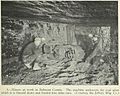
Coal miners in Belmont County, 1923
_(cropped).jpg)
See also
 In Spanish: Condado de Belmont para niños
