
Benson County, North Dakota facts for kids
Quick facts for kids
Benson County
|
|
|---|---|

Benson County Courthouse
|
|

Location within the U.S. state of North Dakota
|
|
 North Dakota's location within the U.S. |
|
| Country | |
| State | |
| Founded | March 9, 1883 (created) June 4, 1884 (organized) |
| Named for | Bertil W. Benson |
| Seat | Minnewaukan |
| Largest community | Fort Totten |
| Area | |
| • Total | 1,439 sq mi (3,730 km2) |
| • Land | 1,389 sq mi (3,600 km2) |
| • Water | 51 sq mi (130 km2) 3.5% |
| Population
(2020)
|
|
| • Total | 5,964 |
| • Estimate
(2021)
|
5,809 |
| • Density | 4.1445/sq mi (1.6002/km2) |
| Time zone | UTC−6 (Central) |
| • Summer (DST) | UTC−5 (CDT) |
| Congressional district | At-large |
Benson County is a county in the U.S. state of North Dakota. As of the 2020 census, the population was 5,964. Its county seat is Minnewaukan. The county was created on March 9, 1883 by the Dakota Territory legislature, and was named for Bertil W. Benson, a Dakota Territory legislator at the time. The county government was organized on June 4, 1884, and its boundary lines were altered by two legislative actions in 1885.
White Horse Hill National Game Preserve and much of the Spirit Lake Indian Reservation are located within the county.
Contents
Geography
According to the U.S. Census Bureau, the county has a total area of 1,439 square miles (3,730 km2), of which 1,389 square miles (3,600 km2) is land and 51 square miles (130 km2) (3.5%) is water.
Adjacent counties
- Towner County (north)
- Ramsey County (northeast)
- Nelson County (east)
- Eddy County (southeast)
- Wells County (southwest)
- Pierce County (west)
Major highways
 U.S. Highway 2
 U.S. Highway 281
 North Dakota Highway 19
 North Dakota Highway 20
 North Dakota Highway 57
National protected areas
- Pleasant Lake National Wildlife Refuge
- Silver Lake National Wildlife Refuge (part)
- Sullys Hill National Game Preserve
- Wood Lake National Wildlife Refuge
Demographics
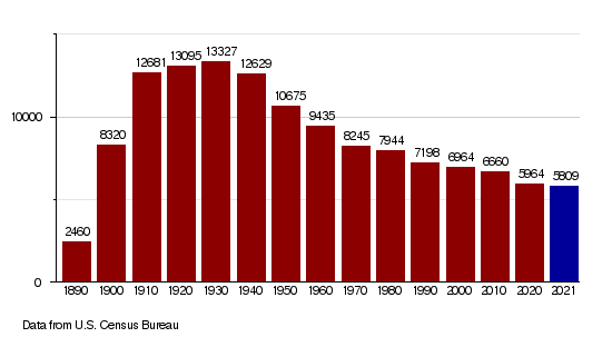
| Historical population | |||
|---|---|---|---|
| Census | Pop. | %± | |
| 1890 | 2,460 | — | |
| 1900 | 8,320 | 238.2% | |
| 1910 | 12,681 | 52.4% | |
| 1920 | 13,095 | 3.3% | |
| 1930 | 13,327 | 1.8% | |
| 1940 | 12,629 | −5.2% | |
| 1950 | 10,675 | −15.5% | |
| 1960 | 9,435 | −11.6% | |
| 1970 | 8,245 | −12.6% | |
| 1980 | 7,944 | −3.7% | |
| 1990 | 7,198 | −9.4% | |
| 2000 | 6,964 | −3.3% | |
| 2010 | 6,660 | −4.4% | |
| 2020 | 5,964 | −10.5% | |
| 2021 (est.) | 5,809 | −12.8% | |
| U.S. Decennial Census 1790-1960 1900-1990 1990-2000 2010-2020 |
|||
2010 census
As of the 2010 census, there were 6,660 people, 2,233 households, and 1,628 families in the county. The population density was 4.8 inhabitants per square mile (1.9/km2). There were 2,950 housing units at an average density of 2.1 per square mile (0.81/km2). The racial makeup of the county was 55.0% American Indian, 43.4% white, 0.2% from other races, and 1.4% from two or more races. Those of Hispanic or Latino origin made up 1.2% of the population. In terms of ancestry, 22.0% were Norwegian, 18.0% were German, 5.0% were Irish, and 0.6% were American.
Of the 2,233 households, 41.3% had children under the age of 18 living with them, 42.3% were married couples living together, 20.6% had a female householder with no husband present, 27.1% were non-families, and 23.2% of all households were made up of individuals. The average household size was 2.98 and the average family size was 3.46. The median age was 31.6 years.
The median income for a household in the county was $30,479 and the median income for a family was $34,597. Males had a median income of $31,729 versus $25,253 for females. The per capita income for the county was $14,545. About 26.1% of families and 35.6% of the population were below the poverty line, including 48.3% of those under age 18 and 16.9% of those age 65 or over.
Population by decade
Communities
Cities
Townships
- Albert
- Arne
- Aurora
- Beaver
- Broe
- Butte Valley
- East Fork
- Eldon
- Esmond
- Hesper
- Impark
- Iowa
- Irvine
- Isabel
- Knox
- Lake Ibsen
- Lallie
- Leeds
- Lohnes
- McClellan
- Minco
- Mission
- Normania
- North Viking
- Oberon
- Pleasant Lake
- Rich Valley
- Riggin
- Rock
- South Viking
- Twin Lake
- Twin Tree
- Warwick
- West Antelope
- West Bay
- Wood Lake
- York
Census-designated place
Other communities
See also
 In Spanish: Condado de Benson para niños
