Benton County, Iowa facts for kids
Quick facts for kids
Benton County
|
|
|---|---|

|
|

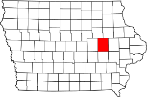
Location within the U.S. state of Iowa
|
|
 Iowa's location within the U.S. |
|
| Country | |
| State | |
| Founded | 1837 |
| Named for | Thomas Hart Benton |
| Seat | Vinton |
| Largest city | Vinton |
| Area | |
| • Total | 718 sq mi (1,860 km2) |
| • Land | 716 sq mi (1,850 km2) |
| • Water | 2.2 sq mi (6 km2) 0.3% |
| Population
(2020)
|
|
| • Total | 25,575 |
| • Density | 35.620/sq mi (13.753/km2) |
| Time zone | UTC−6 (Central) |
| • Summer (DST) | UTC−5 (CDT) |
| Congressional district | 1st |
Benton County is a county in the U.S. state of Iowa. As of the 2020 census, the population was 25,575. Its county seat and largest city is Vinton. The county is named for Thomas Hart Benton, a U.S. Senator from Missouri.
Benton County is part of the Cedar Rapids, IA Metropolitan Statistical Area.
Contents
History
Benton County was formed on December 21, 1837 from sections of Dubuque County. It was named after US Senator Thomas Hart Benton.
Geography
According to the U.S. Census Bureau, the county has a total area of 718 square miles (1,860 km2), of which 716 square miles (1,850 km2) is land and 2.2 square miles (5.7 km2) (0.3%) is water.
Major highways
Adjacent counties
- Black Hawk County (northwest)
- Buchanan County (northeast)
- Linn County (east)
- Iowa County (south)
- Tama County (west)
Demographics
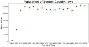
| Historical population | |||
|---|---|---|---|
| Census | Pop. | %± | |
| 1850 | 672 | — | |
| 1860 | 8,496 | 1,164.3% | |
| 1870 | 22,454 | 164.3% | |
| 1880 | 24,888 | 10.8% | |
| 1890 | 24,178 | −2.9% | |
| 1900 | 25,177 | 4.1% | |
| 1910 | 23,156 | −8.0% | |
| 1920 | 24,080 | 4.0% | |
| 1930 | 22,851 | −5.1% | |
| 1940 | 22,879 | 0.1% | |
| 1950 | 22,656 | −1.0% | |
| 1960 | 23,422 | 3.4% | |
| 1970 | 22,885 | −2.3% | |
| 1980 | 23,649 | 3.3% | |
| 1990 | 22,429 | −5.2% | |
| 2000 | 25,308 | 12.8% | |
| 2010 | 26,076 | 3.0% | |
| 2020 | 25,575 | −1.9% | |
| U.S. Decennial Census 1790-1960 1900-1990 1990-2000 2010-2018 |
|||
2020 census
The 2020 census recorded a population of 25,575 in the county, with a population density of 35.6124/sq mi (13.7500/km2). 96.29% of the population reported being of one race. 93.04% were non-Hispanic White, 0.45% were Black, 1.81% were Hispanic, 0.13% were Native American, 0.32% were Asian, 0.01% were Native Hawaiian or Pacific Islander and 4.24% were some other race or more than one race. There were 11,076 housing units of which 10,282 were occupied.
2010 census
The 2010 census recorded a population of 26,076 in the county, with a population density of 36.419/sq mi (14.061/km2). There were 11,095 housing units, of which 10,302 were occupied.
Communities
Cities
Townships
Benton County is divided into twenty townships:
- Benton
- Big Grove
- Bruce
- Canton
- Cedar
- Eden
- Eldorado
- Florence
- Fremont
- Harrison
- Homer
- Iowa
- Jackson
- Kane
- Leroy
- Monroe
- Polk
- St. Clair
- Taylor
- Union
Census-designated place
Population ranking
The population ranking of the following table is based on the 2010 census of Benton County.
† county seat
| Rank | City/Town/etc. | Municipal type | Population (2010 Census) |
|---|---|---|---|
| 1 | † Vinton | City | 5,257 |
| 2 | Belle Plaine | City | 2,534 |
| 3 | Atkins | City | 1,670 |
| 4 | Walford (partially in Linn County) | City | 1,463 |
| 5 | Urbana | City | 1,458 |
| 6 | Shellsburg | City | 983 |
| 7 | Newhall | City | 875 |
| 8 | Blairstown | City | 692 |
| 9 | Van Horne | City | 682 |
| 10 | Keystone | City | 622 |
| 11 | Norway | City | 545 |
| 12 | Garrison | City | 371 |
| 13 | Mount Auburn | City | 150 |
| 14 | Watkins | CDP | 118 |
| 15 | Luzerne | City | 96 |
See also
 In Spanish: Condado de Benton (Iowa) para niños


