
Berkeley Hills facts for kids
Quick facts for kids Berkeley Hills |
|
|---|---|
 |
|
| Highest point | |
| Elevation | 581 m (1,906 ft) |
| Geography | |

Location in California
|
|
| Country | United States |
| State | California |
| District | Alameda County |
| Range coordinates | 37°52′58.732″N 122°14′18.886″W / 37.88298111°N 122.23857944°W |
| Topo map | USGS Briones Valley |
The Berkeley Hills are a range of the Pacific Coast Ranges that overlook the northeast side of the valley that encompasses San Francisco Bay. They were previously called the "Contra Costa Range/Hills" (from the original Spanish Sierra de la Contra Costa), but with the establishment of Berkeley and the University of California, the current usage was applied by geographers and gazetteers.
Contents
Geology
The Berkeley Hills are bounded by the major Hayward Fault along their western base, and the minor Wildcat fault on their eastern side. The highest peaks are Grizzly Peak (elevation 1,754 feet/535 m) and Round Top (elevation 1,761 feet/537 m), an extinct volcano, and William Rust Summit 1,004 feet (306 m).
Vollmer Peak (elevation 1,905 feet/581 m), although commonly thought to be part of the Berkeley Hills is actually located on the adjacent San Pablo Ridge near the point where it meets the Berkeley Hills at the head of Wildcat Canyon. Vollmer Peak was named in honor of the first police chief of the City of Berkeley, August Vollmer. It was formerly known as "Bald Peak".
Usage
It is common to hear the term, "Oakland Hills" to refer to that section of the Berkeley Hills that runs along the east side of Oakland. As a proper name or recognized toponym, it is technically incorrect. When used on maps, the exact south end of the "Berkeley Hills" is unclear, but the maps of the USGS show them stretching well south into the northeastern portion of Oakland. It does not, in any case, correspond to any political boundaries, only to a geographic feature (much as "San Francisco Bay" is not limited to that stretch of the Pacific inlet within the bounds of the City and County of San Francisco). The ridge extends south through Oakland and San Leandro to the drainage of San Leandro Creek called Castro Valley, and geologically, continues southward above the line of the Hayward Fault. In the section above East Oakland to Castro Valley, the ridge appears on most maps as the San Leandro Hills.
The northern extent of the proper name "Berkeley Hills" is less indefinite; most maps including those of the USGS apply the name along the entire ridge as it runs continuously right up to the mouth of Wildcat Canyon in Richmond. The eastern slopes of the Berkeley Hills lie entirely outside of the city of Berkeley within Contra Costa County.
Another common usage is East Bay Hills, but its application to any particular range is unclear. It may refer to all of the ranges east of the Bay, from the Berkeley Hills to the Diablo Range and all the ranges between.
Climatic effects
The Berkeley Hills affect the local climate by their elevation. The oceanic marine layer, which develops during the summer, bringing fog and low clouds with it, is usually less than 2,000 feet deep and thus is blocked by the range. This produces a "fog shadow" effect to the east, which is warmer than areas west of the hills. The westerly wind that carries the marine layer through the Golden Gate typically splits its flow as it hits the Berkeley Hills producing a southerly wind from Berkeley northward and a northerly wind in the direction of Oakland.
In winter during spells of tule fog inland, a reverse situation occurs, with the fog usually confined to areas east of the hills, although occasionally, the inland fog pours in from the north, around the hills by way of the Carquinez Strait.
The Berkeley Hills affect rainfall; when the wind is perpendicular to the hills (southwest wind) during a storm, air is forced to rise, cooling and condensing additional moisture, increasing the precipitation on the western slopes and leaving areas east of the hills drier. Especially cold storms occasionally deposit wet snow on the peaks.
In spring and fall, sinking air from aloft combining with inland high pressure periodically sends hot, dry, and gusty winds across the ridges of the Berkeley Hills, posing a fire danger, which in the 20th century produced several wildfires, two of which caused major damage to Berkeley and Oakland. (See 1923 Berkeley Fire and 1991 Oakland firestorm).
Images for kids
-
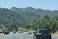
The Berkeley Hills as seen from CA 24 near Orinda.
-
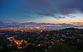
Oakland and the Bay from Grizzly Peak Blvd.


