
Berrigan, New South Wales facts for kids
Quick facts for kids BerriganNew South Wales |
|||||||||
|---|---|---|---|---|---|---|---|---|---|

Chanter Street, Berrigan, looking west; the main street of Berrigan contains a mix of Federation and more-modern architectural styles.
|
|||||||||

Berrigan
Location in New South Wales
|
|||||||||
| Population | 1,260 (2016 census) | ||||||||
| Postcode(s) | 2712 | ||||||||
| Elevation | 119 m (390 ft) | ||||||||
| Location | |||||||||
| LGA(s) | Berrigan Shire | ||||||||
| County | Denison | ||||||||
| State electorate(s) | Murray | ||||||||
| Federal Division(s) | Farrer | ||||||||
|
|||||||||
Berrigan is a town on the Riverina Highway in the Riverina region of New South Wales, Australia. Berrigan is in the Berrigan Shire local government area and contains the Berrigan Shire Council offices. At the 2016 census, Berrigan had a population of 1,260.
History
Berrigan Post Office opened on 11 May 1884.
Because of its location near the border with Victoria, Berrigan was one of the pioneers in the push for an Australian Federation. It was at the suggestion of the Berrigan Australian Natives' Association that the first meeting of the Federation League was held. Due to its centrality, the meeting was held in Corowa.
It is also the birthplace of the New South Wales Rural Fire Service.
Other attractions
The Berrigan Canola festival is held annually in early September. Also held annually is the Berrigan Agricultural Show - Sunday of the October long weekend. It is also close to the Murray River communities of Barooga and Tocumwal.
Once a thriving town with four pubs and the golf club, it has since been reduced to two pubs and the club.
The aging population is well catered for in such a small town, with world class hospice and respite facilities provided. While the town thrives on the farming income generated in the district, it is a very modern, and family-friendly town. In 2013, an Alzheimer's wing was opened, catering to the numerous residents suffering from the disease.
Climate
| Climate data for Berrigan | |||||||||||||
|---|---|---|---|---|---|---|---|---|---|---|---|---|---|
| Month | Jan | Feb | Mar | Apr | May | Jun | Jul | Aug | Sep | Oct | Nov | Dec | Year |
| Average high °C (°F) | 31.9 (89.4) |
31.5 (88.7) |
28.1 (82.6) |
22.8 (73.0) |
18.0 (64.4) |
14.0 (57.2) |
13.5 (56.3) |
15.4 (59.7) |
19.0 (66.2) |
22.9 (73.2) |
27.1 (80.8) |
30.4 (86.7) |
22.9 (73.2) |
| Average low °C (°F) | 15.8 (60.4) |
15.8 (60.4) |
13.2 (55.8) |
9.2 (48.6) |
6.2 (43.2) |
3.8 (38.8) |
3.1 (37.6) |
3.9 (39.0) |
5.8 (42.4) |
8.3 (46.9) |
11.3 (52.3) |
13.9 (57.0) |
9.2 (48.6) |
| Average precipitation mm (inches) | 30.6 (1.20) |
31.2 (1.23) |
34.6 (1.36) |
34.6 (1.36) |
41.2 (1.62) |
43.1 (1.70) |
39.7 (1.56) |
42.9 (1.69) |
38.8 (1.53) |
42.3 (1.67) |
31.7 (1.25) |
33.0 (1.30) |
443.8 (17.47) |
Sport

Popular sports in Berrigan include Australian rules football (the town has a team competing in the Picola & District Football League), netball, golf, bowls, and tennis. Horse racing is also popular, with the Berrigan Gold Cup — held on the same day as the Victoria Derby — attracting a large crowd.
Education

Berrigan has a state primary school, with the Catholic primary school having closed at the end of 2020. The nearest high school is in Finley, 22 kilometres (14 mi) to the west. Oaklands has a Central School, that is a part of the Riverina Access Partnership.
Images for kids
-
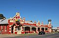
Federal Hotel
-
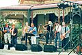
Berrigan Bushdrovers at Nangunia Homestead for the launch of their third album in 2004


