
Berwick, Maine facts for kids
Quick facts for kids
Berwick, Maine
|
|
|---|---|

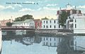
Sullivan Square in 1907
|
|
| Nickname(s):
The Berwicks
|
|
| Motto(s):
Where Tradition Meets Tomorrow
|
|

Berwick, Maine
Location in Maine
|
|
| Country | United States |
| State | Maine |
| County | York |
| Incorporated | 1713 |
| Government | |
| • Type | Town Manager Plan |
| Area | |
| • Total | 37.86 sq mi (98.06 km2) |
| • Land | 37.52 sq mi (97.18 km2) |
| • Water | 0.34 sq mi (0.88 km2) |
| Elevation | 338 ft (103 m) |
| Population
(2020)
|
|
| • Total | 7,950 |
| • Density | 212/sq mi (81.8/km2) |
| Time zone | UTC−5 (Eastern (EST)) |
| • Summer (DST) | UTC−4 (EDT) |
| ZIP Code |
03901
|
| Area code(s) | 207 |
| FIPS Code | 23-23031 |
| Website | www.berwickmaine.org |
Berwick is a town in York County, Maine, United States, situated in the southern part of the state beside the Salmon Falls River.
Today's South Berwick was set off from Berwick in 1814, North Berwick in 1831.
The population was 7,950 at the 2020 census. It is part of the Portland–South Portland–Biddeford, Maine metropolitan statistical area.
History
Originally part of Kittery, the area later comprised by Berwick was settled about 1631 and called Kittery Commons or Kittery North Parish. It was later called Unity after the ship that transported Scots prisoners of war from the Battle of Dunbar in 1650 to the colonies. (These Scots had been force-marched to Durham Cathedral in Durham, England, then tried for treason for supporting Charles II rather than Oliver Cromwell, Lord Protector. Many settled near Berwick in an area near the northern Eliot-York border, which came to be known – and still is – as Scotland Bridge.)
Landing in Massachusetts, the royalist soldiers were sold as indentured servants, many of whom went to work at the Great Works sawmill, located on the Great Works River, until they were able to pay for their own freedom. (George Gray, formerly of Lanark, Scotland, was an example of the 150 prisoners who endured this ordeal. In 1675, he defended his family and lands when the community was attacked during King Philip's War, and died in Unity in 1693. His descendants would populate other areas of Maine, notably Deer Isle and Stonington, Maine).
The raid by Indians in 1675 was the first of several during what was known as King Philip's War. In 1690–1691 during King William's War, the village was burned and abandoned in the Raid on Salmon Falls. It was resettled in 1703 and called Newichawannock, its old Abenaki name. In 1713, it was incorporated by the Massachusetts General Court as Berwick, after Berwick-upon-Tweed, England. The first schoolhouse in the state was built here in 1719. The town was raided numerous times during Father Rale's War. Berwick was once considerably larger in size, but South Berwick was set off in 1814, followed by North Berwick in 1831. Lumbering was a principal early industry. The first lumber exported from the American colonies was clapbords and barrel staves loaded aboard Pied Cowe at South Berwick in 1634. Beginning in the 19th century, Berwick had a symbiotic economic relationship with Somersworth, New Hampshire, the mill town to which it is connected by bridge.
-
Berwick as seen from Somersworth, NH c. 1912
-
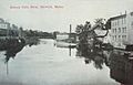
Looking up the Salmon Falls River in 1915
-
Rochester Street from the river in 1921
-
Old Sullivan High School about 1920


Geography
According to the United States Census Bureau, the town has a total area of 37.86 square miles (98.06 km2), of which, 37.52 square miles (97.18 km2) of it is land and 0.34 square miles (0.88 km2) is water. Berwick is drained by the Little River and Salmon Falls River. Diamond Hill, elevation 490 feet (149.4 m) above sea level, is the town's highest point. The lowest elevation, which is approximately 70 feet (21.3 m) above sea level, is on the Salmon River as it crosses the southern most town border with South Berwick.
The town is served by state routes 9 and 236.
Climate
This climatic region is typified by large seasonal temperature differences, with warm to hot (and often humid) summers and cold (sometimes severely cold) winters. According to the Köppen Climate Classification system, Berwick has a humid continental climate, abbreviated "Dfb" on climate maps.
Demographics
| Historical population | |||
|---|---|---|---|
| Census | Pop. | %± | |
| 1790 | 3,894 | — | |
| 1800 | 3,891 | −0.1% | |
| 1810 | 4,455 | 14.5% | |
| 1820 | 2,736 | −38.6% | |
| 1830 | 3,168 | 15.8% | |
| 1840 | 1,698 | −46.4% | |
| 1850 | 2,121 | 24.9% | |
| 1860 | 2,155 | 1.6% | |
| 1870 | 2,291 | 6.3% | |
| 1880 | 2,774 | 21.1% | |
| 1890 | 2,294 | −17.3% | |
| 1900 | 2,280 | −0.6% | |
| 1910 | 2,098 | −8.0% | |
| 1920 | 2,057 | −2.0% | |
| 1930 | 1,961 | −4.7% | |
| 1940 | 1,971 | 0.5% | |
| 1950 | 2,166 | 9.9% | |
| 1960 | 2,738 | 26.4% | |
| 1970 | 3,136 | 14.5% | |
| 1980 | 4,149 | 32.3% | |
| 1990 | 5,995 | 44.5% | |
| 2000 | 6,353 | 6.0% | |
| 2010 | 7,246 | 14.1% | |
| 2020 | 7,950 | 9.7% | |
2010 census
As of the census of 2010, there were 7,246 people, 2,749 households, and 2,029 families residing in the town. The population density was 193.1 inhabitants per square mile (74.6/km2). There were 2,934 housing units at an average density of 78.2 per square mile (30.2/km2). The racial makeup of the town was 96.2% White, 0.5% African American, 0.2% Native American, 1.3% Asian, 0.2% from other races, and 1.6% from two or more races. Hispanic or Latino of any race were 1.3% of the population.
There were 2,749 households, of which 36.9% had children under the age of 18 living with them, 58.1% were married couples living together, 10.7% had a female householder with no husband present, 5.0% had a male householder with no wife present, and 26.2% were non-families. 20.6% of all households were made up of individuals, and 6.6% had someone living alone who was 65 years of age or older. The average household size was 2.62 and the average family size was 3.01.
The median age in the town was 39.1 years. 25.2% of residents were under the age of 18; 6.7% were between the ages of 18 and 24; 26.9% were from 25 to 44; 30.1% were from 45 to 64; and 11% were 65 years of age or older. The gender makeup of the town was 49.4% male and 50.6% female.
Notable people
- Daniel B. Allyn, Vice Chief of Staff of the United States Army, 2014–2017
- John Jay Butler, minister and professor
- Benjamin Franklin Hayes, legislator and judge
- Frederick Hayes, Civil War veteran, awarded medal of honor
- John Alfred Hayes, Union Army physician
- Jonathan Lethem, writer
- Alphonso M. Lunt, army sergeant
- James Sullivan, seventh governor of Massachusetts
See also
 In Spanish: Berwick (Maine) para niños
