
Bethalto, Illinois facts for kids
Quick facts for kids
Bethalto
|
||
|---|---|---|
|
From top, left to right: Old Bethalto Village Hall and log cabin, Old Downtown, Historic Klein's Store, the current Village Hall, St. Louis Regional Airport, and the Bethalto sign outside Village Hall
|
||
|
||
| Motto(s):
Home of the Eagles
|
||

Location of Bethalto in Madison County, Illinois.
|
||
.svg)
Location of Illinois in the United States
|
||
| Country | United States | |
| State | Illinois | |
| County | Madison | |
| Area | ||
| • Total | 7.64 sq mi (19.79 km2) | |
| • Land | 7.59 sq mi (19.66 km2) | |
| • Water | 0.05 sq mi (0.13 km2) | |
| Population
(2020)
|
||
| • Total | 9,310 | |
| • Density | 1,226.45/sq mi (473.52/km2) | |
| Time zone | UTC-6 (CST) | |
| • Summer (DST) | UTC-5 (CDT) | |
| Area code(s) | 618 | |
| FIPS code | 17-05599 | |
| Wikimedia Commons | Bethalto, Illinois | |


Bethalto is a village located in Madison County, Illinois, United States. Bethalto, like the rest of Madison County, is part of the Illinois Metro East portion of the Greater St. Louis metropolitan area.
Early in its history, the village was a railway town along the Terre Haute and Alton Railroad. In the 19th century, industry in the town included milling of grain from local farms and coal mining. In the early 20th century, the railroad was rerouted to go through nearby Edwardsville. By the mid 20th century, the rail industry had pulled out entirely and the village became known as a bedroom town.
At the 2020 census,the population of Bethalto was 9,310.
Contents
Geography
Bethalto is located at 38°54′15″N 90°2′48″W / 38.90417°N 90.04667°W (38.904197, -90.046579).
According to the 2010 census, Bethalto has a total area of 7.6 square miles (19.68 km2), of which 7.52 square miles (19.48 km2) (or 98.95%) is land and 0.08 square miles (0.21 km2) (or 1.05%) is water.
History
Bethalto was founded in 1834, incorporated April 19, 1869, under a special charter and again in 1873 under the State of Illinois' general law. It is governed by a Village President and six trustees elected at large.
The original name of Bethalto was Bethel. However, when the first post office was established, it was discovered that there was already a Bethel, Illinois. There is a general consensus that the name "Bethalto" came from the first four letters of Bethel and the first four letters of nearby Alton.
The Bethalto Village Hall is listed on the National Register of Historic Places.
Demographics
| Historical population | |||
|---|---|---|---|
| Census | Pop. | %± | |
| 1880 | 628 | — | |
| 1890 | 879 | 40.0% | |
| 1900 | 477 | −45.7% | |
| 1910 | 447 | −6.3% | |
| 1920 | 471 | 5.4% | |
| 1930 | 687 | 45.9% | |
| 1940 | 1,207 | 75.7% | |
| 1950 | 2,115 | 75.2% | |
| 1960 | 3,235 | 53.0% | |
| 1970 | 7,074 | 118.7% | |
| 1980 | 8,630 | 22.0% | |
| 1990 | 9,507 | 10.2% | |
| 2000 | 9,454 | −0.6% | |
| 2010 | 9,521 | 0.7% | |
| 2020 | 9,310 | −2.2% | |
| U.S. Decennial Census | |||
As of the census of 2000, there were 9,454 people, 3,810 households, and 2,647 families residing in the village. The population density was 1,437.3 people per square mile (554.7/km2). There were 4,007 housing units at an average density of 609.2 per square mile (235.1/km2). The racial makeup of the village was 97.84% White, 0.76% African American, 0.22% Native American, 0.40% Asian, 0.33% from other races, and 0.44% from two or more races. Hispanic or Latino of any race were 1.00% of the population.
There were 3,810 households, out of which 34.1% had children under the age of 18 living with them, 54.2% were married couples living together, 11.7% had a female householder with no husband present, and 30.5% were non-families. 26.8% of all households were made up of individuals, and 12.5% had someone living alone who was 65 years of age or older. The average household size was 2.46 and the average family size was 2.98.
In the village, the population was spread out, with 25.7% under the age of 18, 8.5% from 18 to 24, 28.7% from 25 to 44, 22.9% from 45 to 64, and 14.1% who were 65 years of age or older. The median age was 37 years. For every 100 females, there were 91.3 males. For every 100 females age 18 and over, there were 85.0 males.
The median income for a household in the village was $42,201, and the median income for a family was $50,764. Males had a median income of $41,512 versus $22,981 for females. The per capita income for the village was $18,697. About 6.5% of families and 9.2% of the population were below the poverty line, including 13.1% of those under age 18 and 6.4% of those age 65 or over.
Parks and recreation
Bethalto Municipal Park
The main park in Bethalto consists of a stage amphitheater, swimming pool, lighted tennis courts, baseball fields, soccer fields, skateboard park, and a newly re-modeled basketball court. The park is where the Bethalto Homecoming is held every year. During the event bands play, carnival rides may be ridden for small fees and a variety of culturally diverse food and beverage stands are set up. The park is conveniently located in the center of town, directly adjacent to the village hall.
Bethalto Arboretum


The Bethalto Arboretum is an arboretum on the east end of town that was developed in 1966 after the demise of the railroad era in Bethalto. It is one of the few arboretums in the area. A directory of trees and bushes contained in the arboretum may be viewed in the mayor and clerk's offices. There are also many plaques, in memory of Bethalto's notable persons, placed next to many of the trees in the park. The park is centered on a road truck (Rail Wheels) on top of a short slab of railroad track. The short piece of track remains in its original position as part of the old railroad tracks that existed to transport coal to and from the area.
Culp Lane Park
Culp Lane Park is a large park on the northwest end of town that was established in 2005. Among its many features are a lake (fishing is allowed), a children's play area, and a new arboretum. It has become a popular site for Bethalto residents to come for exercise as well as leisure. The park is a great spot for events like sports parties or picnics. Wilbur Trimpe Middle School goes on class trips to fish there before colder seasons occur.
Bethalto Sports Complex
The Bethalto Sports Complex is located on the north side of town just off Culp Lane. The complex was completed in 2006 and is made up of two baseball fields, two softball fields, two soccer fields, a grandstand, and a concession stand. The complex, which is maintained by the Village of Bethalto, replaced the old baseball and soccer fields located at Civic Memorial High School for varsity and junior varsity baseball, softball and soccer teams. The Indians, the Bethalto Legion team, also calls the complex home.
Khoury League Diamonds
The Bethalto Khoury League Diamonds are located on the south side of town in the Chateaux residential area. The complex consists of four lighted diamonds with a concession stand in the center. The fields are primarily set up to handle all of the local Boys & Girls Clubs of America youth baseball and softball games. The fields are also home to a number of private and select league baseball teams that play there every summer.
Education
Public schools in Bethalto are operated by Bethalto Community Unit School District 8, which was founded in 1950 along with Civic Memorial High School. The village is also home to Our Lady Queen of Peace, a Catholic school founded in 1962 under Father Thomas Manning, and a Lutheran school also founded in 1962, Zion Lutheran. Both parochial schools offer kindergarten through eight grade classes.
Transportation
Highways
Bethalto is connected to the region by several routes. Illinois Route 140 is the main east-west highway running through the village. Illinois Route 111 joins with Illinois Route 140 from the south, connecting the village to the rest of the Metro East. In October 2006, Illinois Route 255, a four-lane, controlled-access highway was extended from Illinois Route 143 in Wood River to Fosterburg Road, just outside of Bethalto. Illinois Route 255 runs into Interstate 255 in Pontoon Beach, Illinois, connecting Bethalto to the Interstate Highway System.
St. Louis Regional Airport
Bethalto is home to St. Louis Regional Airport. Originally called Civic Memorial Airport, St. Louis Regional was founded in 1946 with a ballot measure approving the creation of the Civic Memorial Airport Authority. The airport is home to various services, including West Star Aviation, a fixed-base operator.
Notable people
- Alison Krauss, bluegrass-country singer and musician often rehearsed in Bethalto with Mike Harman and the Harman Family Bluegrass Band. Mike Harman was an original member of Union Station
- Joe Odom (born 1979), American Football player for the Chicago Bears
- Steve Davis (born 1949), former representative in the Illinois General Assembly
- Wilbur Trimpe (1906-1996), first superintendent of Bethalto Community Unit School District 8, third president of Lewis and Clark Community College
Images for kids
-
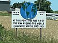
Sign in Meadowbrook, just outside Bethalto marking 90ºW
-
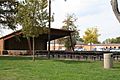
Bandstand in Central Park
-
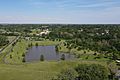
Steve Bryant Park
-
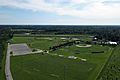
Bethalto Sports Complex


See also
 In Spanish: Bethalto (Illinois) para niños
