
Bethel, Maine facts for kids
Quick facts for kids
Bethel, Maine
|
|
|---|---|

Bethel Common
|
|
| Motto(s):
"Maine's Most Beautiful Mountain Village"
|
|

Bethel, Maine
Location in Maine

Bethel, Maine
Location in the United States
|
|
| Country | United States |
| State | Maine |
| County | Oxford |
| Incorporated | 1796 |
| Villages | Bethel East Bethel Mayville West Bethel |
| Area | |
| • Total | 65.91 sq mi (170.71 km2) |
| • Land | 64.60 sq mi (167.31 km2) |
| • Water | 1.31 sq mi (3.39 km2) |
| Elevation | 679 ft (207 m) |
| Population
(2020)
|
|
| • Total | 2,504 |
| • Density | 39/sq mi (15.0/km2) |
| Time zone | UTC-5 (Eastern (EST)) |
| • Summer (DST) | UTC-4 (EDT) |
| ZIP codes |
04217, 04286
|
| Area code(s) | 207 |
| FIPS code | 23-04825 |
| GNIS feature ID | 0582352 |


Bethel is a town in Oxford County, Maine, United States. The population was 2,504 at the 2020 census. It includes the villages of Bethel and West Bethel. The town is home to Gould Academy, a private preparatory school, and is near the Sunday River ski resort.
Contents
History

An Abenaki Indian village was once located on the north side of the Androscoggin River, but had been abandoned before its subsequent English settlement. In 1769, the township was granted as Sudbury-Canada by the Massachusetts General Court to Josiah Richardson of Sudbury, Massachusetts and others (or their heirs) for services at the Battle of Quebec in 1690. It was first settled in 1774 when Nathaniel Segar of Newton, Massachusetts started clearing the land.
The Revolutionary War, however, delayed many grantees from taking up their claims. Only 10 families resided at Sudbury-Canada when it was plundered on August 3, 1781 during the last Indian attack in Maine. Two inhabitants, Benjamin Clark and Nathaniel Segar, were abducted and held captive in Quebec until the war's conclusion, after which the community grew rapidly. On June 10, 1796, Sudbury-Canada Plantation was incorporated as Bethel, the name taken from the Book of Genesis and meaning "House of God."
In 1802, a trade road (now Route 26) was completed from Portland to Errol, New Hampshire, passing through Bethel and bringing growth. More settlers and businesses arrived. Crops were planted on fertile intervales and meadows formerly cultivated by Indians. Bethel became one of the best farming towns in the state, especially for hay and potatoes. In winter, farmers found work logging, with the lumber cut at sawmills operated by water power from streams. Other manufacturers produced flour, leather and harnesses, furniture, boots and shoes, carriages, and marble and granite work. The Bethel House, a large hotel, was built in 1833.
On March 10, 1851, the Atlantic and St. Lawrence Railroad opened to Bethel, carrying freight and summer tourists eager to escape the noise, heat and pollution of cities. Between the Civil War and World War I, Bethel was a fashionable summer resort. Several hotels were built facing the common or on Bethel Hill. Begun in 1863, The Prospect Hotel was the largest, with a cupola from which guests could observe the mountains. Tally-ho coaches provided tours through wilderness landscapes of the White Mountains and Maine. Dr. John G. Gehring's famed clinic for nervous disorders attracted many wealthy patients. Between 1897 and 1926, important figures in the music world performed at the Maine Music Festivals organized by William Rogers Chapman. But with the advent of the automobile, tourists were no longer restricted by the limits of train service, but were free to explore. Consequently, many big hotels built near the tracks lost patrons, declined and were eventually torn down. The Prospect Hotel was largely destroyed by fire in 1911. The National Training Laboratories was established at Bethel by psychologist Kurt Lewin in 1947, but its headquarters moved to Alexandria, Virginia in 2005. Nevertheless, the town remains popular with tourists for its beautiful natural setting and historic charm.
Geography
According to the United States Census Bureau, the town has a total area of 65.91 square miles (170.71 km2), of which, 64.60 square miles (167.31 km2) of it is land and 1.31 square miles (3.39 km2) is water. Located among the Oxford Hills, Bethel is drained by the Androscoggin River.
Demographics
| Historical population | |||
|---|---|---|---|
| Census | Pop. | %± | |
| 1800 | 616 | — | |
| 1810 | 975 | 58.3% | |
| 1820 | 1,267 | 29.9% | |
| 1830 | 1,620 | 27.9% | |
| 1840 | 1,994 | 23.1% | |
| 1850 | 2,253 | 13.0% | |
| 1860 | 2,523 | 12.0% | |
| 1870 | 2,286 | −9.4% | |
| 1880 | 2,077 | −9.1% | |
| 1890 | 2,209 | 6.4% | |
| 1900 | 1,835 | −16.9% | |
| 1910 | 1,930 | 5.2% | |
| 1920 | 1,792 | −7.2% | |
| 1930 | 2,025 | 13.0% | |
| 1940 | 2,034 | 0.4% | |
| 1950 | 2,367 | 16.4% | |
| 1960 | 2,408 | 1.7% | |
| 1970 | 2,220 | −7.8% | |
| 1980 | 2,340 | 5.4% | |
| 1990 | 2,329 | −0.5% | |
| 2000 | 2,411 | 3.5% | |
| 2010 | 2,607 | 8.1% | |
| 2020 | 2,504 | −4.0% | |
| U.S. Decennial Census | |||
2010 census
As of the census of 2010, there were 2,607 people, 1,121 households, and 707 families living in the town. The population density was 40.4 inhabitants per square mile (15.6/km2). There were 1,861 housing units at an average density of 28.8 per square mile (11.1/km2). The racial makeup of the town was 97.2% White, 0.5% African American, 0.2% Native American, 0.5% Asian, 0.5% from other races, and 1.0% from two or more races. Hispanic or Latino of any race were 1.2% of the population.
There were 1,121 households, of which 29.7% had children under the age of 18 living with them, 47.6% were married couples living together, 9.5% had a female householder with no husband present, 5.9% had a male householder with no wife present, and 36.9% were non-families. 29.1% of all households were made up of individuals, and 13.2% had someone living alone who was 65 years of age or older. The average household size was 2.33 and the average family size was 2.83.
The median age in the town was 42.9 years. 23.3% of residents were under the age of 18; 6.1% were between the ages of 18 and 24; 23.6% were from 25 to 44; 31.1% were from 45 to 64; and 15.9% were 65 years of age or older. The gender makeup of the town was 48.0% male and 52.0% female.
Arts and culture
Sites of interest
-
- Dr. Moses Mason House (1813)
- O'Neil Robinson House (1823)
- The Bethel Inn Resort
Education
- Maine School Administrative District 44 (MSAD 44)
- Crescent Park Elementary School
- Telstar Regional Middle/High School
- Gould Academy, a private coeducational preparatory school
Notable people
- Henry J. Bean, judge and state representative in Oregon
- Matt Bevin (born 1967), Gould Academy student, businessman and Governor of Kentucky (2015–2019)
- Richard Blanco, 2013 U.S. presidential inaugural poet
- Timothy J. Carter, ME Representative for the 25th Congress and Luther C. Carter, NY Representative for the 36th Congress, both sons of Dr. Timothy Carter, the first physician to settle in the town
- Simon Dumont, Freeskier
- Cuvier Grover, Civil War era general
- Edwin Osgood Grover, Professor of Books at Rollins College
- Frederick Grover, Professor of Botany at Oberlin College
- La Fayette Grover, fourth Governor of Oregon, member of the United States House of Representatives and member of the United States Senate
- Thomas Holt, architect
- Moses Mason, physician, congressman
- Edward Sylvester Morse (1838–1925), Gould Academy student and director of a predecessor to the Peabody Essex Museum in Salem, Massachusetts
- Mary Ann Frost Stearns Pratt, wife of Mormon leader Parley Pratt
- Patty Bartlett Sessions, midwife and plural wife of Joseph Smith
- Marshall Stedman, actor/director, playwright, author and drama teacher
- Philip Hunter Timberlake, entomologist
- James S. Wiley, congressman
Images for kids
-
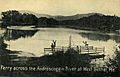
Ferry across the Androscoggin River at West Bethel in 1909
-
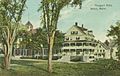
The Prospect Hotel, largest in Bethel, as it appeared in 1909
-
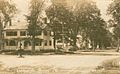
Church Street in c. 1912
-
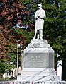
Memorial to American Civil War veterans
-
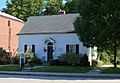
Bethel Public Library
-
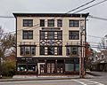
Cole Block Bethel Maine
-
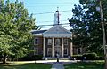
Gould Academy
-
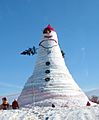
Bethel's Olympia Snow Woman (122 ft, 2008), named for Senator Olympia Snowe
-
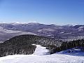
Sunday River Ski Resort near Bethel
-
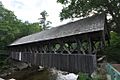
Sunday River Covered Bridge near Bethel
-
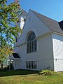
Methodist Church
-
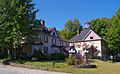
Victoria Inn


See also
 In Spanish: Bethel (Maine) para niños
