
Bethel Island facts for kids

USGS aerial imagery of Bethel Island (right) and Jersey Island (left).
|
|

Bethel Island
Location in Sacramento-San Joaquin River Delta

Bethel Island
Location in San Francisco Bay Area

Bethel Island
Location in California

Bethel Island
Location in the United States
|
|
| Geography | |
|---|---|
| Location | Northern California |
| Coordinates | 38°01′53″N 121°38′27″W / 38.03131°N 121.640787°W |
| Adjacent bodies of water | San Joaquin River |
| Area | 3,500 acres (1,400 ha) |
| Administration | |
| State | |
| County | Contra Costa |
| Demographics | |
| Population | approx. 3700 |
|
Bethel Island
|
|
|---|---|
| Country | |
| State | |
| County | Contra Costa |
| Government | |
| • Type | Special act district |
| Area | |
| • Total | 5.82 sq mi (15.07 km2) |
| • Land | 5.25 sq mi (13.60 km2) |
| • Water | 0.57 sq mi (1.47 km2) 0% |
| Elevation | -7 to -15 ft (-2 m) |
| Population
(2020)
|
|
| • Total | 2,131 |
| • Density | 405.83/sq mi (156.69/km2) |
| Time zone | UTC-8 (PST) |
| • Summer (DST) | UTC-7 (PDT) |
| ZIP code |
94511
|
| Area code(s) | 925 |
| FIPS code | 06-06210 |
| GNIS feature IDs | 1658045, 2407834 |

Bethel Island is an island in the Sacramento–San Joaquin River Delta of Contra Costa County, California, approximately 10 kilometres (6.2 mi) east of Antioch. The island describes itself as "the heart of the California Delta."
Bethel Island (formerly known as Bethell, Bethell Ranch, Bethel Tract, Sand Mound Ranch, Sand Mound Tract) is also a census-designated place (CDP) on the island. The population at the 2010 census was 2,137, a 7.6 percent decline from 2,312 at the 2000 census. The community of Bethel Island is governed as a Special Act District created by the California State legislature and named the Bethel Island Municipal Improvement District (BIMID). It is a popular destination for recreation seekers, especially hunters, fishermen and boaters.
Contents
History
Bethel Island was named for the Bethell Brothers, Frank and Warren Bethell, who formed the first successful farm on the island, called Sand Mound Ranch. Frank Bethell was appointed postmaster of the first post office; however, a pious clerk at the U.S. Postal office did not want the name "Bet Hell" and dropped the additional "L" to make it "Bethel", like the Hebrew term בית אל beth el which translates to "House of God," is known for its recreational activities. The island's reputation as such began in 1930, with Blanche and Jack Farrar founding a park with swimming, picnicking and other outdoor activities. This park would eventually be called Farrar Park. Remsburg Marina was started by Warren Remsburg in 1938, and in 1944 a fishing resort called Frank's had gained popularity on the island. The resort was built by the Andronico family. By the 1950s the area became popular with sport fishermen and the rich. Frank Bethell and Warren Bethell's widow, Ann Youree (Hamilton) Bethell sold their interest in the island in 1901. Ann went on to form a successful ranch in Almaden Valley and established the Bethell Block in downtown San Jose (site of the current Federal Building).
Geography
Bethel Island, California, is located in East Contra Costa County. It is one of the western islands within the California Delta region. The 1,450 ha (3,600-acre) island is bounded on the west and northwest by Taylor Slough, on the north and east by Piper Slough, on the southeast by Sand Mound Slough, on the east by Frank's Tract, and on the southwest by Dutch Slough. The island is approximately 3,500 acres (1,416 ha) in size.
Governance
The Bethel Island Municipal Improvement District (BIMID) has five directors, elected from the local community. They are responsible primarily for maintaining the levee around the island. They also have responsibilities for water supply and drainage; parks and playgrounds; and the local airports.
BIMID was created by the California State Legislature in 1960, replacing Reclamation District No. 1619. BIMID owns 100 acres (40 ha) of land in the center of the island between Bethel Island Road and Piper Road. Appromiately 85 acres (34 ha) is used for sourcing sand to maintain the levee; plus approximately 15 acres (6 ha) used to plant new trees to mitigate for tree removal elsewhere on the island.
The BIMID property on Stone Road consists of the District offices, a meeting room and a small equipment yard.
Amenities
The island is mostly below sea level, with a 14.9 mile perimeter levee. The area is home to approximately 3,700 people, with 1,300 residential houses on the island, plus four mobile home parks, 13 commercial marinas, a commercial business area and agricultural land.
Parks and recreation
Bethel Island Golf Course designed by Bob Baldock, is home to Bethel Island Men's Golf Club, which is affiliated to Northern California Golf Association (NCGA) and offers official USGA handicaps.
Demographics
| Historical population | |||
|---|---|---|---|
| Census | Pop. | %± | |
| 2000 | 2,312 | — | |
| 2010 | 2,137 | −7.6% | |
| 2020 | 2,131 | −0.3% | |
| U.S. Decennial Census | |||
2010
At the 2010 census Bethel Island had a population of 2,137. The population density was 384.1 people per square mile (148.3/km2). The racial makeup of Bethel Island was 1,843 (86.2%) Caucasian, 40 (1.9%) African American, 15 (0.7%) Native American, 46 (2.2%) Asian, 4 (0.2%) Pacific Islander, 119 (5.6%) from other races, and 70 (3.3%) from two or more races. Hispanic or Latino of any race were 280 people (13.1%).
The census reported that 2,123 people (99.3% of the population) lived in households, 14 (0.7%) lived in non-institutionalized group quarters, and no one was institutionalized.
There were 1,026 households, 153 (14.9%) had children under the age of 18 living in them, 409 (39.9%) were opposite-sex married couples living together, 77 (7.5%) had a female householder with no husband present, 54 (5.3%) had a male householder with no wife present. There were 86 (8.4%) unmarried opposite-sex partnerships, and 7 (0.7%) same-sex married couples or partnerships. 384 households (37.4%) were one person and 166 (16.2%) had someone living alone who was 65 or older. The average household size was 2.07. There were 540 families (52.6% of households); the average family size was 2.66.
The age distribution was 260 people (12.2%) under the age of 18, 132 people (6.2%) aged 18 to 24, 326 people (15.3%) aged 25 to 44, 845 people (39.5%) aged 45 to 64, and 574 people (26.9%) who were 65 or older. The median age was 52.8 years. For every 100 females, there were 115.0 males. For every 100 females age 18 and over, there were 118.3 males.
There were 1,327 housing units at an average density of 238.5 per square mile (92.1/km2),of which 1,026 were occupied, 805 (78.5%) by the owners and 221 (21.5%) by renters. The homeowner vacancy rate was 5.6%; the rental vacancy rate was 17.0%. 1,616 people (75.6% of the population) lived in owner-occupied housing units and 507 people (23.7%) lived in rental housing units.
2000
At the 2000 census there were 2,312 people, 1,113 households, and 605 families in the CDP. The population density was 449.5 people per square mile (173.7/km2). There were 1,345 housing units at an average density of 261.5 per square mile (101.0/km2). The racial makeup of the CDP was 90.10% White, 1.43% Black or African American, 0.99% Native American, 0.95% Asian, 0.09% Pacific Islander, 2.90% from other races, and 3.55% from two or more races. 8.78% of the population were Hispanic or Latino of any race. Of the 1,113 households 17.0% had children under the age of 18 living with them, 41.2% were married couples living together, 7.5% had a female householder with no husband present, and 45.6% were non-families. 35.8% of households were one person and 13.9% were one person aged 65 or older. The average household size was 2.08 and the average family size was 2.66.
The age distribution was 15.9% under the age of 18, 4.6% from 18 to 24, 24.1% from 25 to 44, 34.4% from 45 to 64, and 20.9% 65 or older. The median age was 48 years. For every 100 females, there were 104.6 males. For every 100 females age 18 and over, there were 109.3 males.
The median household income was $44,569 and the median family income was $53,929. Males had a median income of $47,431 versus $26,786 for females. The per capita income for the CDP was $26,739. About 5.3% of families and 8.8% of the population were below the poverty line, including 12.5% of those under age 18 and 8.7% of those age 65 or over.
Images for kids
-
Newspaper clipping from San Francisco Call January 15, 1898
-
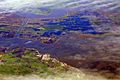
California Delta at flood stage, 2009. Bethel Island is at bottom left of image.

