
Bethlehem Township, New Jersey facts for kids
Quick facts for kids
Bethlehem Township, New Jersey
|
|
|---|---|
|
Township
|
|
| Township of Bethlehem | |
 |
|

Map of Bethlehem Township in Hunterdon County. Inset: Location of Hunterdon County in New Jersey.
|
|

Census Bureau map of Bethlehem Township, New Jersey
|
|

Bethlehem Township, New Jersey
Location in Hunterdon County, New Jersey

Bethlehem Township, New Jersey
Location in New Jersey

Bethlehem Township, New Jersey
Location in the United States
|
|
| Country | |
| State | |
| County | |
| Earliest mention | 1730 |
| Incorporated | February 21, 1798 |
| Named for | Bethlehem |
| Government | |
| • Type | Township |
| • Body | Township Committee |
| Area | |
| • Total | 20.80 sq mi (53.87 km2) |
| • Land | 20.68 sq mi (53.57 km2) |
| • Water | 0.12 sq mi (0.30 km2) 0.56% |
| Area rank | 135th of 565 in state 13th of 26 in county |
| Elevation | 814 ft (248 m) |
| Population
(2010)
|
|
| • Total | 3,979 |
| • Estimate
(2019)
|
3,854 |
| • Rank | 414th of 566 in state 12th of 26 in county |
| • Density | 192.1/sq mi (74.2/km2) |
| • Density rank | 510th of 566 in state 19th of 26 in county |
| Time zone | UTC−05:00 (Eastern (EST)) |
| • Summer (DST) | UTC−04:00 (Eastern (EDT)) |
| ZIP Code | |
| Area code(s) | 908 |
| FIPS code | 3401905650 |
| GNIS feature ID | 0882189 |
Bethlehem Township is a township in Hunterdon County, New Jersey, United States. It is part of the New York metropolitan area. As of the 2010 United States Census, the township's population was 3,979, reflecting an increase of 159 (+4.2%) from the 3,820 counted in the 2000 Census, which had in turn increased by 716 (+23.1%) from the 3,104 counted in the 1990 Census.
Contents
History
Bethlehem was first mentioned in official records dating back to 1730, though details of its formation are uncertain. Bethlehem was incorporated as one of New Jersey's initial 104 townships by an act of the New Jersey Legislature on February 21, 1798. Portions of the township were taken to form Kingwood Township (1749, date uncertain), Alexandria Township (March 5, 1765), Union Township (February 17, 1853), Junction borough (February 20, 1895, now known as Hampton borough), Bloomsbury (March 30, 1905) and Glen Gardner (March 26, 1919).
The township was named for the city of Bethlehem.
Geography
According to the United States Census Bureau, the township had a total area of 20.828 square miles (53.944 km2), including 20.711 square miles (53.642 km2) of land and 0.117 square miles (0.303 km2) of water (0.56%). The township is an exurb of New York City, lying on the western fringe of the New York metropolitan area, as part of the Newark-Union, NJ-PA Metropolitan Division, which is in turn a part of the New York City Metropolitan Area.
The Musconetcong River forms the township's northern border with Warren County. The northern half of the Township consists of the Musconetcong Valley while the southern half is covered by the Musconetcong Mountains. The southwest corner of the township lies on what is known as the Hunterdon Plateau.
The landscape is mainly rural in nature, featuring farms and forests, scattered with newer housing developments and older farm homes.
Unincorporated communities, localities and place names located partially or completely within the township include Charlestown, Jugtown, Ludlow, Polktown, Swinesburg, Valley and West Portal.
Mailing addresses
Residents and businesses in Bethlehem Township have mailing addresses to nearby towns including Clinton Hampton, Bloomsbury,NJ (and even Asbury, New Jersey which is located in neighboring Warren County), as 'Bethlehem Township' itself is not a mailing address.
-
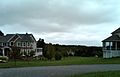
Large houses in a modern housing development in Bethlehem Township, NJ

Surrounding communities
 |
Franklin Township | Washington Township (Warren) Glen Gardner Hampton |
|
|
| Bloomsbury Greenwich Township (Warren) Pohatcong Township (Warren) |
Lebanon Township | |||
| Holland Township Alexandria Township |
Union Township |
Climate
| Climate data for Bethlehem Township, NJ | |||||||||||||
|---|---|---|---|---|---|---|---|---|---|---|---|---|---|
| Month | Jan | Feb | Mar | Apr | May | Jun | Jul | Aug | Sep | Oct | Nov | Dec | Year |
| Record high °F (°C) | 74.0 (23.3) |
77.0 (25.0) |
88.0 (31.1) |
94.0 (34.4) |
99.0 (37.2) |
102.0 (38.9) |
106.0 (41.1) |
104.0 (40.0) |
105.0 (40.6) |
97.0 (36.1) |
84.0 (28.9) |
75.0 (23.9) |
106.0 (41.1) |
| Average high °F (°C) | 36.8 (2.7) |
39.9 (4.4) |
49.8 (9.9) |
61.3 (16.3) |
72.0 (22.2) |
80.2 (26.8) |
85.1 (29.5) |
83.1 (28.4) |
75.6 (24.2) |
64.4 (18.0) |
52.8 (11.6) |
41.6 (5.3) |
61.9 (16.6) |
| Average low °F (°C) | 18.4 (−7.6) |
20.0 (−6.7) |
28.1 (−2.2) |
37.0 (2.8) |
46.9 (8.3) |
56.0 (13.3) |
61.7 (16.5) |
59.9 (15.5) |
52.0 (11.1) |
40.0 (4.4) |
32.2 (0.1) |
24.0 (−4.4) |
39.7 (4.3) |
| Record low °F (°C) | −18.0 (−27.8) |
−16.0 (−26.7) |
−6.0 (−21.1) |
14.0 (−10.0) |
25.0 (−3.9) |
34.0 (1.1) |
41.0 (5.0) |
37.0 (2.8) |
27.0 (−2.8) |
18.0 (−7.8) |
2.0 (−16.7) |
−14.0 (−25.6) |
−18.0 (−27.8) |
| Average precipitation inches (mm) | 3.78 (96) |
3.16 (80) |
4.27 (108) |
4.30 (109) |
4.62 (117) |
4.64 (118) |
5.16 (131) |
3.67 (93) |
4.31 (109) |
4.48 (114) |
3.82 (97) |
4.29 (109) |
50.5 (1,280) |
| Source: <Flemington 5 NNW Weather Station= > | |||||||||||||
Bethlehem Township falls under the 'Northern New Jersey' climate zone. According to the Office of the New Jersey State Climatologist at Rutgers University, the Northern climate zone covers about one-quarter of New Jersey and consists mainly of elevated highlands and valleys which are part of the Appalachian Uplands. Surrounded by land, this region can be characterized as having a continental climate with minimal influence from the Atlantic Ocean, except when the winds contain an easterly component. Prevailing winds are from the southwest in summer and from the northwest in winter. Being in the northernmost portion of the state, and with small mountains up to 1,800 feet in elevation, the Northern Zone normally exhibits a colder temperature regime than other climate regions of the State of New Jersey. This difference is most dramatic in winter when average temperatures in the Northern Zone can be more than ten degrees Fahrenheit cooler than in the Coastal Zone. Annual snowfall averages 40 to 50 inches in the northern zone as compared with an average of 10-15 inches in the extreme south.
Bethlehem Township falls under the USDA 6b Plant Hardiness zone.
Wildlife and ecosystem
Various animals are native to central-western New Jersey, including red fox (vulpes vulpes), black bear, groundhogs, wild turkeys, deer, squirrels, chipmunks, a variety of birds, and a plethora of insects and vegetation. There are also some fish in the streams of the county.
Trees include deciduous varieties and evergreen varieties.
Black bears are the largest land mammals in New Jersey and are known to be most abundant in the northern-western regions of the state, including Bethlehem Township.
Demographics
| Historical population | |||
|---|---|---|---|
| Census | Pop. | %± | |
| 1790 | 1,335 | — | |
| 1810 | 1,728 | — | |
| 1820 | 2,002 | 15.9% | |
| 1830 | 2,032 | 1.5% | |
| 1840 | 2,370 | 16.6% | |
| 1850 | 2,746 | 15.9% | |
| 1860 | 1,859 | −32.3% | |
| 1870 | 2,211 | 18.9% | |
| 1880 | 2,830 | 28.0% | |
| 1890 | 2,308 | −18.4% | |
| 1900 | 1,634 | −29.2% | |
| 1910 | 980 | −40.0% | |
| 1920 | 798 | −18.6% | |
| 1930 | 735 | −7.9% | |
| 1940 | 791 | 7.6% | |
| 1950 | 857 | 8.3% | |
| 1960 | 1,090 | 27.2% | |
| 1970 | 1,385 | 27.1% | |
| 1980 | 3,045 | 119.9% | |
| 1990 | 3,104 | 1.9% | |
| 2000 | 3,820 | 23.1% | |
| 2010 | 3,979 | 4.2% | |
| 2019 (est.) | 3,854 | −3.1% | |
| Population sources: 1800-1920 1840 1850-1870 1850 1870 1880-1890 1890-1910 1910-1930 1930-1990 2000 2010 * = Lost territory in previous decade |
|||
Census 2010
As of the census of 2010, there were 3,979 people, 1,344 households, and 1,148 families residing in the township. The population density was 192.1 per square mile (74.2/km2). There were 1,386 housing units at an average density of 66.9 per square mile (25.8/km2)*. The racial makeup of the township was 95.65% (3,806) White, 0.98% (39) Black or African American, 0.10% (4) Native American, 1.88% (75) Asian, 0.00% (0) Pacific Islander, 0.50% (20) from other races, and 0.88% (35) from two or more races. [[Hispanic (U.S. Census)|Hispanic or Latino of any race were 4.02% (160) of the population.
There were 1,344 households out of which 41.1% had children under the age of 18 living with them, 77.0% were married couples living together, 4.8% had a female householder with no husband present, and 14.6% were non-families. 11.9% of all households were made up of individuals, and 5.0% had someone living alone who was 65 years of age or older. The average household size was 2.96 and the average family size was 3.22.
In the township, the population was spread out with 27.6% under the age of 18, 6.2% from 18 to 24, 18.1% from 25 to 44, 38.4% from 45 to 64, and 9.7% who were 65 years of age or older. The median age was 44.2 years. For every 100 females there were 100.8 males. For every 100 females ages 18 and old there were 100.6 males.
The Census Bureau's 2006-2010 American Community Survey showed that (in 2010 inflation-adjusted dollars) median household income was $127,540 (with a margin of error of +/- $12,090) and the median family income was $130,580 (+/- $16,200). Males had a median income of $95,694 (+/- $16,468) versus $70,069 (+/- $27,112) for females. The per capita income for the borough was $44,477 (+/- $4,087). About 0.6% of families and 1.0% of the population were below the poverty line, including 1.1% of those under age 18 and none of those age 65 or over.
Census 2000
As of the 2000 United States Census there were 3,820 people, 1,266 households, and 1,092 families residing in the township. The population density was 183.3 people per square mile (70.8/km2). There were 1,303 housing units at an average density of 62.5 per square mile (24.1/km2). The racial makeup of the township was 97.51% White, 0.86% African American, 0.10% Native American, 1.02% Asian, 0.05% Pacific Islander, 0.03% from other races, and 0.42% from two or more races. Hispanic or Latino of any race were 1.62% of the population.
There were 1,266 households, out of which 43.6% had children under the age of 18 living with them, 80.3% were married couples living together, 3.9% had a female householder with no husband present, and 13.7% were non-families. 10.3% of all households were made up of individuals, and 3.3% had someone living alone who was 65 years of age or older. The average household size was 3.02 and the average family size was 3.26.
In the township the population was spread out, with 29.5% under the age of 18, 5.0% from 18 to 24, 29.6% from 25 to 44, 29.4% from 45 to 64, and 6.5% who were 65 years of age or older. The median age was 39 years. For every 100 females, there were 101.2 males. For every 100 females age 18 and over, there were 99.9 males.
The median income for a household in the township was $88,048, and the median income for a family was $92,768. Males had a median income of $69,063 versus $41,806 for females. The per capita income for the township was $35,298. None of the families and 1.0% of the population were living below the poverty line, including no under eighteens and 10.0% of those over 64.
Most common first ancestries reported in Bethlehem Township were German (25.2%), Italian (14.7%), Irish (14.4%), Polish (9.2%), English (7.6%), United States or American (6.1%), French (except Basque) (3.3%).
The most common places of birth for the foreign-born residents were India (22%), Germany (18%), United Kingdom (12%), Austria (9%), Russia (7%), Poland (5%), Netherlands (4%).
Parks and recreation
Spruce Run State Park and Reservoir, part of the New Jersey State Park system, is located near Bethlehem Township in close-by Clinton Township. It is possible to walk or bike to Spruce Run from Bethlehem Township.
Transportation
_between_Exit_11_and_Exit_7_in_Bethlehem_Township,_Hunterdon_County,_New_Jersey.jpg)
Roads and highways
As of May 2010[update], the township had a total of 57.76 miles (92.96 km) of roadways, of which 42.26 miles (68.01 km) were maintained by the municipality, 7.86 miles (12.65 km) by Hunterdon County and 7.64 miles (12.30 km) by the New Jersey Department of Transportation.
Bethlehem Township is well-connected to major metropolitan areas and cities (such as the Lehigh Valley in Pennsylvania and New York City) via Interstate 78 / U.S. 22 and Route 173. While I-78/US 22 pass through without any interchanges, the nearest exit is just outside the township in bordering Bloomsbury (Exit 7) and Union Township (Exit 11).
Anderson Road, located within Bethlehem Township, begins in neighboring Union Township and ends in Bethlehem Township as a dead-end, or cul-de-sac. Consequently, Anderson Road cannot be accessed internally through Bethlehem Township; it can only be accessed through Union Township.
Public transportation
Public transportation is limited to The LINK, a public bus service which serves Hunterdon County. Fares range from about $2.00 to $10.00. Funding for operation of the Hunterdon County LINK System is provided by Hunterdon County, NJ Transit and the Federal Transit Administration.
Rail / Lehigh Line
The Norfolk Southern Railway's Lehigh Line (formerly the mainline of the Lehigh Valley Railroad), runs through Bethlehem Township on its way to Phillipsburg, New Jersey.
Gallery
-
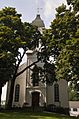
Bethlehem Presbyterian Church, built 1871 on the site of two earlier churches

- Bethlehem Township School District's 2014–15 School Report Card from the New Jersey Department of Education
Education
Students in public school for pre-kindergarten through eighth grade attend the schools of the Bethlehem Township School District. As of the 2018–19 school year, the district, comprised of two schools, had an enrollment of 358 students and 45.0 classroom teachers (on an FTE basis), for a student–teacher ratio of 8.0:1. Schools in the district (with 2018–19 enrollment data from the National Center for Education Statistics) are Thomas B. Conley Elementary School with 233 students in grades PreK-5 and Ethel Hoppock Middle School with 121 students in grades 6–8.
-

Ethel Hoppock Middle School diploma cover
-
Thomas B. Conley Elementary School
Public school students in ninth through twelfth grades attend North Hunterdon High School in Annandale, which also serves students from Clinton Town, Clinton Township, Franklin Township, Lebanon Borough and Union Township. As of the 2018–19 school year, the high school had an enrollment of 1,584 students and 123.2 classroom teachers (on an FTE basis), for a student–teacher ratio of 12.9:1. The school is part of the North Hunterdon-Voorhees Regional High School District, which also includes students from Califon, Glen Gardner, Hampton, High Bridge, Lebanon Township and Tewksbury Township, who attend Voorhees High School.
Eighth grade students from all of Hunterdon County are eligible to apply to attend the high school programs offered by the Hunterdon County Vocational School District, a county-wide vocational school district that offers career and technical education at its campuses in Raritan Township and at programs sited at local high schools, with no tuition charged to students for attendance.
Notable people
People who were born in, residents of, or otherwise closely associated with Bethlehem Township include:
- John T. Bird (1829–1911), member of the United States House of Representatives from 1869 to 1873.
- Johnston Cornish (1858–1920), represented New Jersey's 4th congressional district in the United States House of Representatives from 1893 to 1895.
- Anne Marie Letko (born 1969), two-time Olympian, in 1996 and 2000.
- Daniel Morgan (1736–1802), Revolutionary War general and a United States Representative from the State of Virginia.
- James Parker (1776–1868), member of the House of Representatives from New Jersey.
- Bennet Van Syckel (1830-1921), Associate Justice of the New Jersey Supreme Court from 1869 to 1904.
See also
 In Spanish: Municipio de Bethlehem (Nueva Jersey) para niños
