
Bethungra, New South Wales facts for kids
This page is about the locality near Junee, New South Wales. For for the former convent and now residence in Canterbury, Sydney, see Bethungra, Canterbury. For other uses, see Bethungra.
Quick facts for kids BethungraNew South Wales |
|
|---|---|

Entering Bethungra
|
|

Bethungra
Location in New South Wales
|
|
| Population | 164 (2016 census) |
| Postcode(s) | 2590 |
| Elevation | 310 m (1,017 ft) |
| Location |
|
| LGA(s) | Junee Shire |
| County | Clarendon |
| State electorate(s) | Cootamundra |
| Federal Division(s) | Riverina |
Bethungra is a locality in Junee Shire in the South West Slopes region of New South Wales, Australia situated on the Olympic Highway about 13 kilometres northeast of Illabo and 24 kilometres southwest of Cootamundra.
History
Bethungra Post Office opened on 1 December 1875.
Just to the north of the town lies the Bethungra Spiral, a rail spiral built on the Main South railway line to ease the gradients when the line was duplicated between 1941 and 1946. A railway station was located in the town between 1878 and the 1980s, and has now been demolished.
Heritage listings
Bethungra has a number of heritage-listed sites, including:
- Main Southern railway: Bethungra Spiral
Gallery
-
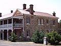
Bethungra Hotel aka Hotel Shirley
-
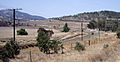
Bethungra Spiral
-
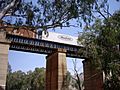
Overpass just south of Bethungra Spiral


All content from Kiddle encyclopedia articles (including the article images and facts) can be freely used under Attribution-ShareAlike license, unless stated otherwise. Cite this article:
Bethungra, New South Wales Facts for Kids. Kiddle Encyclopedia.